
You must be logged in to view this content. Click Here to become a member of IndyWX.com for full access. Already a member of IndyWx.com All-Access? Log-in here.
Category: Tropics
Permanent link to this article: https://indywx.com/video-much-cooler-wet-and-blustery-weekend-on-deck/
Sep 04
VIDEO: Gordon’s Remnant Moisture Arrives To Close The Week…
You must be logged in to view this content. Click Here to become a member of IndyWX.com for full access. Already a member of IndyWx.com All-Access? Log-in here.
Permanent link to this article: https://indywx.com/video-gordons-remnant-moisture-arrives-to-close-the-week/
Sep 04
Gordon’s Remnants Deliver A Wet Weekend…
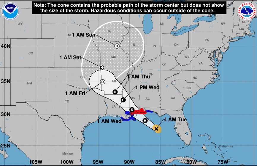
This morning, Tropical Storm Gordon continues to churn in the central Gulf of Mexico. Gordon should make landfall late tonight or very early Wednesday morning along the AL/ MS Gulf Coast as a strong Tropical Storm or minimal Hurricane.
 Mostly dry, hot, and humid weather will continue to gain headlines, locally, through midweek. Thereafter, a combination of ingredients spell for unsettled times late week and a rather wet weekend.
- Remnant moisture of Gordon will “curl” around the periphery of an upper level ridge to our east
- A “wavy” frontal boundary will drop south into the Ohio Valley this weekend, entraining the remnant tropical moisture

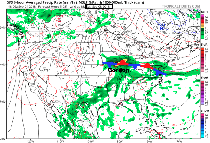
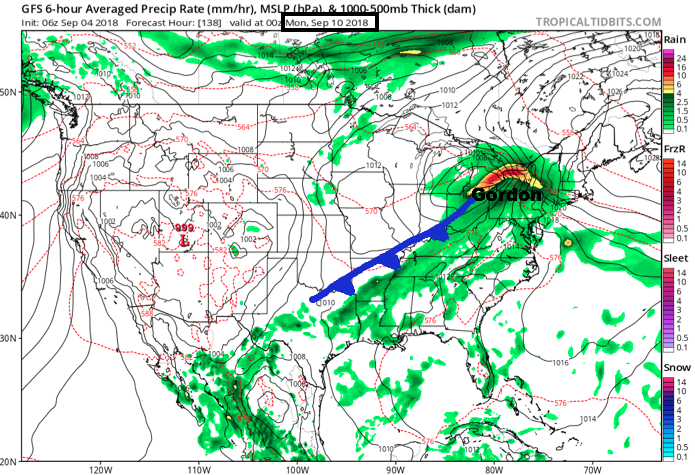 Eventually, Gordon’s remnants will track into the Northeast Sunday night into Monday and will allow the stationary front to sweep through the Ohio Valley. This will provide a drier air mass as we open the new work week.
Beforehand, precipitable water values will exceed 2″ at times this weekend, in association with Gordon’s remnants, and this will promote periods of heavy rain. As things stand now, most widespread heavy rain is expected to arrive Saturday, but it’s a safe bet to plan for wet weather Friday through Sunday.
 Widespread 1″ to 2″ rainfall totals are expected this weekend across central Indiana, including locally heavier amounts.
Permanent link to this article: https://indywx.com/gordons-remnants-deliver-a-wet-weekend/
Sep 03
VIDEO: Gordon Takes Aim On The N-Central Gulf Coast; Unsettled Close To The Week…
You must be logged in to view this content. Click Here to become a member of IndyWX.com for full access. Already a member of IndyWx.com All-Access? Log-in here.
Permanent link to this article: https://indywx.com/video-gordon-takes-aim-on-the-n-central-gulf-coast-unsettled-close-to-the-week/
Sep 02
Tropics Begin To Heat Up…
To no surprise as the traditional peak of the hurricane season approaches (September 10th), the tropics are beginning to turn more active. In addition to Florence, new disturbed weather, currently in the Caribbean, may spin up on it’s journey northwest into the Gulf of Mexico early this week.

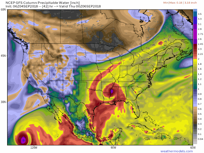
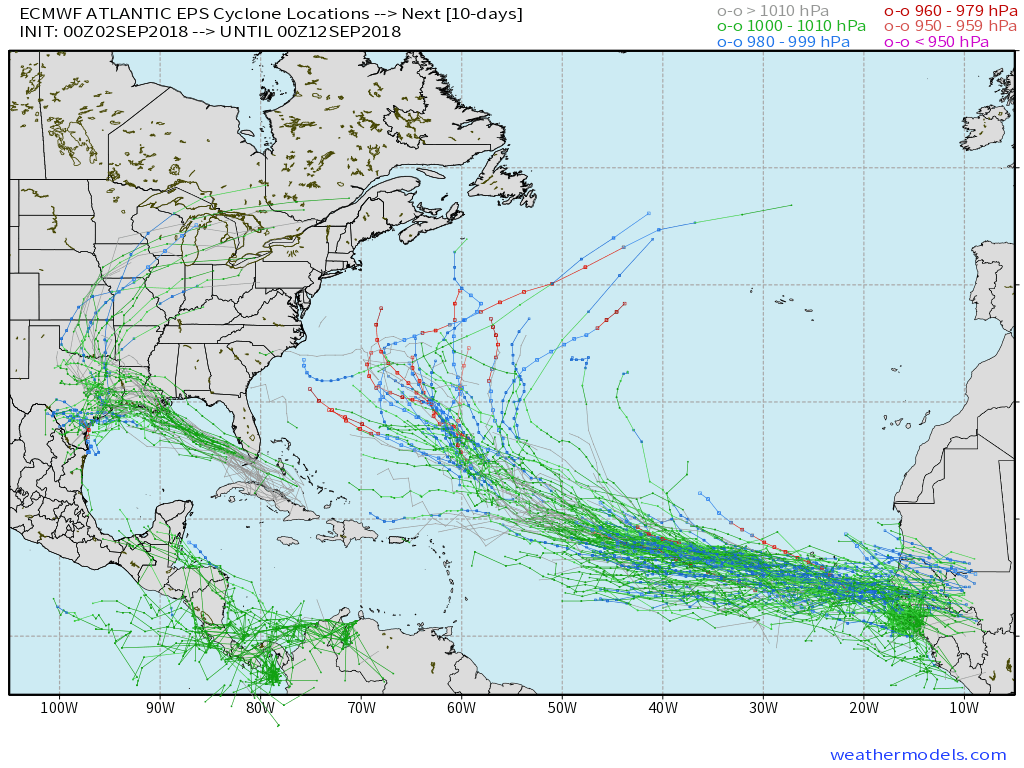 The tropical disturbance entering the GOM (Gulf of Mexico) early week will begin to find a more favorable upper level environment for further strengthening. While we always have to be cautious with any sort of tropical entity in the Gulf of Mexico this time of year, the greatest immediate concern is for locally heavy rain along the northern Gulf Coast early and middle parts of the week.
Then attention will shift to the potential of remnant tropical moisture “curling” around the periphery of the eastern ridge during the latter half of the week. While far too early to get specific, chances are there for elevated hefty rain chances for areas from the MS Valley into the Mid West as we get set to close the shortened work week and head into next weekend.
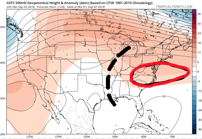
 While the axis of heaviest rainfall will have to be fine tuned, confidence is high on unsettled times returning around these parts beginning Wednesday- thanks to the combination of an approaching cold front and remnant tropical moisture.
Permanent link to this article: https://indywx.com/tropics-begin-to-heat-up/