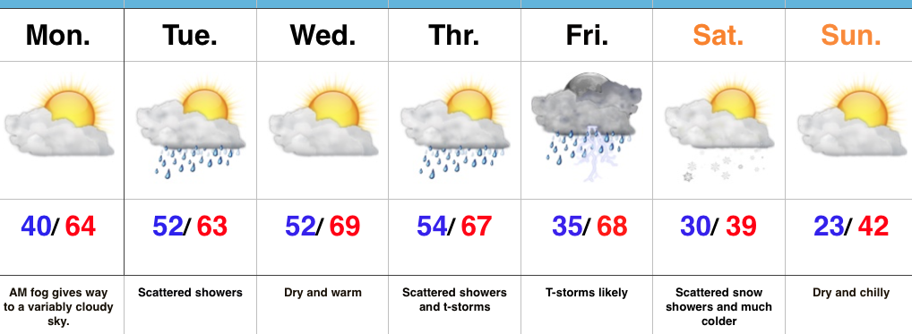
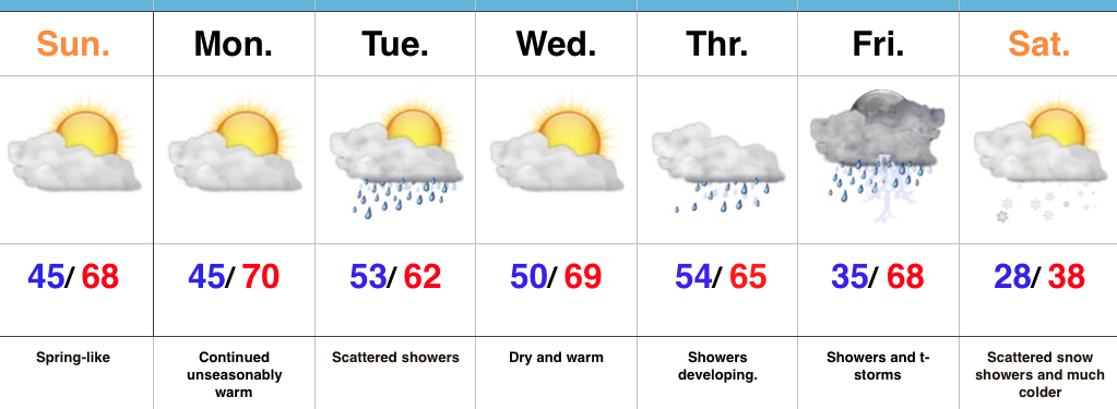
Spring-Like Now, But Winter Returns This Weekend…
 Highlights:
- Dense morning fog
- Tuesday showers
- Severe potential Friday
- Much colder this weekend
Two Seasons This Week…We’re starting the work week with dense fog across central Indiana. This will eventually burn off to a variably cloudy sky by afternoon, along with continued unseasonably warm temperatures.
A weak weather system will press through the state Tuesday and this will help lead to a period of showers Tuesday morning into the early afternoon hours. This won’t be a big event (most neighborhoods should accumulate between 0.10″-0.25″ of rain), but plan to pack the rain gear as you leave the house Tuesday morning.
A much stronger storm system will impact the region Thursday into Friday. As strong low pressure passes by to our northwest it’ll help pull anomalously warm, moist air northward Friday. Strong to severe thunderstorms may occur along the strong cold front that will pass late Friday. While we still have time to “fine tune” details on timing, early thinking would place greatest emphasis on large hail and damaging wind potential. Stay tuned.
Much colder air will hit with authority Friday night and set-up a wintry weekend. The spring-like feel of this past weekend will be all but a distant memory and flurries may fly Saturday morning in the colder, blustery air.
Upcoming 7-Day Precipitation Forecast:
- Snowfall: Trace
- Rainfall: 0.50″ – 1.00″
 Despite the lack of sunshine this morning, temperatures continue to run much milder than average. We’re currently running nearly 20° above where we should be at the 9a hour.
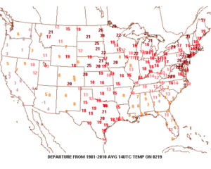 A quiet start to the work week is ahead as high pressure dominates early on. That said, a weak storm system will scoot through the state Monday night and Tuesday morning and this will help offer up the chance of showers and perhaps a rumble of thunder.
 The next (more significant) storm system will pose a severe weather risk to close the week. We continue to keep a close eye on Friday and the Storm Prediction Center is as well, with western IL, IN, and western KY in their Day 6 Outlook. It’s still early, but the primary focus with the severe potential this storm may pose will be large hail and damaging straight line winds. Stay tuned as we continue to analyze the latest data.
 We’ll turn sharply colder Friday night and Saturday. Though it’ll feel much colder, we’ll really only “chill” to seasonal levels, including a gusty northwesterly breeze Saturday.
 Longer-term, we’re rumbling into a much more active weather pattern through the mid range period. As the mean trough sets-up position in the west, the ridge will flex it’s muscle across the east yet again during early portions of Week 2. This will set the stage for a repeat of what we deal with Friday and, accordingly, we’ll have to monitor early next week for portions of severe weather yet again.
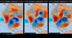
 Highlights:
 The Gulf of Mexico is boiling warm (running 1°-3° C above normal) and this will aid in transporting moisture-rich air north. As storms eject out of the Rockies and Plains, one would tend to believe anomalously warm dew points and precipitable water values will be available.
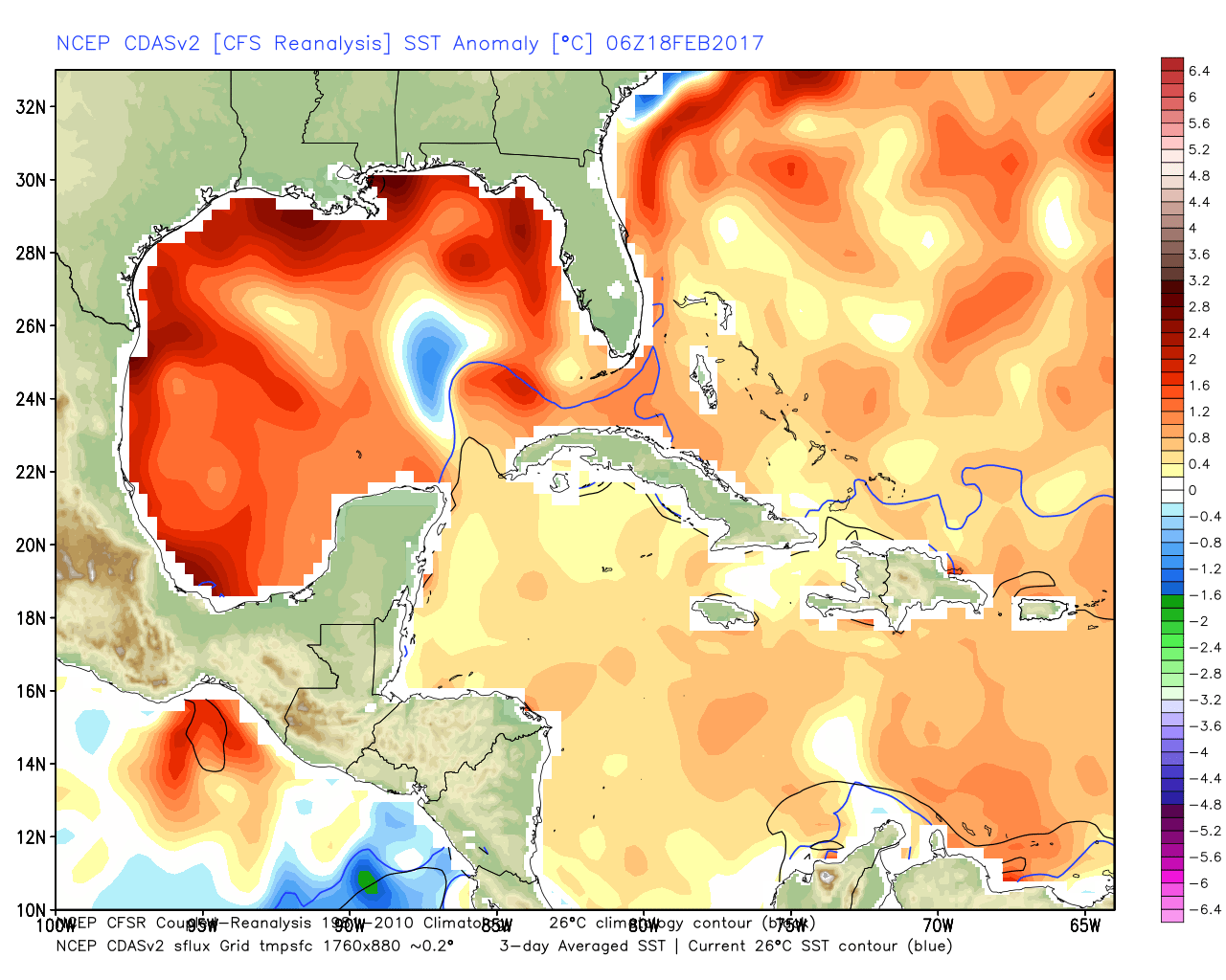 The JMA Weeklies show an active stretch developing as we progress through the next few weeks.
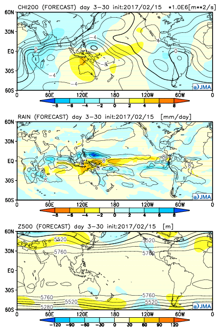 As we rumble deeper into the spring months, the mean trough position should be located across the west. The end result should be a mean storm track that runs into the Ohio Valley- courtesy of resistance from an eastern ridge (that warm water in the Gulf and East Coast screams the mean ridge position should be located across the east coast). Confidence is greater than normal on a busy severe weather season.