VIDEO: Brief “Speed-Bump” On The Way To A Spring-Like Weekend…
You must be logged in to view this content. Click Here to become a member of IndyWX.com for full access. Already a member of IndyWx.com All-Access? Log-in here.
You must be logged in to view this content. Click Here to become a member of IndyWX.com for full access. Already a member of IndyWx.com All-Access? Log-in here.
 Highlights:
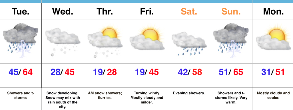
Dramamine Required…The “tug of war” weather pattern will continue through the forecast period with winter and spring each having difficulty taking control for any length of time…
Walking out the door this morning will have you checking the calendar to see if it, indeed, is early February. As we type this Tuesday morning, temperatures are in the lower 60s across many central IN neighborhoods. That unseasonably warm air mass will help fuel t-storm development through the mid afternoon hours and a couple of these storms could reach severe levels, including damaging winds.
The cold front will sweep through the state this afternoon putting an end to the storminess and resulting in colder air spilling into the region tonight. A disturbance will quickly move into the colder air mass Wednesday and this will result in an area of snow developing during the day. This is a tricky system as the recent warm, wet ground would argue against much, if any, accumulation. However, localized banding features likely will lead to more intense snowfall rates across portions of north-central IN Wednesday afternoon-evening and this would overcome the warm surface temperatures and lead to local slushy accumulations. We feel at this time, the best bet for a potential 1″-2″ slushy snowfall will be just north of the city and we’ll have a snowfall forecast map out this evening (want to give the 12z modeling a good look).
We’ll turn much colder Thursday before wrapping up the work week with a windy, milder feel Friday.
The next storm will arrive over the weekend and serve to give the thermometer another spring-like look, but, similar to today, storms will follow Sunday…
Upcoming 7-Day Precipitation Forecast:
That sunshine sure was nice…while it lasted. Clouds lowered and thickened through the afternoon and a wind-driven mist is falling across most of central Indiana this evening. That mist will…
You must be logged in to view this content. Click Here to become a member of IndyWX.com for full access. Already a member of IndyWx.com All-Access? Log-in here.
You must be logged in to view this content. Click Here to become a member of IndyWX.com for full access. Already a member of IndyWx.com All-Access? Log-in here.
 Highlights:
Beautiful Super Bowl Sunday; Changes Await…We suggest taking your pregame Super Bowl parties outside today to enjoy what’ll be a rare sunny day! Temperatures will also be milder today, topping out in the upper 40s.
Unfortunately, the sunny skies won’t last as clouds increase Monday morning and showers move in by afternoon. As surface low pressure tracks into the Great Lakes, heavier rains and embedded thunderstorms will increase Monday night into Tuesday morning. A couple of these storms could become strong to severe, and include strong and damaging winds and hail. Colder air will pour into Indiana on gusty northwest winds Tuesday night behind the frontal passage.
Our attention will then shift to a colder regime for mid week. We have to iron out the details, but forecast models suggest an area of low pressure will scoot across the central Plains to the East Coast Wednesday into Thursday. This will spread moisture north into the colder air mass and the result may be a swath of accumulating snow north of the low’s track, including central Indiana. We’ll be left with very cold air to wrap up the work week.
Next weekend, the “tug of war” regime will continue. Southwest winds will usher in milder conditions Saturday with showers.
Upcoming 7-Day Precipitation Forecast: