VIDEO: Nice SB Sunday & Tuesday Severe Potential…
You must be logged in to view this content. Click Here to become a member of IndyWX.com for full access. Already a member of IndyWx.com All-Access? Log-in here.
You must be logged in to view this content. Click Here to become a member of IndyWX.com for full access. Already a member of IndyWx.com All-Access? Log-in here.
1.) A cold close to the work week can be expected with highs today only topping out in the upper 20s (average highs are in the upper 30s).
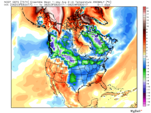 2.) What at one time looked to be a significant weekend storm now may not even deliver any precipitation at all to the region. A flurry is possible, but most should remain precipitation-free this weekend. Expect a gusty southwest wind developing SB Sunday. Highs around freezing Saturday will zoom into the middle 40s Sunday. Lows Saturday morning in the middle 10s will rise into the upper 20s to around 30 Sunday morning.
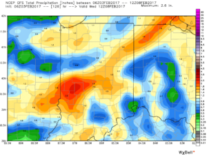
 3.) A more significant storm system will cut for the Great Lakes early next week and this will deliver gusty showers and embedded thunderstorms. A couple of stronger storms aren’t out of the question. Locally heavy rains can be expected, including amounts of 1″-1.5″ (locally heavier totals).

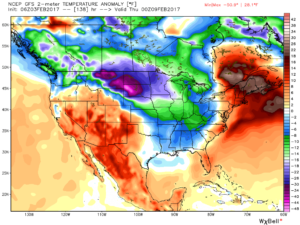
 4.) Cold air will rush back into the region behind the storm and snow showers and squalls are likely by Wednesday.

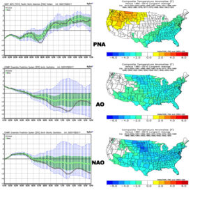
 5.) Longer-term, a real fight is developing on the overall direction we’re heading as February evolves. Analog methods and teleconnections (shown below) would yield bullish cold signals and give hope to winter enthusiasts. However, modeling isn’t in agreement on the wintry ideas. In fact, some modeling is very spring-like as mid-Feb nears. Stay tuned as we try and iron out the details this weekend. Updates will come.
 Highlights:
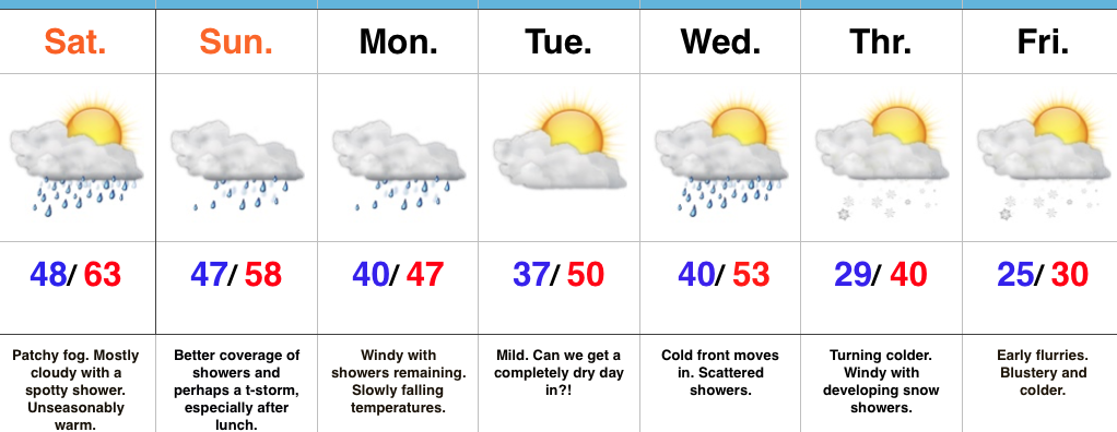
Rare January White Leg Alert…The big news this weekend will be temperatures close to 30 degrees above normal and a legitimate spring feel. Average highs across central IN this time of year are in the middle 30s and temperatures this afternoon will zoom to the lower-middle 60s. Patchy morning fog and drizzle will be with us, but we’re remaining optimistic we could squeeze a couple of looks at the sun during the day. Count yourself lucky if you do, indeed, see that weird giant bright thing in the sky! 😉
A developing storm system will track east across the central Plains and into the TN Valley this weekend. This will result in a significant severe weather outbreak across the south and increasing rain chances here for the back half of the weekend. The magnitude of the rain and potential embedded storms remains in question, but shower chances will at least be on the increase Sunday afternoon into the evening. We note short-term, higher resolution modeling hitting the locally heavy rain threat harder than global data early this morning (centered on Sunday evening) and we’ll keep a close eye on things as most central IN communities remain waterlogged. Winds will increase Monday- NE shifting to the N and gusts to 40 MPH with leftover showers continuing.
Tuesday will present a bit of a break in our active pattern before a fast-moving cold front blows into town Wednesday with scattered showers amidst blustery conditions.
We turn colder (you knew this incredibly mild pattern had to break at some point) late week and upper level energy will help ignite snow showers with the return of the wintry feel Thursday into Friday.
Upcoming 7-Day Precipitation Forecast:
You must be logged in to view this content. Click Here to become a member of IndyWX.com for full access. Already a member of IndyWx.com All-Access? Log-in here.
 Highlights:
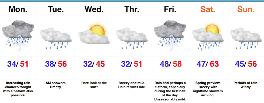
Have The Rain Gear Handy…While we’ll enjoy unseasonably mild temperatures, the wet and unsettled theme we’ve been dealing with as of late we’ll continue this week.
Most of the daytime today will feature more dry time than wet with just scattered showers expected before more widespread rain and embedded thunderstorms arrive by nightfall. Wet and periodically stormy times continue tonight into the early morning hours Tuesday. After a predawn high in the mid 50s, temperatures will slowly fall during the day Tuesday before remaining steady in the middle to upper 40s for the balance of the afternoon.
We may get a brief (rare) look at the sun Wednesday as we’ll be in between weather systems, but have no fear, as our next storm will be developing to our south and arrive with showers Thursday. 🙂 Rain and perhaps a thunderstorm continue Friday, especially through the first half of the day.
The majority of Saturday will feature dry and warm (early spring-like) conditions, but clouds will increase during the second half of the day and showers will push north into the state at night. Windy, wet conditions continue Sunday.
Longer-term, forecast models continue to paint a significantly colder, wintry pattern as we go through the last week of the month.
Upcoming 7-Day Precipitation Forecast: