Category: Summer

Very Humid; Splash And Dash Storms…

Mon.

Tue.

Wed.

Thr.

Fri.

Sat.

Sun.

 Status-weather-showers-day-icon

 Status-weather-clouds-icon

 Status-weather-clouds-icon

 Status-weather-showers-day-icon

 Status-weather-showers-day-icon

 Status-weather-showers-day-icon

 Status-weather-showers-day-icon

68/ 85

70/ 89

71/ 90

70/ 89

71/ 85

68/ 86

67/ 84 

Light

– – –

– – –

Light

Light

Light

Light

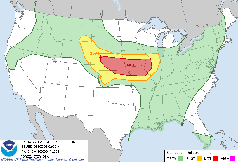
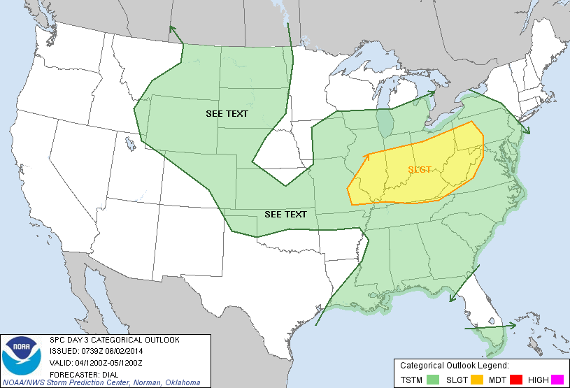
We’ve been timing this whole weather thing just right, haven’t we?! It seems as if late spring and meteorological summer has already featured countless pleasant weekends and whatever rain and storms we deal with arrive during the work week.  I say let’s just keep going with that schedule, what about you?!  🙂  As promised, a much more humid and warmer brand of air will greet us to kick off the new work week and isolated to widely scattered showers and thunderstorms will dot themselves across the central Indiana landscape.  With all of the humidity in place, it’s going to be tough to get a completely rain-free day region wide this week, but we’re targeting Tuesday and Wednesday as days with limited, to no, storm coverage.  Additionally, we’ve reached the time of year where it’s mighty tough to get into any sort of all day rain (unless some type of tropical feature is in play) so expect many dry hours on the days we’re featuring rain chances and some places won’t see any rain, whatsoever.  This is what we call the “splash and dash” variety of showers and storms.  All in all, the upcoming week will feature weather conditions very similar to summer!

Permanent link to this article: https://indywx.com/very-humid-splash-and-dash-storms/

Perfect Bonfire Weather…

Fri.

Sat.

Sun.

Mon.

Tue.

Wed.

Thr.

 Status-weather-showers-day-icon

 Status-weather-clear-icon

 Status-weather-clouds-icon

 Status-weather-storm-night-icon

 Status-weather-showers-day-icon

 Status-weather-clouds-icon

 Status-weather-showers-day-icon

58/ 71

49/ 73

53/ 82

67/ 82

69/ 87

70/ 87

69/ 83 

Light

– – –

– – –

Moderate

Light

– – –

Light

A noisy thunderstorm rolled through the northern suburbs last night.  I was awaken from a deep sleep around 12:30 to plenty of lightning, thunder, and heavy rain.  While there are a couple showers around this morning, those will track east rather quickly and a pleasant northwest wind will usher in amazingly cool and refreshing air for this time of year.  Simply put (yet again) today and Saturday will feature weather that just cannot get any better this time of year.  We forecast many outlying communities away from the city to reach the upper 40s Saturday morning and highs both today and Saturday will only climb into the lower 70s.  Ahhh, anyone else craving fall?!  For those summer lovers, have no fear as heat and humidity will build late in the weekend and really set the tone for the week ahead.  Additionally, a couple round of showers and heavy thunderstorms will be possible next week.  Right now we target Monday and Thursday for best chances of heavy rain.

Permanent link to this article: https://indywx.com/perfect-bonfire-weather/

Monday Morning Video Update; Severe Weather Potential And Heavy Rain…

An active few days lie ahead though it won’t rain and storm the entire time, and many dry hours can be expected over the course of the next few days.  The video covers the details below!

Tuesday is shaping up to be a very active severe weather day to our west.

Tuesday is shaping up to be a very active severe weather day to our west.

Wednesday will feature severe weather chances across the Ohio Valley.

Wednesday will feature severe weather chances across the Ohio Valley.


Permanent link to this article: https://indywx.com/monday-morning-video-update-severe-weather-potential-and-heavy-rain/

Saturday Morning Weather Chit-Chat!

A beautiful weekend is underway.  Stepping out on the deck this morning for my morning coffee was much more refreshing when compared to the past few days.  Dew points in the 40s along with temperatures around 60 made for a very nice feel this morning.

This morning’s visible satellite shows clear skies continue.  Definitely plan to get outside today, but with that sun screen!

20140531_1145_EVV_vis

Most of Sunday will be nice, as well, but clouds and humidity levels will increase Sunday afternoon and evening and a couple of showers and thunderstorms will be possible as early as Sunday night.

Future radar shows scattered thunderstorms around the region Sunday night.

hires_ref_indy_43

Warmth and humidity will return to oppressive levels for the better part of next week and this will help add fuel to the fire for heavy rain and potentially strong thunderstorms.  Model data handles the timing differently with next week’s storm system (as is usual at this stage), but agrees on the heavy rain potential.  Widespread 1.5″ to 2″ rainfall appears to be a good bet at this point next week.

Upcoming 10 day rainfall potential, per the Canadian forecast model, shows the wet pattern unfolding, including excessive rains for some locales.

cmc_total_precip_ma_41

The GFS (below) pushes the front south a bit quicker and in return delivers drier air next weekend.  The European forecast model doesn’t agree.

gfs_ptype_slp_east_20

Also of interest, the GFS continues to spin up Gulf of Mexico “mischief” late next week…

gfs_ptype_slp_east_33


Permanent link to this article: https://indywx.com/saturday-morning-weather-chit-chat/

Much Less Humid Weekend…

Fri. Sat. Sun. Mon. Tue. Wed. Thr.               63/ 80 57/ 80 58/ 83 69/ 82 70/ 84 62/ 80 70/ 85  – –…

You must be logged in to view this content. Click Here to become a member of IndyWX.com for full access.  Already a member of IndyWx.com All-Access?  Log-in here.

Permanent link to this article: https://indywx.com/much-less-humid-weekend/