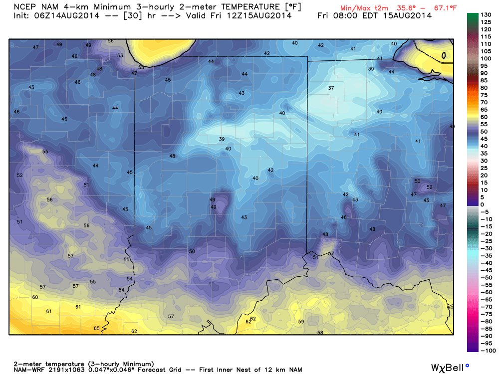
Category: Summer
|
Mon.
|
Tue.
|
Wed.
|
Thr.
|
Fri.
|
Sat.
|
Sun.
|
|

|

|

|

|

|

|

|
|
62/ 83
|
55/ 69
|
51/ 71
|
49/ 74
|
55/ 75
|
56/ 79
|
59/ 82
|
|
Light
|
Light
|
Light
|
– – –
|
– – –
|
– – –
|
– – –
|
A cold front will blow through the region this evening. We still think a line of showers and thunderstorms will develop along this front and race through the region late afternoon into the early evening hours. Winds will then shift to the northwest and help usher in what we’re calling “autumn in July” for the better part of the week. Walking out the door Tuesday morning certainly won’t feel like mid July as northwest winds blow and temperatures are in the middle 50s. Highs Tuesday likely won’t make it out of the 60s. Tuesday and Wednesday’s rain chances will come primarily from instability-driven afternoon showers as the region remains under the influence of an unseasonably deep upper low. More sunshine and drier conditions are ahead mid to late week, along with continued cooler than normal temperatures.
Permanent link to this article: https://indywx.com/autumn-in-july-on-our-doorstep/
-
Filed under 7-Day Outlook, Forecast, Forecast Discussion, Heavy Rain, Independence Day, Rain, Severe Weather, Summer, T-storms, Unseasonably Cool Weather
-
July 4, 2014
|
Fri.
|
Sat.
|
Sun.
|
Mon.
|
Tue.
|
Wed.
|
Thr.
|
|

|

|

|

|

|

|

|
|
51/ 76
|
55/ 80
|
59/ 83
|
68/ 87
|
68/ 82
|
58/ 78
|
57/ 82
|
|
– – –
|
– – –
|
– – –
|
Light
|
Moderate
|
Light
|
– – –
|
Happy Independence Day! Canadian high pressure remains firmly in control of our weather today and for the majority of the weekend for that matter. As a result, look for plentiful amounts of sunshine and temperatures that will continue the cooler than normal regime we enjoyed Thursday. Today’s conditions, once again, will have that feeling of early fall. ENJOY! A more active weather pattern will return early next week as we potentially have to deal with a couple thunderstorm complexes in the Monday-Tuesday time period. Heavy rain and the chance of severe weather will return to your forecast Monday night into Tuesday and we’ll have more details around this as we move closer. A cooler and drier regime will build in by the middle portion of next week.
Permanent link to this article: https://indywx.com/sun-filled-and-unseasonably-cool/
Sun. Mon. Tue. Wed. Thr. Independence Day Sat. 70/ 83 72/ 88 72/ 85 63/ 78 59/ 74 51/ 77 54/ 82 Light…
You must be logged in to view this content. Click Here to become a member of IndyWX.com for full access. Already a member of IndyWx.com All-Access? Log-in here.
Permanent link to this article: https://indywx.com/storm-chances-remain-before-we-turn-much-cooler/
Thr. Fri. Sat. Sun. Mon. Tue. Wed. 65/ 83 64/ 85 67/ 86 71/ 87 73/ 90 73/ 89 64/ 79 – –…
You must be logged in to view this content. Click Here to become a member of IndyWX.com for full access. Already a member of IndyWx.com All-Access? Log-in here.
Permanent link to this article: https://indywx.com/nice-day-shaping-up/
Mon. Tue. Wed. Thr. Fri. Sat. Sun. 68/ 88 69/ 81 66/ 82 61/ 84 65/ 83 68/ 84 70/ 87 Light Light…
You must be logged in to view this content. Click Here to become a member of IndyWX.com for full access. Already a member of IndyWx.com All-Access? Log-in here.
Permanent link to this article: https://indywx.com/splash-and-dash-storms-to-open-the-work-week/