Category: snow

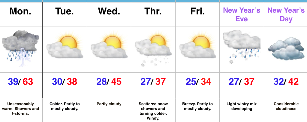
Shift Back To A Cold Pattern Awaits; What About Winter Storm Potential?

December-to-date is running colder than normal (to the tune of 2.2 degrees at IND), but the past (7) days has seen a flip in the frigid 1st half of the month.

December temperature anomalies, courtesy of Weatherbell.com.

December temperature anomalies, courtesy of Weatherbell.com.

Temperature anomalies the last 7 days. Courtesy of Weatherbell.com.

Temperature anomalies the last 7 days. Courtesy of Weatherbell.com.

The “relaxation” is temporary.  Modeling continues to advertise the recent “thaw” will give way to increasingly bitter times as we get deeper into the New Year.  By New Year’s Day we note the positive heights continuing to establish themselves across Alaska and Greenland (cold and stormy signal).  We also note the southeast ridge present, though to a lesser degree than over the past week.

jan1
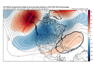
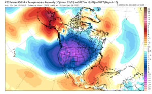
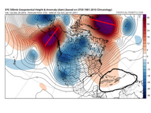
By Day (10), the cold pattern is well established over the Lower 48.  This is a coast-to-coast cold signal (heart of the cold centered over the west and central) depicted by the European ensemble, along with other modeling.

day10

ecmwf-ens_t850amean_namer_6
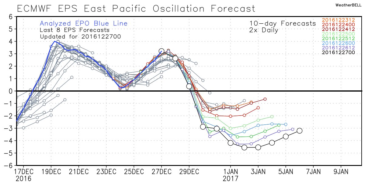
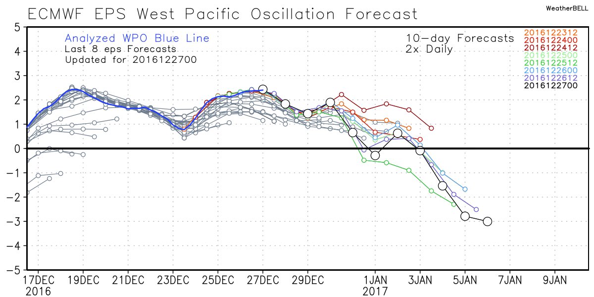
Teleconnections support a cold pattern returning.

epowpo122916

aonao122916

pna
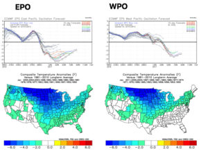
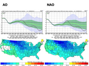
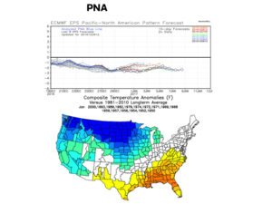
The agreement amongst teleconnections is nice to see and ups confidence in the overall direction of where this pattern is heading in regards to colder than average times looming.  The negative PNA correlates nicely with the SE ridge that continues to make itself heard from time to time over the next few weeks.  It should also be noted that the phases of the Arctic Oscillation (AO) and North Atlantic Oscillation (NAO) become more of a factor for mid and late winter.

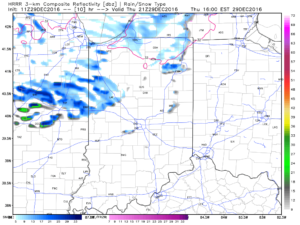
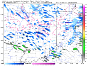
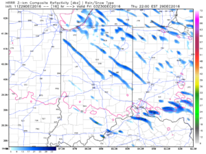
As far as storminess goes, we’ll have to handle those as they come.  The overall pattern screams towards the idea of an active Ohio Valley to interior Northeast storm track as we move forward (continuing deeper into mid and late winter, as well).  That doesn’t mean one or two storms won’t bypass our local region to the south, due to strong, cold high pressure north, but the mean storm track should put areas through the Ohio Valley in the “sweet spot” from a snow perspective throughout the majority of January, and the rest of winter, for that matter.  Depending on the position and strength of the Greenland Block will have a lot to say about things.  Needless to say, storms cutting NW into the central Lakes should be few and far between after the New Year.  Speaking of storms, we have to continue to keep an eye on the second half of next week.  At the time of this discussion, the threat is still beyond the 7-day period, but circle late next week and weekend for the potential of wintry “mischief.”

Permanent link to this article: https://indywx.com/shift-back-to-a-cold-pattern-awaits-what-about-winter-storm-potential/

Intense Snow Squalls By Evening…

One cold front moved through central Indiana last night with rain showers and a notable wind shift.  A secondary cold front will sweep through the region later this afternoon.  Not only will this deliver reinforcing cold air to wrap up the short work week, but with enough upper level energy and instability, it’ll also serve to ignite some intense snow squalls by evening.  This won’t be a “uniform” snow event, but where the squalls develop, expect rapid reduction in visibility (brief white-out conditions), and a quick coating to 1″ of snow.  Winds will also gust to 40 MPH by evening and overnight.

Here’s an idea of what the radar may look like later this evening:

4p forecast radar

4p forecast radar

6p forecast radar

6p forecast radar

10p forecast radar

10p forecast radar

If you have travel plans this evening into tonight, please allow extra time to reach your destination as these intense snow squalls lead to brief white-outs and quickly create slick travel.  Scattered snow showers will continue into Friday morning, especially across the northern and eastern sections of the state.  Friday will be a cold day as highs top out around 30.

More with an updated 7-day forecast later today!

Permanent link to this article: https://indywx.com/intense-snow-squalls-by-evening/

Snow Squalls Thursday Evening; Active Pattern…

screen-shot-2016-12-28-at-10-18-11-amHighlights:

  • Showers this evening
  • Snow squalls develop Thursday evening
  • Active weather pattern into next week

Early Sun Gives Way To Showers By Evening…A sunny, frosty start to the day will give way to an increasingly cloudy sky by afternoon and scattered showers by evening.  Latest data suggests showers arrive into central Indiana by 6-7p.  This won’t be a significant rain maker, but just enough to create damp conditions as we put a wrap on Wednesday.

A reinforcing push of cold air will blow through Thursday evening.  With enough instability and upper air energy, scattered heavy snow squalls will become likely across the region by afternoon into the evening.  This won’t be a “uniform” snow event, but some localized accumulation (thinking a coating to less than 1″ in spots), along with dramatic drops in visibility can be expected by evening as these scattered snow squalls increase in coverage.  Additionally, winds will gust to 40 MPH and will aid in creating hazardous travel at times tomorrow PM.  Scattered snow showers will continue into the day Friday.

Moving forward, we continue to eye the potential of a light wintry mix arriving on New Year’s Eve.  As of now, this doesn’t appear to be a big deal, but we’ll monitor things as new data streams in.  “Light” is the key word for now and temperatures look marginal, at best, for wintry issues.

As we rumble into next week, model consistency and overall agreement is rather non-existent.  This leads to a lower than normal confidence on the important details in regards to the early week storm system (and looking forward, towards a second storm coming along just beyond the current forecast period).  For now we’ll go with showers Monday afternoon paving way to more widespread rain Tuesday.  As colder air rushes in Tuesday night, precipitation will change to snow along with a strengthening northwest wind and an increasingly bitter feel by the middle of next week.

Upcoming 7-Day Precipitation Forecast:

  • Snowfall: 1″ – 2″
  • Rainfall: 0.50″ – 1.00″

Permanent link to this article: https://indywx.com/snow-squalls-thursday-evening-active-pattern/

New Year, New Pattern Awaits…

As we rumble through the remainder of 2016, a “transient” weather pattern awaits.  Cooler, more seasonable, air is working itself into the Ohio Valley today and will be followed by another (stronger) cold front Thursday.  That front will pack more of a punch in the cold department, along with providing opportunity for snow showers, as well.  That said, we’re still about a week off from more of a sustained cold pattern.

With the arrival of the new year, a new weather pattern will emerge as well…

The EPO (East Pacific Oscillation) and WPO (West Pacific Oscillation) will flip back to negative phases as the New Year arrives.  This will help drive the shift, initially, to a colder regime, locally.

epo

epoanom

wpo

wpoanom
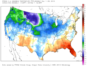
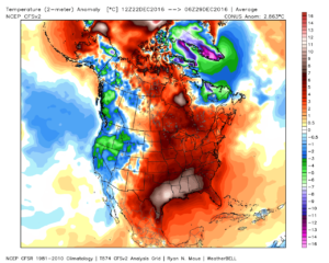
Accordingly, we see the ensemble data flipping to a colder pattern over the upcoming (10) days.  Note the low anomalies in the higher latitude regions today (Image 1) versus Day 10 (Image 2).

day1

day10
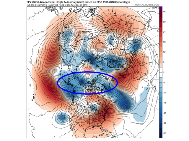
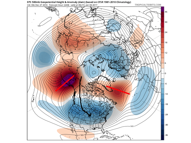
The pattern developing by Day (10) is one capable of producing another frigid regime- only January style.  Cross-polar flow sets up shop and, unlike, December, some blocking is noted, as well.  This can help the mean storm track shift further south.  (Bye-bye Great Lakes cutters, though Mid Western and Ohio Valley Snow Lovers will find a new worry in the form of suppression potential ;-)).  Individual storms will have their respected challenges, as always.  As a whole, it’s a very cold, stormy look and a pattern capable of leading to an expanding snow pack across the Lower 48.

Notes:  The new European Weeklies are in and reflect the general idea here of a more sustained cold, wintry pattern unfolding as January arrives.  The Weeklies are very cold through Weeks 2-3, in particular.  As far as snow goes, they also suggest an active storm track with numerous storms leading to an increasingly snowy regime through the middle parts of January, as well.  That said, we’re a bit hesitant to focus too much on the long-term snowfall details as the Weeklies have been too generous in the snow department over the past several weeks.  As a whole, it’s very tough to argue the pattern isn’t one that should yield the snowy “goods” in the coming weeks though.

More later!

Permanent link to this article: https://indywx.com/new-year-new-pattern-awaits/

Unseasonably Warm; Wet Day After Christmas…

screen-shot-2016-12-26-at-8-33-12-amHighlights:

  • Unseasonably warm today
  • Showers and perhaps a t-storm by lunchtime
  • Turning more seasonable later this week

Wet At Times Today…A cold front will push across the state later this afternoon.  Ahead of the front, a warm southwesterly air flow will lead to a spring-like feel on this day after Christmas.  Coverage of showers will increase by late morning and around lunchtime, including the possibility of an embedded thunderstorm.  Once the front sweeps through the region, our winds will flip to the northwest and result in a cooler feel as early as tonight.  Tuesday will feature much more seasonable conditions.

Reinforcing chilly air will blow into town Thursday afternoon and with enough upper level energy around, we’ll mention scattered snow showers in our forecast.  Colder weather will be with us to close the week and head into New Year’s weekend.

Speaking of New Year’s, we still eye a storm system around New Year’s Eve.  Confidence is low in the overall set-up in regards to storm track and timing and fine tuning will be required.  For now, we’ll simply go with a developing light wintry mix Saturday and “sure up” the details later this week.

Upcoming 7-Day Precipitation Forecast:

  • Snowfall: Dusting
  • Rainfall: 0.50″ – 0.75″

Permanent link to this article: https://indywx.com/unseasonably-warm-wet-day-after-christmas/