Category: snow

Don’t Get Lulled To Sleep…

Overall, as mild as this winter has been (particularly on the snow front), it’s easy to think we’re done with wintry precipitation- especially after this stretch of 60°+ weather.  That said, we still have to get through March, and as long-time Midwesterners know, the third month of the year can yield some wild swings, including late season wintry events.  Yes, including even the mild winters of the past…

Modeling is beginning to show at least a shift towards unseasonably cold conditions as we progress through the first couple of weeks of March.  In the face of the prolonged stretch of April-like warmth of late, this will be a shock in and of itself.


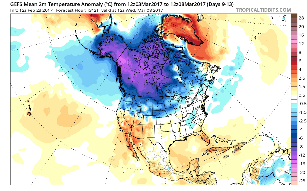
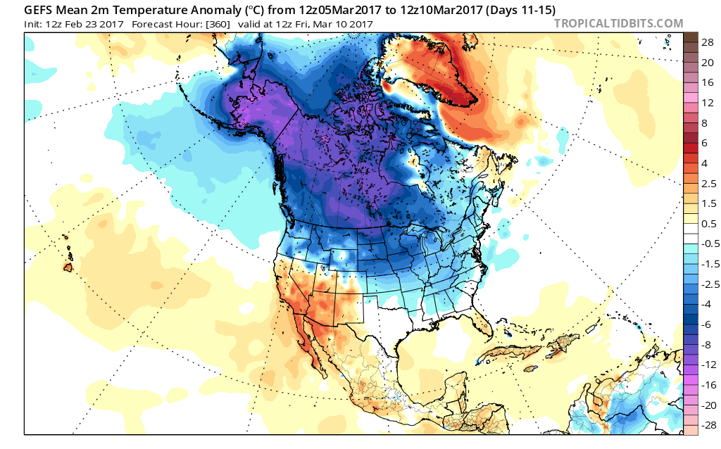
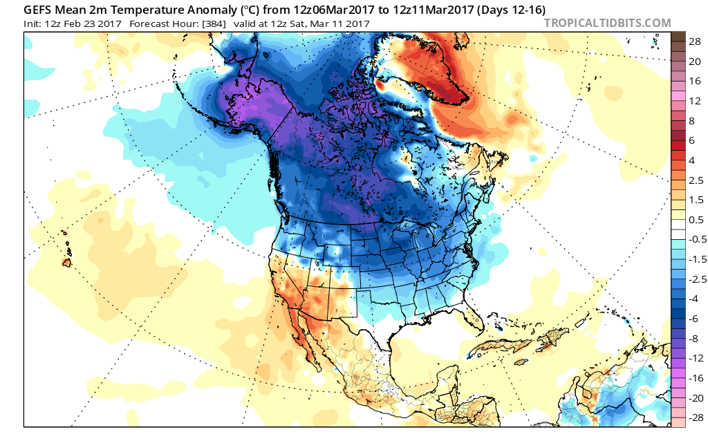
Longer-term indications would suggest the period of chilly, wintry-like, air has a window to take over, but the window is small.  Trends would seem to yield warmer solutions once past mid-month, with perhaps a “stick and hold” spring regime taking over.

Before that, we have a couple of weeks in front of us to open March that won’t only provide out-of-season cold, but we must also pay close attention to the potential of northwest flow clipper systems.  There’s no reason to get detailed and specific from this distance, but the pattern suggests we need to be on the look-out for the potential of one or two snow makers as we move through the first couple weeks of the month.  March clippers can be a headache as the March warmth south of the track of the system can help add energy and turn a weak event into an impactful snow event to the north of the low’s track.  Hoosiers don’t have to be reminded how significant March clippers can be at times.  Is this the year we have to deal with one or two of these stronger clippers?  Wouldn’t it be ironic after such a mild winter thus far?  Don’t let Mother Nature “lull” you to sleep…

Permanent link to this article: https://indywx.com/dont-get-lulled-to-sleep/

Active Pattern Ramping Up; Monitoring Multiple Storm Chances…

Highlights:

  • Spring-like air continues
  • Severe t-storm potential Friday PM
  • Much colder weekend
  • Another round of strong-severe storms next week?

Buckle Up For A Wild Ride…Morning fog (some very dense, especially north of the city) will burn off and give way to increasing sunshine today, along with unseasonably warm temperatures.  In fact, we’ll be near-record territory (Indy’s record high today is 70° and we forecast to tie that record this afternoon).  We’ll remain near record territory over the next couple of days, but our attention will, unfortunately, have to shift from the record warmth to strong-severe thunderstorm potential.

Most of Thursday will be dry, but a few scattered showers will likely dot the central IN landscape by the evening hours.  Similar to Thursday, most of the day Friday will also be dry.  It’s not until we head into Friday evening and night that we’re concerned for thunderstorms tracking through the state.  A few of these storms will likely reach severe levels.  Large hail and damaging winds are of greatest concern with the severe thunderstorms that develop.  The cold front will sweep the state Friday night and a midnight high Saturday morning in the upper 40s will crash (most of the daytime will feature temperatures in the 30s with wind chills in the 20s) and wind-whipped snow flurries can be expected.

A weak weather system is still expected late Sunday and could feature a light rain and snow mix (not a big deal).  What will be a bigger deal is a much stronger storm system rolling through the Mid West early next week.  Unfortunately, another round of strong to severe thunderstorms will be possible Tuesday…

Upcoming 7-Day Precipitation Forecast:

  • Snowfall: Trace
  • Rainfall: 1.00″ – 1.50″

Permanent link to this article: https://indywx.com/active-pattern-ramping-up-monitoring-multiple-storm-chances/

Incredible February Warmth Continues Until This Weekend…

Highlights:

  • Unseasonably warm conditions continue
  • Strong-severe t-storm potential Friday PM
  • Much colder this weekend

Spring-Like Weather Continues…A weak weather system will create the chance of showers into this afternoon, but many more dry hours can be expected than wet.  In fact, some neighborhoods won’t even see a drop of rain today.  The bigger news?  A continuation of unseasonably warm, April-like, temperatures.  In fact, we’ll turn even warmer for the second half of the work week and get back to dry time Wednesday and most of Thursday.

A strong cold front will sweep through the state Friday night.  Ahead of this front, shower and thunderstorm coverage will increase Friday afternoon into the evening hours.  Some of these storms may become strong to severe and include damaging straight line winds and hail.

We’ll then turn much colder Friday night and that will set the stage for a more seasonable weekend.  Snow flurries may fly in the blustery northwest flow Saturday.  A fast-moving weather maker will then spread a mixture of rain and wet snow across the state Sunday evening into early Monday.  Confidence is low on timing of this late weekend system and fine tuning will be required moving forward.

Upcoming 7-Day Precipitation Forecast:

  • Snowfall: Trace – Dusting
  • Rainfall: 0.25″ – 0.75″

Permanent link to this article: https://indywx.com/incredible-february-warmth-continues-until-this-weekend/

VIDEO: Spring-Like Weekend…

You must be logged in to view this content. Click Here to become a member of IndyWX.com for full access.  Already a member of IndyWx.com All-Access?  Log-in here.

Permanent link to this article: https://indywx.com/video-spring-like-weekend/

VIDEO: Brief “Speed-Bump” On The Way To A Spring-Like Weekend…

You must be logged in to view this content. Click Here to become a member of IndyWX.com for full access.  Already a member of IndyWx.com All-Access?  Log-in here.

Permanent link to this article: https://indywx.com/video-brief-speed-bump-on-the-way-to-a-spring-like-weekend/