Category: snow

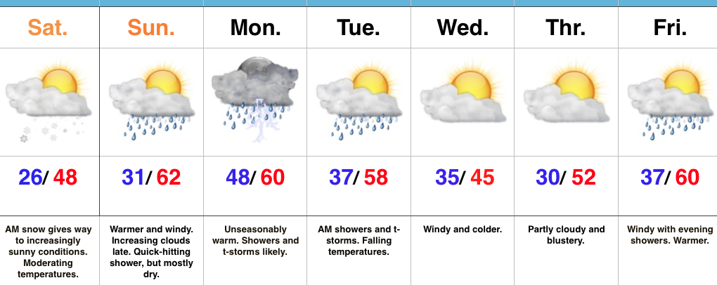
AM Snow Gives Way To Increasing Sunshine…

Highlights:

  • AM snow ends
  • Windy warm-up coming
  • Early week storms

Snowy For Some This Morning…A narrow band of heavy snow has deposited 1″-2″ for neighborhoods northeast of the city.  Places like Anderson, New Castle, and Richmond were the “sweet spot” for this event.  Thank you for the reports!

As quickly as the snow hit, it’ll depart and be a distant memory this afternoon, as increasingly sunny conditions develop, along with moderating temperatures.  This is the beginning of a weekend warm-up that will send temperatures into the lower 60s Sunday afternoon though we will have to deal with a possible passing shower and strong and gusty southwest winds.

A cold front will sweep through the state to open the work week and help increase overall coverage of showers and thunderstorms Monday- especially during the evening and nighttime hours.  Early showers Tuesday will end and give way to drier, cooler conditions for mid week.

Our next storm system will approach next weekend.  The work week will end with another windy warm-up, along with showers by evening.

Upcoming 7-Day Precipitation Forecast:

  • Snowfall:  Dusting – 1″
  • Rainfall:  0.50″ – 1.00″

Permanent link to this article: https://indywx.com/am-snow-gives-way-to-increasing-sunshine/

Lots Of Sunshine To Close The Work Week; Moderating This Weekend…

Highlights:

  • Sunny, cold close to the work week
  • AM light snow Saturday
  • Moderating with storm chances early next week

Coats And Sunglasses Required Today…We’re closing out the work week with plentiful sunshine, but temperatures will run several degrees below average.  Heavier coats will be required out the door this morning with wind chills in the teens.

A warm front will lift north through the state Saturday morning and should push an area of snow northeast with it.  The potential is present for a coating to less than 1″ of snow as this occurs early Saturday morning, especially for area northeast of the city, itself.  Despite the quick hit of morning snow, sunshine should return later in the day and our winds will shift to the southwest.  This will help temperatures recover late in the day and the moderating trend continues Sunday with PM showers.

A cold front will sweep through the region Monday into Tuesday morning with widespread showers and thunderstorms.  After a warm start to the day, temperatures will fall through the daytime hours Tuesday.  Dry, windy conditions will be with us as we push through the middle of next week.

Upcoming 7-Day Precipitation Forecast:

  • Snowfall: Dusting – 1″
  • Rainfall: 0.50″ – 1.00″

Permanent link to this article: https://indywx.com/lots-of-sunshine-to-close-the-work-week-moderating-this-weekend/

Turning Colder To Close The Work Week…

Highlights:

  • Showers with falling temperatures today
  • Rain and snow showers Thursday
  • Cold close to the work week
  • Windy weekend warm-up comes with showers

Downward Trend…Showers will increase in coverage this afternoon and evening as temperatures fall into the 40s (this afternoon) and 30s (this evening).  Certainly plan to carry the jacket with you to work and school as you’ll need it on the way home this evening.

Our next weather maker will be a fast-moving clipper system that will arrive Thursday afternoon.  Gusty showers will blow through central Indiana through the afternoon and evening hours before transitioning to snow showers and embedded heavier squalls (capable of a quick coating where the heavier squalls occur).  A dry, but cold close to the work week is ahead with highs Friday only in the middle 30s.

Just as quickly as the cold air hits, it’ll leave this weekend as a windy warm-up develops.  A flurry or sprinkle is possible Saturday as the warm front lifts north and then showers will increase in coverage, along with a strengthening southwest wind (gusts of 40 MPH +) Sunday.

A strong cold front looks to blow through the region Tuesday with showers and thunderstorms a good bet Monday night into Tuesday.

Upcoming 7-Day Precipitation Forecast:

  • Snowfall: Dusting
  • Rainfall:1.00″-1.50″

Permanent link to this article: https://indywx.com/turning-colder-to-close-the-work-week/

Transitional Week Of Weather…

Highlights:

  • Warming back up
  • Storms around Tuesday-Wednesday
  • Colder late week
  • Windy warm-up next weekend

Don’t Blink…The second half of the weekend has gotten off to a frosty, but bright start!  Unfortunately, clouds will begin to increase this afternoon.  Thankfully, the increasing clouds won’t keep temperatures from getting a significant boost this afternoon compared to the frigid air of Saturday.

A few showers will scoot through the state Monday, but most of these will be confined to the southern third of Indiana and most neighborhoods should remain rain-free.  A more significant storm system will lift northeast Tuesday and this will provide better coverage of showers and thunderstorms Tuesday (especially late in the day) into Wednesday.  After a midnight high, temperatures will fall through the daytime hours Wednesday.

Another fast-moving, weak, weather maker will impact us Thursday evening into Friday morning.  Scattered showers Thursday PM will transition to light snow showers overnight into early Friday morning.  Friday will be chilly, but moderating conditions return as early as Saturday, along with a strong and gusty southwest flow by the afternoon!

Upcoming 7-Day Precipitation Forecast:

  • Snowfall: Trace – Dusting
  • Rainfall: 1.00″ – 1.25″

Permanent link to this article: https://indywx.com/transitional-week-of-weather/

Severe T-storms This Evening Give Way To Much Colder Air This Weekend…

Highlights:

  • Record warmth
  • Severe t-storm potential this evening
  • Scattered snow showers Saturday
  • Active pattern next week

Focused On Severe Weather This Evening…Though the day is beginning on a quiet note, we’re concerned it might not end that way, as strong to severe thunderstorms impact central Indiana this afternoon and evening.  The sunshine this morning is actually something that adds further concern for the potential of explosive thunderstorm development later today.  More specifically, we’re bracketing the hours of 4p and 10p for the likelihood of storms impacting central parts of the state (west to east), and some of these may become severe.  All modes of severe weather are in play today, including large hail, damaging winds, and a tornado or two.  Please have a means of getting the latest warning information and ensure you know your family’s severe plan.  Otherwise, we forecast to shatter the record high today as we zoom all the way into the middle 70s with a gusty southerly wind.

Winter will return with authority tonight and set-up a much colder weekend.  That high in the upper 40s Saturday will actually come at midnight with falling temperatures (most of the daytime hours will feature low-mid 30s with ‘chills in the 20s), windy conditions, and scattered snow showers.

A weak weather system is looking less and less impressive for the second half of the weekend, but we’ll continue to keep a chance of light rain in our forecast by evening.

Better rain chances will begin to ramp up Monday evening and become widespread Tuesday, including the possibility of thunderstorms, as well.  The second half of next week will trend colder…

Upcoming 7-Day Precipitation Forecast:

  • Snowfall: Trace
  • Rainfall: 0.50″ – 1.00″

Permanent link to this article: https://indywx.com/severe-t-storms-this-evening-give-way-to-much-colder-air-this-weekend/