
You must be logged in to view this content. Click Here to become a member of IndyWX.com for full access. Already a member of IndyWx.com All-Access? Log-in here.
Category: Severe Weather
Permanent link to this article: https://indywx.com/2017/02/17/video-spring-like-weekend/
Feb 07
Buckle Up: Spring, Winter, Spring…
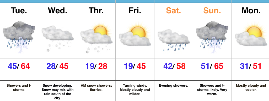 Highlights:
- Periods of storms Tuesday
- Snowy Wednesday for some
- Warming back up this weekend with storms
Dramamine Required…The “tug of war” weather pattern will continue through the forecast period with winter and spring each having difficulty taking control for any length of time…
Walking out the door this morning will have you checking the calendar to see if it, indeed, is early February. As we type this Tuesday morning, temperatures are in the lower 60s across many central IN neighborhoods. That unseasonably warm air mass will help fuel t-storm development through the mid afternoon hours and a couple of these storms could reach severe levels, including damaging winds.
The cold front will sweep through the state this afternoon putting an end to the storminess and resulting in colder air spilling into the region tonight. A disturbance will quickly move into the colder air mass Wednesday and this will result in an area of snow developing during the day. This is a tricky system as the recent warm, wet ground would argue against much, if any, accumulation. However, localized banding features likely will lead to more intense snowfall rates across portions of north-central IN Wednesday afternoon-evening and this would overcome the warm surface temperatures and lead to local slushy accumulations. We feel at this time, the best bet for a potential 1″-2″ slushy snowfall will be just north of the city and we’ll have a snowfall forecast map out this evening (want to give the 12z modeling a good look).
We’ll turn much colder Thursday before wrapping up the work week with a windy, milder feel Friday.
The next storm will arrive over the weekend and serve to give the thermometer another spring-like look, but, similar to today, storms will follow Sunday…
Upcoming 7-Day Precipitation Forecast:
- Snowfall: 1″ – 2″
- Rainfall: 0.75″ – 1.25″
Permanent link to this article: https://indywx.com/2017/02/07/buckle-up-spring-winter-spring/
Feb 06
Touching Base Monday Evening…
That sunshine sure was nice…while it lasted. Clouds lowered and thickened through the afternoon and a wind-driven mist is falling across most of central Indiana this evening. That mist will…
You must be logged in to view this content. Click Here to become a member of IndyWX.com for full access. Already a member of IndyWx.com All-Access? Log-in here.
Permanent link to this article: https://indywx.com/2017/02/06/touching-base-monday-evening/
Feb 06
VIDEO: Storms Develop Tonight; Accumulating Snow Wednesday?
You must be logged in to view this content. Click Here to become a member of IndyWX.com for full access. Already a member of IndyWx.com All-Access? Log-in here.
Permanent link to this article: https://indywx.com/2017/02/06/video-storms-develop-tonight-accumulating-snow-wednesday/
Feb 04
VIDEO: Nice SB Sunday & Tuesday Severe Potential…
You must be logged in to view this content. Click Here to become a member of IndyWX.com for full access. Already a member of IndyWx.com All-Access? Log-in here.
Permanent link to this article: https://indywx.com/2017/02/04/video-nice-sb-sunday-tuesday-severe-potential/
Jan 20
Weekend Video Update…
You must be logged in to view this content. Click Here to become a member of IndyWX.com for full access. Already a member of IndyWx.com All-Access? Log-in here.
Permanent link to this article: https://indywx.com/2017/01/20/weekend-video-update/
Nov 18
VIDEO: Stormy By Evening; Much Colder This Weekend…
You must be logged in to view this content. Click Here to become a member of IndyWX.com for full access. Already a member of IndyWx.com All-Access? Log-in here.
Permanent link to this article: https://indywx.com/2016/11/18/video-stormy-by-evening-much-colder-this-weekend/
Oct 19
VIDEO: Quick Wednesday Evening Video Update…
You must be logged in to view this content. Click Here to become a member of IndyWX.com for full access. Already a member of IndyWx.com All-Access? Log-in here.
Permanent link to this article: https://indywx.com/2016/10/19/video-quick-wednesday-evening-video-update/
Aug 24
Wednesday Evening Thoughts: For The Love Of Weather, We Have To Get Better…
Indiana is blessed with a truly incredible weather community. Please understand that I’m not just throwing around the word “community” lightly here. The relationships that have stemmed from one single…
You must be logged in to view this content. Click Here to become a member of IndyWX.com for full access. Already a member of IndyWx.com All-Access? Log-in here.
Permanent link to this article: https://indywx.com/2016/08/24/wednesday-evening-thoughts-for-the-love-of-weather-we-have-to-get-better/
Aug 16
Another Wet Day…
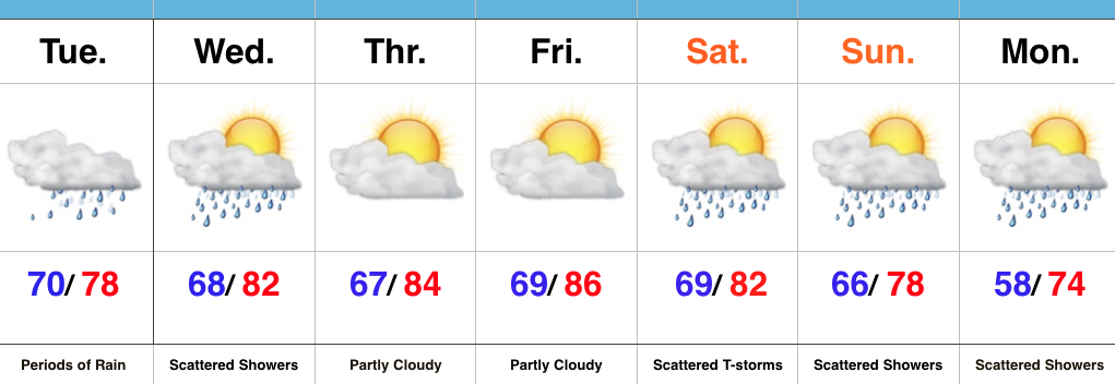 Highlights:
- Periods of rain
- Increasing sunshine as we push into late week
- Weekend cold front
Keep The Rain Gear Handy…Whew, after an incredibly busy evening, things will be much quieter today. Despite not having a severe threat, we will have to deal with wet times as periods of rain continue. Rain coverage will diminish Wednesday, but we’ll keep scattered showers in the forecast.
Drier air will arrive Thursday and Friday, including a partly cloudy sky. The next weather item on the horizon is a weekend cold front. This frontal boundary will help increase storm chances Saturday into early Sunday (a few storms Saturday evening could be on the strong side). MUCH cooler, early fall-like, air awaits next week…
Upcoming 7-Day Precipitation Forecast:
- Snowfall: 0.00″
- Rainfall: 0.75″-1.25″
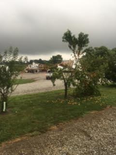
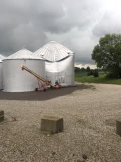
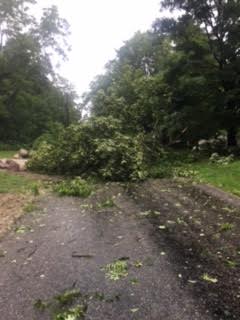
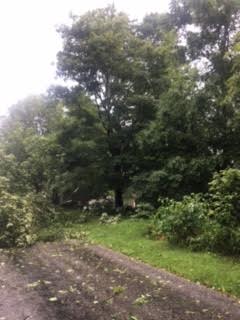
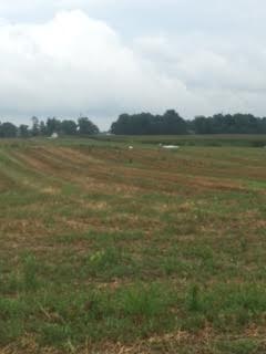
Here are a few photos I shot Monday evening (8.15.16), between 6:47p-6:55p, just after the tornado touched down in Whitestown.
Permanent link to this article: https://indywx.com/2016/08/16/another-wet-day/