Category: Rain

Feeling Like Summer!

Sun.

Mon.

Tue.

Wed.

Thr.

Fri.

Sat.

 Status-weather-showers-day-icon

 Status-weather-showers-day-icon

 Status-weather-storm-night-icon

 Status-weather-showers-day-icon

 Status-weather-showers-day-icon

 Status-weather-storm-night-icon

 Status-weather-showers-day-icon

63/ 85

66/ 87

69/ 80

65/ 83

63/ 83

69/ 80

66/ 83 

Light

Light

Moderate

Light

Light

Moderate

Light

Though we officially just welcomed in summer, we’ve been in meteorological summer since June 1st.  The meteorological seasons include June through August for summer, September through November for fall, December through February for winter, and March through May for spring.  This week we’ll feel very much like summer, including seasonable temperatures and plenty of rain and storm chances!  Coverage of those showers and thunderstorms will be widely scattered today and Monday, primarily during the afternoon and evening hours.  While everyone won’t get wet, some locally heavy downpours are possible.  Looking ahead, we target better chances of more widespread showers and thunderstorms Tuesday and again Friday. The week ahead stands to be another wet one on the precipitation front, including widespread 1.5″-2″ totals during the course of the upcoming 7 days on average.

Permanent link to this article: https://indywx.com/feeling-like-summer-2/

Line Of Storms Rumbles In Tonight…

A line of strong to severe thunderstorms has formed to our west and this line will push into central Indiana between 8-9 o’clock.  Guidance suggests this line will weaken as…

You must be logged in to view this content. Click Here to become a member of IndyWX.com for full access.  Already a member of IndyWx.com All-Access?  Log-in here.

Permanent link to this article: https://indywx.com/line-of-storms-rumbles-in-tonight/

Severe Threat Later Tonight, But Some Questions Linger…

The Storm Prediction Center has issued a Slight Risk of severe weather that includes central Indiana, primarily for potential thunderstorms late today and tonight.

day1otlk_1200

Primary Threats:

  • Large hail
  • Damaging straight line winds

Discussion:

There are a few questions regarding the potential of severe weather across our immediate region.  It’s unclear how leftover outflow boundaries from thunderstorms during the overnight will interact as they push east.  That said, it’s possible these boundaries could help ignite a couple of clusters of thunderstorms across Iowa and Illinois later this afternoon.  This activity would then ride southeast.  Should we get storms to fire, they would likely hold together as they approach western and central Indiana.  CAPE will reach 2000-2200 J/kg this evening and low level moisture will be on the uptick, as well.  We’ll have an updated post this afternoon after we have a chance to see if convection (thunderstorms) fires to our west.

Enjoy your Saturday morning!

Permanent link to this article: https://indywx.com/severe-threat-later-tonight-but-questions-abound/

Diminished, But Not Eliminated…

Fri. Sat. Sun. Mon. Tue. Wed. Thr.               70/ 85 67/ 85 65/ 85 67/ 88 69/ 83 66/ 83 63/ 82  Light Light…

You must be logged in to view this content. Click Here to become a member of IndyWX.com for full access.  Already a member of IndyWx.com All-Access?  Log-in here.

Permanent link to this article: https://indywx.com/diminished-but-not-eliminated/

Boone County, Central Indiana Flooding 6/19/14

A rather rare flood event took place across localized areas of central Indiana between Wednesday, June 18th, 2014 and Thursday, June 19th, 2014.  (27) hour rainfall totals 4pm Wednesday, June 18th through 7pm Thursday, June 19th reached 5.5″ (5) miles northwest of Zionsville, IN in southeastern Boone County, IN.  2.9″ of that rain fell in less than a (3) hour period between 4pm and 7pm Thursday, June 19th.

Local Agriculture impact:

Numerous central and southern Boone County crops experienced some sort of damage from rapid run off of the torrential rainfall.  Communities and farmland impacted included Lebanon, Whitestown, and Zionsville.

photo 5-2photo 4-3photo 3-3photo 2.PNGphoto 1-3


Ground-truth reports taken at our IndyWx.com headquarters (5 miles northwest of Zionsville, just outside Whitestown, IN) recorded 5.5″ of rain within the (27) hour period mentioned above.

Radar estimated data also shows the widespread 4-5″+ rainfall totals across Boone County over the past 24 hours- Wednesday, June 18th through Thursday, June 19th.

photo-10

Forecast model data from as early as Thursday morning suggested that particular afternoon and evening could feature training of heavy rain producing thunderstorms through central Indiana, including some embedded strong to severe thunderstorms, despite the Storm Prediction Center including central Indiana in any sort of severe weather categorical outlook (Slight Risk, or above).  That said, it should also be noted that this wasn’t a major severe weather outbreak across central Indiana, though isolated severe weather reports did come in, including a brief tornado touchdown near Anderson Thursday afternoon, along with a couple of additional severe thunderstorm warnings.  That said, the purpose of this post will focus on the set-up for heavy, and in some cases excessive, rainfall “training” (moving repeatedly over the same locale) over central Indiana communities Thursday afternoon/ evening.

First, let’s take a look at the broad scale pattern set-up.  Needless to say, it’s certainly easy to see why localized flash flooding developed.

Thursday morning’s 06z model runs suggested CAPE values, or Convective Available Potential Energy, would reach 4800-5000 across central Indiana.  You can look at CAPE as the “umph,” or fuel, that basically will feed a thunderstorms it’s energy.  Anything over 2000 is considered plenty enough for strong thunderstorm potential.

hires_cape_ky_13The overall upper air pattern and steering currents suggested portions of the Ohio Valley would be under the gun, so to speak, for potential training of heavy rain and associated thunderstorms.

gfs_z500_uv_vort_east_5

Rich tropical moisture was readily available across the area, indicative of 06z forecast dew points in the upper 60s and lower 70s across the Ohio Valley region.

hires_dew2m_ky_13

Perhaps the more telling story had to do with the forecast PWAT, or Precipitable Water, values that exceeded 2″ to 2.4″ across portions of central Indiana from the 06z model run Thursday morning.  PWAT values are a good indication of heavy rainfall potential should there be something to trigger (lifting mechanism) showers and storms.  PWAT values of 2″ and above are considered extreme and rather rare, even for this time of year.

We tip our hat to the 06z 4km NAM picking up on this early Thursday morning as it very closely matched where training thunderstorms and heavy rain initiated Thursday afternoon.  Take a look at the forecast PWAT levels and the afternoon radar on Thursday, June 19th, as storms began to develop:  Note rainfall rates exceeded 2″/ hr. across portions of central Indiana, including Boone County on the afternoon of June 19th.

hires_pwat_ky_16

photo-11

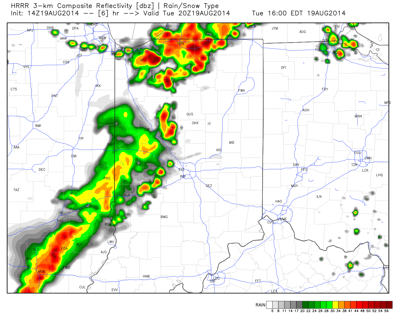
Compare that to the forecast radar from another one of our short-term, high resolution, forecast models, the HRRR, valid 6pm:

hrrr_ref_indy_2

(We want to thank the fine folks at Weatherbell Analytics for some of the forecast model images.  Additionally, thanks to Radarscope for the radar storm rainfall totals).

In closing, a combination of ingredients came together to present a localized, yet very significant flood event, for central Indiana.  The upper air pattern promoted movement of abnormally moist air to stream north into the Ohio Valley region.  At the same time, the same pattern resulted in a steering current that was relatively weak across our immediate region- adding to the potential of training.  The storms actually initiated (formed) along an old outflow boundary from the previous night, Wednesday, June 18th/ early morning Thursday, June 19th.

The days ahead will continue the unsettled theme across the region and we’ll have to remain on our toes for potential additional significant weather impacts as we move forward Friday, and even into the weekend.  Much more later.

Permanent link to this article: https://indywx.com/boone-county-central-indiana-flooding-61914/