Snow Showers Arrive Tonight…

Screen Shot 2016-01-03 at 9.45.06 AMHighlights:

  • Increasing clouds; snow showers tonight
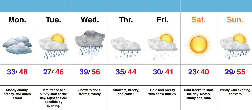
  • Calmer mid week
  • Next storm delivers rain late week
  • Significant cold outbreak looms

Cold Shot On Deck; Snow Showers To Develop…Our Sunday is dawning with sunshine across central IN, but we note a low cloud deck sinking south and this will engulf all of the region by afternoon.  Snow showers will begin to fall across the area by tonight and continue into Monday, and this is showing up well on our high resolution forecast radar, courtesy of Weatherbell.com.

MondayAMWe note the best chances of snow showers will favor the eastern half of the state as lake moisture gets involved.  Speaking of that, accumulations of a dusting to an inch will be possible across east-central IN with higher amounts north in the snow belt (3-6″ amounts with a Lake Effect Snow Advisory in effect).  You may want to leave extra travel time for your Monday morning commute.

Our mid week stretch will be dominated by a quiet couple of days as high pressure shifts east and we get into a return (milder) SW flow.

Source: Tropicaltidbits.com

Our next storm system approaches late week and will result in increasing cloudiness and showers developing by Friday, continuing into Saturday.

All eyes will then remain locked in on the 11th-13th time frame for potential wintry “mischief.”  There remain many more questions than answers concerning winter storm potential, but confidence continues to increase on a very cold blast of air around, or just before, mid month.  Stay tuned!

Cold, But Much Needed Sunshine…

Screen Shot 2016-01-02 at 9.49.21 AMHighlights:

  • Much needed vitamin D
  • Arctic air and scattered snow showers to open the week
  • Late week storm system
  • Big cold looms

Bright, But Chilly…High pressure will remain in control of our weekend weather.  Though it’ll be chilly, it’s great to see the sun shining (it does still exist, after all :-))!

We’ll be on the outskirts of an arctic intrusion Monday afternoon-Tuesday morning.  The brunt of the arctic air (single digits) will flow into the Northeast.  That said, we’ll also note a cold open to the week.  Scattered snow showers will accompany the reinforcing cold, as forecast radar below shows- courtesy of weatherbell.com.mondayAM

We’ll “relax” things a bit for mid week before we gear back up for a potentially active regime late week.  We’ll include showers in our forecast wrapping up the work week Friday.  You can read more here about our thoughts on next weekend.  Bottom line, it’s a low confidence forecast at this point.Jan112016

Rambling Around; Only A Couple Days Left In 2015…

December has been a warm and wet month for the region. In fact, it’s been so warm, some have labeled this “October in December.”       Snow and ice cover…

You must be logged in to view this content. Click Here to become a member of IndyWX.com for full access.  Already a member of IndyWx.com All-Access?  Log-in here.

Severe Weather & Record Warmth…

A very active weather day is in store for central IN.  As we type this (6:30 am), temperatures are hovering around 60 degrees.  Simply put, that’s hard to believe.  We’re on our way to a record warm day, with highs in the middle 60s across central IN.

The main story, however, will be the severe weather our area may have to deal with in (2) waves this afternoon/ evening.

The Set-up:  A short wave trough will eject out of the southern Plains into the Great Lakes region.  A surface low and associated cold front will accompany this trough.  Unseasonably warm and moist air will spread north this afternoon and evening, including surface dew points in the lower 60s.  PWATs (precipitable water values) will exceed 1.25″.

DewPoint

PWATThe Storm Prediction Center has expanded the Slight Risk of severe for all of the state, including an Enhanced Risk across southern IN.

Screen Shot 2015-12-23 at 7.15.53 AMTiming:  We think potentially (2) waves of storms will rumble through the state today.  The first likely comes during the early afternoon with a potential second line of storms blowing through the area in direct association with the cold front later this evening/ tonight.  Admittedly, it’s tough to pin point the second potential wave of activity until we see what/ how the first round of storms impact the local air mass.

*As always, the forecast radar products we show should not be taken verbatim.  These are used for guidance in building our forecast and provide a look at what the radar may look like during a given time frame.

2p forecast radar, courtesy of Weatherbell.com

Impacts:  We remain most concerned for the potential of damaging thunderstorm winds, but stress that we can’t rule out a quick spin-up tornado with this type set-up.

Most importantly, have a means of getting the latest weather information today, especially if you’re traveling.  Set those weather radios to alert you of any watches or warnings that may come later today.

Looking ahead:  We still forecast a significant rain event that will likely lead to flooding early next week.  Model data remains very consistent on the potential of 4″-6″ of rain over the upcoming 7-day period.  Afterwards, a blast of arctic air looks to invade to welcome in 2016.  More on both of these events after we deal with today’s severe.