We continue to sure up the forecast Saturday night and Sunday. Most all model data today began to trend southeast with our “follower” system, as expected. Past experience suggests the…
You must be logged in to view this content. Click Here to become a member of IndyWX.com for full access. Already a member of IndyWx.com All-Access? Log-in here.
You must be logged in to view this content. Click Here to become a member of IndyWX.com for full access. Already a member of IndyWx.com All-Access? Log-in here.
You must be logged in to view this content. Click Here to become a member of IndyWX.com for full access. Already a member of IndyWx.com All-Access? Log-in here.
A look over model data from overnight suggests we need to focus on a “leader-follower” event for the upcoming weekend.
We’re confident the “leader” player is a rain maker for IN in the Thursday afternoon-Friday time frame (.40-.70 rainfall potential).
Source: Tropicaltidbits.com
As we progress into the second half of the weekend, details get quite murky on the specifics with the secondary (follower) area of low pressure that develops along a pressing arctic front.
As we’ve been discussing, model solutions will vary within each respected model (GFS, Euro, GEM, etc.) in a run-to-run fashion. Stack them up against one another, and we’ll likely continue to have as many different solutions as we do models that we’re looking at. It’s a byproduct of a pattern transition and that crashing SOI (which is still crashing this morning, btw). Case in point, note the various options below for Sunday.
The GFS takes a low from southern AL into the coastal plain of NC. Source: Tropicaltidbits.comThe Canadian is a blend of the GFS and European as it tracks low pressure from eastern LA into the central Appalachians. Source: Tropicaltidbits.comThe European is most aggressive in the west track as it takes low pressure from the MO bootheel into northern IN. Source: Tropicaltidbits.com
Past experience with similar patterns certainly leads us to lean more towards the European/ Canadian solution over the GFS from this distance. We know that models have their own biases though. Time and time again the GFS bias is to rush things along a bit too much from this distance and become too progressive. On the flip side, the European is notorious for dragging it’s heels a bit and, at times, can be too slow with bringing energy out of the west. This in return impacts things downstream…
From this distance, we still can’t be too specific with snow/ precipitation prospects Sunday. While confidence is increasing on at least some sort of snow to contend with, the significance of such isn’t possible to iron out at the moment. Much fine tuning will be required. Stay tuned.
The first work week of the new year will feature us looking ahead to a significant period of cold around mid month. Additionally, we’re still trying to figure out the snow situation. While we’re not ready to pull the trigger on a southern stream event or high ratio clipper, it’s going to be tough to get out of this cold blast without some sort of snow. Those details we’ll become clearer as time draws closer.
A word of caution to those who watch operational data and want to iron out specific solutions in the 7-10 day range, you may want to stop (or have the dramamine handy). When the pattern is in states of major transition, model mayhem can ensue. Add in a crashing SOI and model output will continue to offer up a variety of solutions from run-to-run.
While we’re still not confident on how things unfold from a precipitation perspective in the Sunday-Monday time frame, we’re much more confident on the coming cold. What’s on the table is a day where we see lows around zero and highs in the lower teens. (Lay snow down and those numbers will drop lower).
The GFS ensemble is FINALLY coming around to seeing the arctic plunge. Source: Weatherbell.com
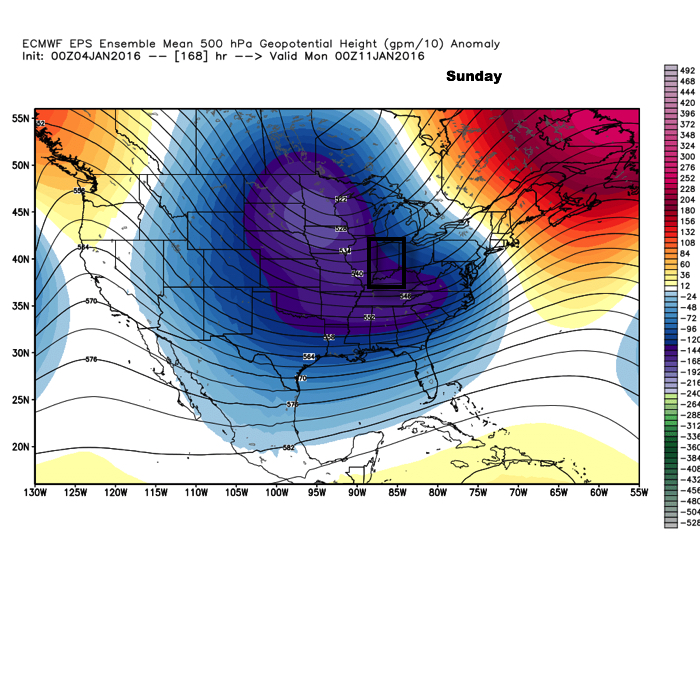
The European ensemble screams “trouble” with a leader-follower type scenario Sunday-Monday. We know Friday’s storm system is a rain maker for our area, but does a secondary push of energy lead to renewed storm development cutting through the Ohio Valley early next week? That’s what we’ll continue to monitor.
What do we know: That a significant period of cold arrives in the 13th-14th time frame. Depending on the snow situation, temperatures around zero can be expected for lows with highs in the lower teens.
Still trying to sort through the details: A lot is going on with our weather pattern right now and models will continue to struggle with storm specifics. Whether we see a southern stream system put us on the table for snow potential, or deal with fast-moving, high ration clipper systems remains unclear at the moment. Stay tuned.