Category: Rain
Additional showers will rotate through central Indiana during the overnight, followed by a colder mid week stretch. All eyes remain on the weekend for an impactful winter weather event across…
You must be logged in to view this content. Click Here to become a member of IndyWX.com for full access. Already a member of IndyWx.com All-Access? Log-in here.
Permanent link to this article: https://indywx.com/monday-evening-video-brief/
1.) Rain will spread into the state later this afternoon. Most folks will see 0.25″-0.50″. 2.) Colder air will filter into the region by the mid week period and help…
You must be logged in to view this content. Click Here to become a member of IndyWX.com for full access. Already a member of IndyWx.com All-Access? Log-in here.
Permanent link to this article: https://indywx.com/monday-morning-rambles/
|
Mon.
|
Tue.
|
Wed.
|
Thr.
|
Fri.
|
Sat.
|
Sun.
|
|

|

|

|

|

|

|

|
|
40/ 50
|
33/ 45
|
25/ 35
|
25/ 35
|
25/ 34
|
28/ 32
|
26/ 33
|
Highlights:
- Early Week Rain Maker
- Keeping An Eye On Mid Week
- Weekend Winter Storm For Some
Early Week Storm System…An area of low pressure will scoot though the Ohio Valley Monday into Tuesday delivering showers to the region. We forecast rain to arrive late morning to early afternoon Monday across central Indiana. We’re not expecting heavy rain, but plan on taking the rain gear with you as you leave for work and/ or school. Colder air will filter into the state Tuesday afternoon setting up a cold mid week period.
Some forecast models have hinted at the threat of light wintry precipitation Wednesday into Thursday, but for now we’re keeping this out of our official forecast and instead going with a mostly cloudy, but dry mid week period.
Developing Weekend Winter Storm…All eyes will focus on a significant weekend winter storm event. Details on track are still up for debate with this being in the mid range period and we’ll keep close tabs as we move forward through the week. As of now we forecast increasing clouds through the day Friday with light snow developing late Friday night and continuing into Saturday. Snowfall totals will obviously depend on the track of the low and we’re still a few days away from being able to provide any sort of specific accumulation ideas. Guidance right now ranges from a “plowable” event to one that misses us to the south and east. Stay tuned.
The weather pattern continues to look cold and active in the days leading up to, and through, the Christmas and New Year’s period. Buckle up for a fun ride…
Upcoming 7-Day Precipitation Forecast:
- 7-Day Rainfall Forecast: 0.25″ – 0.50″
- 7-Day Snowfall Forecast: 1″ – 2″
Permanent link to this article: https://indywx.com/busy-week-ahead/
Colts v. Texans Forecast Prepared For:
The Indiana Sports Report
12.14.14
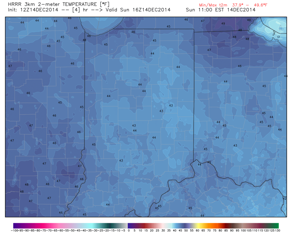
Happy game day Colts fans! – New day; same story…central Indiana will remain under the influence of an “inversion” and this will keep low clouds and areas of fog prevalent for most of the day. Milder air in the 50s at 4,000-5,000 feet up is overrunning shallow cooler air that’s trapped at the surface and the result in more of the same- gloomy, cloudy, foggy weather. While temperatures won’t be as mild as they could be without the inversion, tailgaters still can’t complain about 45-50 degree air this time of year :-). Visit IndyWx.com for “Indy’s Behind The Scenes Weather” all season long! Go Colts!
|
Tailgate Weather
|
Kickoff Weather
|
Heading Home
|
| Cloudy and foggy; patchy drizzle |
Cloudy with areas of fog; patchy drizzle |
Cloudy with areas of fog; patchy drizzle |
| Temp: 41-45 |
Temp: 46 |
Temp: 50 |
| Wind: S 5-10 MPH |
Wind: S 5-10 MPH |
Wind: S 5-10 MPH |
| Precip: Trace |
Precip: Trace |
Precip: Trace |

Despite low clouds and areas of drizzle, temperatures will be mild this morning for tailgaters!

Permanent link to this article: https://indywx.com/mild-foggy-with-areas-of-drizzle-for-colts-vs-texans/
|
Sat.
|
Sun.
|
Mon.
|
Tue.
|
Wed.
|
Thr.
|
Fri.
|
|

|

|

|

|

|

|

|
|
31/ 44
|
38/ 50
|
40/ 50
|
35/ 48
|
27/ 35
|
26/ 35
|
25/ 35
|
Highlights:
- Weekend Inversion
- Early Week Storm System
- Keeping Close Eyes On Next Weekend
Gloomy Weekend…Forecast models continue to suggest we deal with an inversion though the weekend and this will keep low clouds hanging tough along with areas of fog (be careful tonight into Saturday morning for areas of freezing fog). The warmer air is moving in aloft, but at the surface cold air remains hard to budge this weekend. Just think…if we could shake the low clouds and fog, temperatures would have no problem climbing well into the middle and upper 50s. Instead we forecast lower and middle 40s Saturday and upper 40s and lower 50s Sunday. Again, low clouds and areas of fog will hang tough, along with patchy drizzle.
Early Week Storm System…An area of low pressure will “bowl” across the middle of the country and result in developing showers late Monday, continuing into Tuesday. Temperatures will be too mild to support anything other than rain with our Monday-Tuesday system.
Colder; Eyeing Next Weekend…We’ll see a return of below normal cold for the second half of next week. Forecast models differ on Thursday’s solution and vary from a cold, dry day to one that features mixed rain and snow. For now, we’ll side with the dry theme for now, but suggest staying tune. A more “interesting” system awaits next weekend…
Upcoming 7-Day Precipitation Forecast:
- 7-Day Rainfall Forecast: 0.25″ – 0.50″
- 7-Day Snowfall Forecast: 0.00″
Permanent link to this article: https://indywx.com/weekend-inversion/


