VIDEO: Election Day Weather And Looking Ahead…
You must be logged in to view this content. Click Here to become a member of IndyWX.com for full access. Already a member of IndyWx.com All-Access? Log-in here.
You must be logged in to view this content. Click Here to become a member of IndyWX.com for full access. Already a member of IndyWx.com All-Access? Log-in here.
 Highlights:
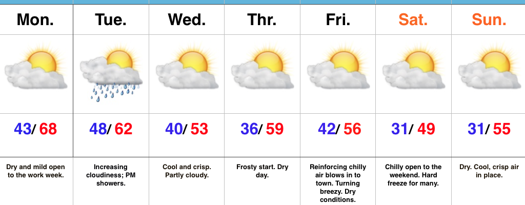
Enjoy Today; Changes Loom…High pressure will supply a beautiful open to the work week, complete with plentiful sunshine and highs close to 10 degrees above normal. Find a way to get outside and soak in this pleasant late-autumn weather!
A cold front will sweep through the state on Election Day. The day will open dry, but a band of light showers will move through the state during the afternoon-evening. This won’t be a big event and “light” is the key word. Chilly air will filter into the area behind the boundary for mid week.
Speaking of chilly air, the coolest air of the season thus far is slated for a weekend arrival. Winds will shift to the north Friday evening and help usher in the season’s first freeze for many by Saturday morning (some upper 20s can be expected away from the city). Dry conditions will remain this weekend.
Looking ahead, plenty of “fun and games” await by mid-month…
Upcoming 7-Day Precipitation Forecast:
You must be logged in to view this content. Click Here to become a member of IndyWX.com for full access. Already a member of IndyWx.com All-Access? Log-in here.
 Highlights:
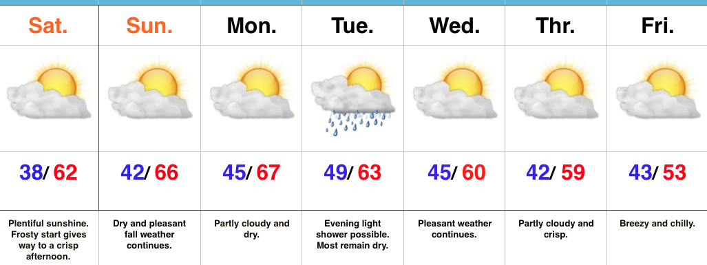
Lots Of Sunshine…Most folks around central IN woke up to the most widespread frost of the season so far. Many neighborhoods away from the city slipped into the middle 30s overnight. (It’s about time)!
High pressure will supply dry conditions through the weekend and into early next week. With crisp, dry air in place, it’ll feel mighty nice outside. Given what will likely be an increasingly “busy” (and cooler) second half of November, we’d recommend spending as much time outdoors as possible this week.
A weak frontal boundary will pass through central IN Tuesday night. Though the air mass will be very dry in front of this system, we can’t completely rule out the chance of a light shower Tuesday evening as the front moves through. (This won’t be a big deal).
Reinforcing chilly air will blow into town to wrap up the work week and early indications hint at the first freeze for many by next weekend.
The 2016-2017 IndyWx.com Winter Outlook has been posted and is available here.
Upcoming 7-Day Precipitation Forecast:
A rainy and (at times) stormy night is ahead for central Indiana as a cold front approaches.

While scattered thunderstorms are impacting portions of central IN as we type this (6p and looking at you Whitestown), more widespread showers and embedded thunderstorms will blow into town late tonight. Here’s an idea of what the radar may look like around 10p.

For most neighborhoods, expect 0.25″-0.50″ of needed rain tonight into the wee morning hours Thursday. There will be localized heavier totals through central Indiana.

Temperatures will be cooler Thursday, but will remain above normal- generally topping out in the middle and upper 60s in the afternoon before falling Thursday evening. Cooler air will be with us to close the work week (upper 50s to around 60° for most for highs Friday).

Our next storm system has it’s eyes on the area Tuesday evening into Wednesday, but looks less significant when compared to 24-48 hours ago. We’ll continue to keep an eye on things.
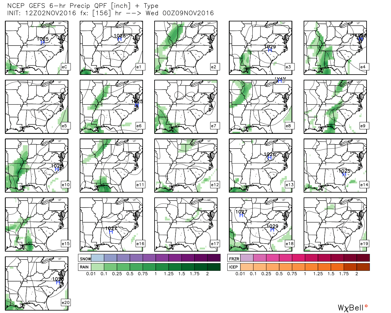
GFS ensemble members aren’t terribly “excited” about our next storm potential next week.
There continues to be a great deal of interest around colder times and a pattern change around mid-month. We want to reiterate a couple things:
1.) Wholesale significant pattern changes can (and normally do) wreck havoc on medium and long range data. To our fellow weather friends out there who love to look at run-to-run operational data, expect wild swings as the pattern transition gets underway mid month.
2.) While we’re fully in the camp of a major reversal to cold, we caution the initial pattern transition will likely feature a “step-down” process before shifting to more of a true winter-like pattern (likely complete with plenty of storminess; hello snow lovers) from the Thanksgiving to Christmas period.

Finally, our complete 2016-2017 IndyWx.com Winter Outlook can be found here.