VIDEO: More Active Times Loom…
You must be logged in to view this content. Click Here to become a member of IndyWX.com for full access. Already a member of IndyWx.com All-Access? Log-in here.
You must be logged in to view this content. Click Here to become a member of IndyWX.com for full access. Already a member of IndyWx.com All-Access? Log-in here.
 Highlights:
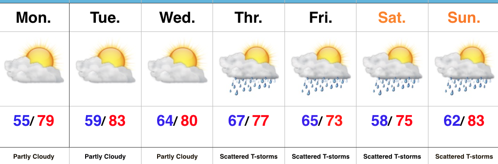
Week Opens Dry; Ends Unsettled…High pressure will remain in control of our weather as we open up the new work week. This will supply continued dry conditions along with a warming trend as our refreshing easterly flow transitions to the south.
This southerly air flow will help transport moisture northward as we progress into midweek and a “sluggish” front will begin to impact the area Wednesday evening into Thursday. Scattered showers and thunderstorms will develop and as the front meanders around the region, shower and thunderstorm chances will continue into the weekend. Forecast models differ on the evolution of things over the weekend and result in the sensible weather conditions ranging from more widespread showers and embedded thunder to more of a “splash and dash” variety of rain coverage. We’ll fine tune things as we progress through the week.
Much cooler air is forecast to return just past the current 7-day forecast period.
Upcoming 7-Day Precipitation Forecast:
 Highlights:
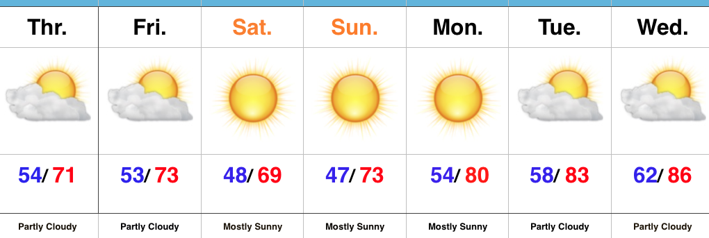
This Is More Like It…Cooler air worked into central Indiana overnight behind a cold front. If you ask us, a step out the door this morning feels much better than the past week (we’re ready for fall, y’all)! A reinforcing push of cool air will blow into town Friday evening and result in Saturday being the coolest day of the weekend with most remaining in the 60s for afternoon highs.
As we open up the new work week, our air flow will back around to the south and result in a new warming trend. An expanding ridge of high pressure will lead to continued dry conditions next week, along with unseasonably warm to hot temperatures.
Looking longer-term, there’s really no change in sight in the overall weather pattern through at least early October. That said, there are indications more significant changes loom towards mid-month that could result in more of an impactful shift to cooler times by the second half of the month (warm weather fans, keep in mind the other shoe has to drop sooner rather than later ;-)). As far as precipitation goes, while the short-term doesn’t offer any hope for dry weather relief, we’re confident of a big flip towards a wet pattern by late autumn and winter. Hang in there!
Fall Foliage: The early season cool air we experienced in late August and first half of September ignited early fall foliage across central Indiana. Unfortunately, the recent heat and expected warmer than average pattern through early October will really stunt that fall color change. As things stand now, this fall isn’t shaping up to be one of the better color seasons across the area.
Upcoming 7-Day Precipitation Forecast:
You must be logged in to view this content. Click Here to become a member of IndyWX.com for full access. Already a member of IndyWx.com All-Access? Log-in here.
 Highlights:
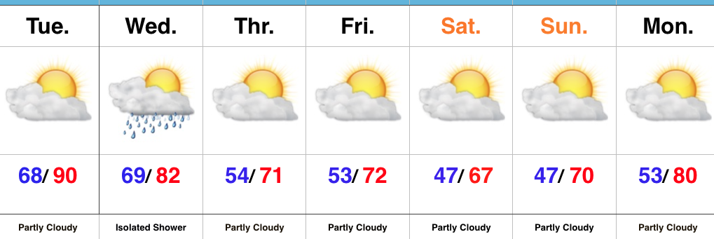
Cooler Air Inbound…We have one more sultry day to get through as highs near record territory Tuesday with partly cloudy conditions prevailing. A frontal boundary will slip through the state Wednesday, but moisture will be limited with the frontal passage. If you pick up a quick shower Wednesday count yourself lucky. Most will remain rain-free. Cooler air will then settle into the state as we head into the weekend. If you have plans to head out to the pumpkin patch or apple orchard, ideal autumn weather will greet you!
Looking ahead, a new warming trend will develop next week and there’s no significant rainfall in sight, unfortunately.
Upcoming 7-Day Precipitation Forecast: