Active Weather Pattern Remains; Much Cooler To Close June…

Highlights:

  • PM storms
  • Dry midweek
  • Wet close to the work week
  • Much cooler air looms

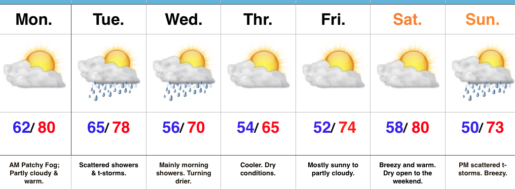
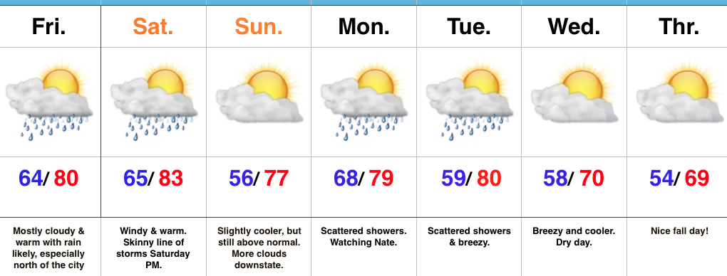
Busy Times…Upper level energy and just enough instability could spark another round of scattered showers and thunderstorms this afternoon and evening.  Similar to Monday, these will be quick-movers, but shouldn’t be quite as strong as yesterday.

Dry weather will return through midweek and while pleasant air will still be with us Wednesday, a more humid feel will develop Thursday.  Showers and thunderstorms will begin to creep back into the picture Thursday downstate, but we believe most of central Indiana should remain rain-free.

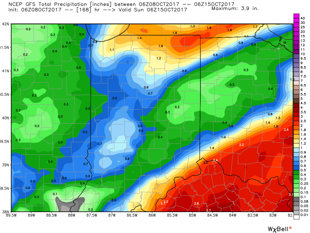
We’ll be in a “squeeze play” of sorts to close the work week and head into the weekend.  A cold front will drop in from the north while remnant tropical moisture moves north out of the Deep South.  Widespread showers and thunderstorms should result, including the potential of locally heavy rain.

The big story over the weekend into the last week of the month will be unseasonably cool air.  Enough upper level energy will be around in a fast northwest flow aloft to lead to shower chances Sunday, otherwise early next week looks stunning- including plentiful sunshine, dry air, and unseasonably cool temperatures.

Upcoming 7-Day Precipitation Forecast:

  • Snowfall: 0.00″
  • Rainfall: 1.00″ – 1.50″

Refreshing Open To The Week; Scattered Storm Chances Remain…

Highlights:

  • Feelin’ nice
  • Scattered storms remain
  • More widespread storms late week

Pleasant Open To The Work Week…A step out the door this morning will reveal a much more pleasant feel than what we’ve grown accustomed to over the past week, or so.  Much lower humidity and cooler air will be with us through the day Tuesday.  With that said, enough upper level energy will be nearby to spark afternoon and evening showers and embedded thundershowers both today and Tuesday.

Humidity will return for the midweek stretch, and temperatures will also be on the climb.  While the weekend looks unsettled, the precise details remain a bit “murky” at this point.  We know a cold front will slice into the warm and humid air mass, which will serve as a trigger for more widespread showers and thunderstorms (some with locally heavy rain).  Some model guidance wants to get tropical moisture involved (from whatever comes of what’s currently Invest 93L). Stay tuned as we continue to look over the data this week.  Regardless, a much cooler and drier air mass will arrive next week…

Upcoming 7-Day Precipitation Forecast:

  • Snowfall: 0.00″
  • Rainfall: 1.00″ – 1.50″

JMA Weeklies: Heat Relief Coming And An Active Pattern As We Get Into July…

The new JMA Weeklies are in and highlighted by the following:

  • Heat relief on the way through Week 1
  • Core of heat, relative to normal, backs west through the period
  • Active NW flow regime to open July

Week 1:  

The JMA Weeklies really try to emphasize the “transient” nature of the pattern and associated dry, hot weather some folks were becoming concerned about only a couple of days ago.  Week 1 is highlighted by a much wetter regime through the Ohio Valley and most of the East.  As the ridge pulls back west, a cooler regime returns to our region, while the Southwest bakes with anomalously hot weather.

Week 2:  

The pattern favors wetter than normal conditions across the upper Mid West, including Great Lakes.  The mean upper ridge is forecast to remain out west.  Fittingly, the warmest temperatures, relative to average, will be confined to the west.

Weeks 3-4:  

As we push into July, the upper pattern sets-up in a manner that will require us to keep a very close eye on storm potential.  With a northwest flow aloft, we’ll have to be mindful of the potential of storm clusters impacting the region- tracking northwest to southeast.  Through the balance of the period, the hottest weather should remain to our west, relative to normal.

Model Data Remains Consistent On A More Active Pattern Returning…

Today’s 12z model suite is in and it remains consistent on a more active weather pattern returning to the delight of many Hoosiers! A blend of the GFS and European 10-day rainfall numbers print out 2″ for Indianapolis.  The GFS ensemble ‘mean’ (a blend of 21 individual members) agrees.

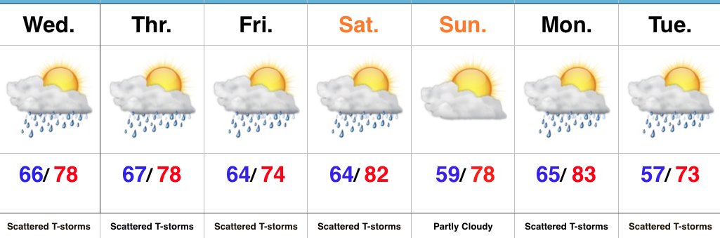
Best overall coverage of showers and thunderstorms should come in (3) waves over the upcoming 10-day period:

  • Wednesday into Thursday
  • Saturday into Sunday
  • Middle parts of the following week

While we don’t see any sort of uniform type rains in the upcoming period, the “smattering” of storms should help most neighborhoods get in on the rainy “goods” at one time or another over the upcoming week and a half.  Keep in mind, we’re in mid-June now and it’s mighty difficult to ask for anything much more than scattered storms this time of year on through late-summer…unless a tropical entity gets involved.  That’s just the way this time of year is.  With that said, localized torrential downpours are a very good bet from time to time, beginning as early as mid-week, as precipitable water values approach, or exceed, 2″ (about as moisture-rich as you can ask the air mass to get around these parts) into the upcoming weekend.

As I type this outside on the back porch this evening, I hear the sounds of sprinklers in full-force through the ‘hood.  Thankfully, Mother Nature will help save on the water bill later this week.  Longer-term, you’ll hear us use the word “transient” many times this summer when discussing the overall weather pattern.  Thankfully that tends to result in a fairly busy time of things.  Before you know it, college football season will be back (83 days until my beloved Auburn Tigers kick-off), those wetter autumn storms will return, and thoughts will begin to shift to winter (they may have already started here :-))- not that we’re trying to rush summer away or anything…