VIDEO: Closing Out June And Heading Into July…
You must be logged in to view this content. Click Here to become a member of IndyWX.com for full access. Already a member of IndyWx.com All-Access? Log-in here.
You must be logged in to view this content. Click Here to become a member of IndyWX.com for full access. Already a member of IndyWx.com All-Access? Log-in here.
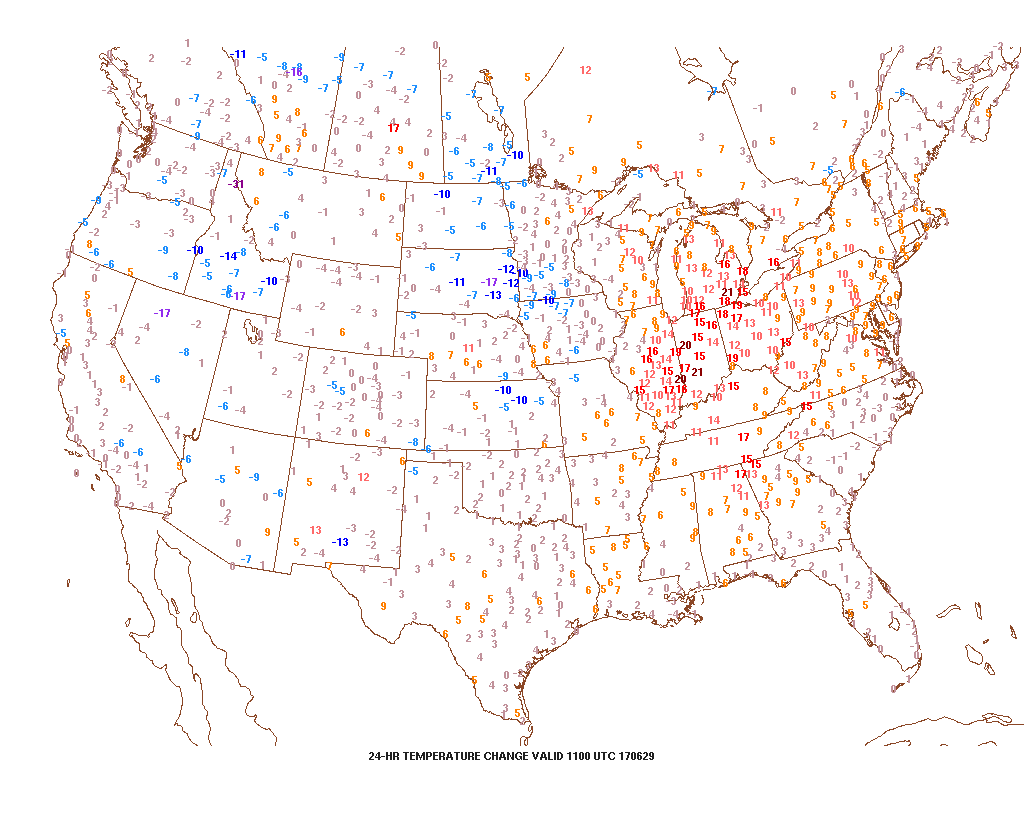
1.) Temperatures are running much warmer across the Mid West and Ohio Valley this morning. In most cases, communities are 15° to 20° ahead of this time 24 hours ago. Ah, the fall-like feel was nice while we had it!
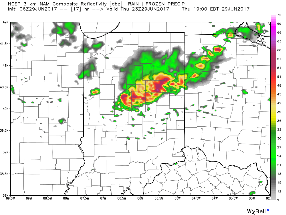
 2.) With the increasing warmth and humidity will also come an increase in shower and thunderstorm chances today through Saturday. Most widespread coverage of thunderstorms should occur during the evening hours today and Friday night into Saturday morning. Drier air will try and work in Saturday afternoon into Sunday. Here’s a look at the forecast radar valid at 7p this evening.
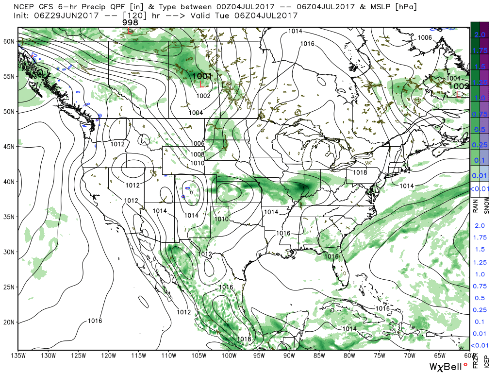
 3.) While we should dry things out Saturday afternoon into Sunday, active times will return early next week. We’ll have to fine tune timing, but the period Monday into Independence Day may feature a rather strong storm complex moving in a southeast fashion across the region. Again, details still have to be determined. While strong storms are possible at some point during the period, more dry time than wet can be expected.
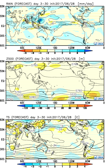
 4.) The latest JMA Weeklies are in and while we’ll have a more extensive post this evening on the weekly breakdown, the screaming message to us is an active period continues along with cooler anomalies setting up shop across the central, including our region.
 Highlights:
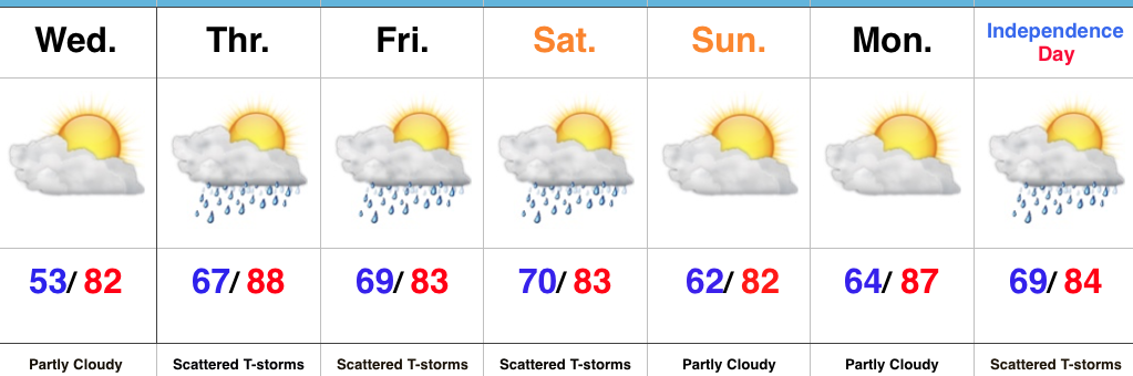
Unsettled Weather Looms…We’ve got one more pleasant day to enjoy, but take advantage of it as changes for a more tropical-feel loom. With that increasingly warm and moist air, we’ll also see an increase in showers and thunderstorms as we wrap up the week. While it won’t rain the entire time, a couple rounds of strong-to-severe thunderstorms are possible during the Thursday afternoon-Friday period.
We think we return to drier conditions late weekend into Monday, but this drier theme likely won’t hold through the holiday period. Scattered showers and thunderstorms return by Independence Day.
Upcoming 7-Day Precipitation Forecast:
 Highlights:
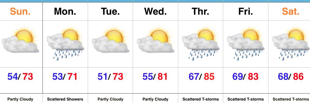
Beautiful Weather Continues…To help put this weather into perspective- our average low and high in late September falls in the lower 50s with highs in the lower to middle 70s. For the next few days, an early fall-like feel will grip central Indiana, and you won’t hear many folks complaining about it! (Personally, I say let’s skip right to those crisp late September days and football season :-))! Despite a weak upper level disturbance creating a shower chance Monday, we’re dry through midweek.
A return southwesterly air flow will arrive on the scene by late week and this will serve to help boost temperatures and humidity levels, along with assist in creating a better chance of scattered to numerous showers and thunderstorms late week into next weekend. Let yours truly worry about that and you be sure to enjoy this rare late June air!
Upcoming 7-Day Precipitation Forecast:
 Highlights:
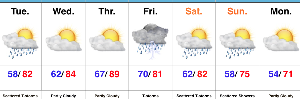
Busy Times…Upper level energy and just enough instability could spark another round of scattered showers and thunderstorms this afternoon and evening. Similar to Monday, these will be quick-movers, but shouldn’t be quite as strong as yesterday.
Dry weather will return through midweek and while pleasant air will still be with us Wednesday, a more humid feel will develop Thursday. Showers and thunderstorms will begin to creep back into the picture Thursday downstate, but we believe most of central Indiana should remain rain-free.
We’ll be in a “squeeze play” of sorts to close the work week and head into the weekend. A cold front will drop in from the north while remnant tropical moisture moves north out of the Deep South. Widespread showers and thunderstorms should result, including the potential of locally heavy rain.
The big story over the weekend into the last week of the month will be unseasonably cool air. Enough upper level energy will be around in a fast northwest flow aloft to lead to shower chances Sunday, otherwise early next week looks stunning- including plentiful sunshine, dry air, and unseasonably cool temperatures.
Upcoming 7-Day Precipitation Forecast: