Shift Back To A Cold Pattern Awaits; What About Winter Storm Potential?
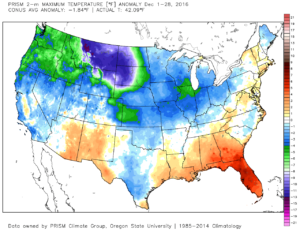
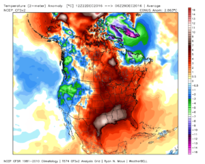
December-to-date is running colder than normal (to the tune of 2.2 degrees at IND), but the past (7) days has seen a flip in the frigid 1st half of the month.
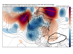
The “relaxation” is temporary. Modeling continues to advertise the recent “thaw” will give way to increasingly bitter times as we get deeper into the New Year. By New Year’s Day we note the positive heights continuing to establish themselves across Alaska and Greenland (cold and stormy signal). We also note the southeast ridge present, though to a lesser degree than over the past week.
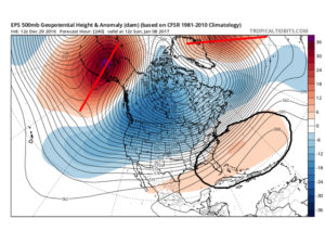
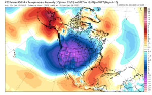
 By Day (10), the cold pattern is well established over the Lower 48. This is a coast-to-coast cold signal (heart of the cold centered over the west and central) depicted by the European ensemble, along with other modeling.
 Teleconnections support a cold pattern returning.
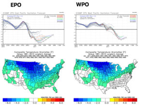
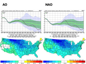
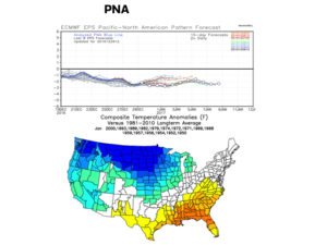 The agreement amongst teleconnections is nice to see and ups confidence in the overall direction of where this pattern is heading in regards to colder than average times looming. The negative PNA correlates nicely with the SE ridge that continues to make itself heard from time to time over the next few weeks. It should also be noted that the phases of the Arctic Oscillation (AO) and North Atlantic Oscillation (NAO) become more of a factor for mid and late winter.
As far as storminess goes, we’ll have to handle those as they come. The overall pattern screams towards the idea of an active Ohio Valley to interior Northeast storm track as we move forward (continuing deeper into mid and late winter, as well). That doesn’t mean one or two storms won’t bypass our local region to the south, due to strong, cold high pressure north, but the mean storm track should put areas through the Ohio Valley in the “sweet spot” from a snow perspective throughout the majority of January, and the rest of winter, for that matter. Depending on the position and strength of the Greenland Block will have a lot to say about things. Needless to say, storms cutting NW into the central Lakes should be few and far between after the New Year. Speaking of storms, we have to continue to keep an eye on the second half of next week. At the time of this discussion, the threat is still beyond the 7-day period, but circle late next week and weekend for the potential of wintry “mischief.”
 Speaking of warmth, 2016 has been a very warm year.
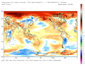 (The cold of 2014 seems so long ago…)
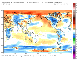 Back to present. We’ve targeted the middle part of November to finally beginning “bucking” the recent warm trend. This won’t happen overnight and will be a battle of back and forth, initially. Thus, the “step-down” label. To be clear, November, as a whole, will finish much warmer than average. It’s virtually impossible to counter the incredibly warm start. That said, we do anticipate “jabs” of colder air working in here over the next couple weeks. For instance, this weekend will feature lows in the 20s for most and highs not making it out of the 40s Saturday afternoon. (The average low and high at IND Saturday are 37 and 54).
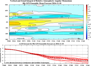 When we look at the AAM forecast (above), we note the westerlies may begin to slow (indicative of the negative values) in the 8-10 day period. This is crucial and, simply put, has to happen for the pattern to begin shifting into more of a position to allow sustained cold to enter the equation. We want to reiterate that this, in and of itself, doesn’t create the cold, but instead allows the pattern to begin shifting away from the Nino-like (warm) regime into more of a La Nina pattern, as a whole. – Hey, you have to start somewhere.
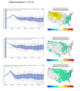 Additionally, the EPO is forecast negative off the GEFS and EPS. (Images courtesy of Weatherbell.com).
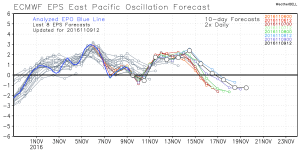
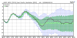 Again, this is a cold signal. (Image courtesy of Madusweather.com).
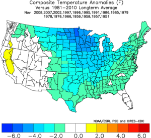 The ensemble data is also beginning to key-in on higher heights (blocking) developing over the top. Notice the significant changes in the overall look to the pattern between now and days 11-16. (Images courtesy of Weatherbell.com).
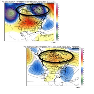 In summary, and in the face of *most* seasonal data that is screaming warm, warm, warm, we still don’t have any significant changes to our overall thinking of “step-down” mid-November giving way to more sustained wintry-like conditions in the overall sense from the Thanksgiving-Christmas period. Time will tell and only the Good Lord knows what the future holds, but we’ve done far too much work and research to throw the “game plan” in the trash before the game even begins…