Iron Bowl Saturday: December Rambles…

This is a special day in the McMillan house.  Iron Bowl Saturday only comes around one day a year… Needless to say, the Auburn flags have been on the vehicles since Wednesday, we’re decked out in our orange and blue, and game faces are on for this evening’s matchup.  WAR EAGLE!

As we get set to flip the calendar to December, we wanted to post some latest thinking.

Let’s take a look at the latest teleconnections.  As we’ve been talking, there’s a lot of “noise” in model land, including conflicting signals.  The positive NAO and AO argue for warmer than average conditions, while the positive PNA suggests chillier than normal times should prevail.

We wanted to post the latest model predictions of each teleconnections, courtesy of Weatherbell.com.  Additionally, courtesy of madusweather.com, here’s what each teleconnection “phase” would normally lead to in December.

NAO

Screen Shot 2015-11-28 at 10.55.21 AMNAOpos_12dec

AO

Screen Shot 2015-11-28 at 10.55.07 AMAOpos_12dec

PNA

Screen Shot 2015-11-28 at 10.55.34 AMPNApos_12decSimply based on the teleconnections, you would build a December forecast that would lean more warm than cold, as the short term positive AO and NAO should trump the positive PNA.  As we look at the month, as a whole, the AO and NAO are forecast to trend more neutral, while the PNA remains solidly positive.  Does this suggest colder air, relative to normal, would invade mid and late month?  – Certainly something to watch.

Additionally, the latest Southern Oscillation Index (SOI), has begun to take a negative hit.  This is after weeks of positive SOI values- relative to the base state.

Screen Shot 2015-11-28 at 10.47.52 AM


While it takes a while to impact the pattern, locally, this negative hit does suggest mid and late month could be a bit more interesting from a wintry perspective.  We shall see.

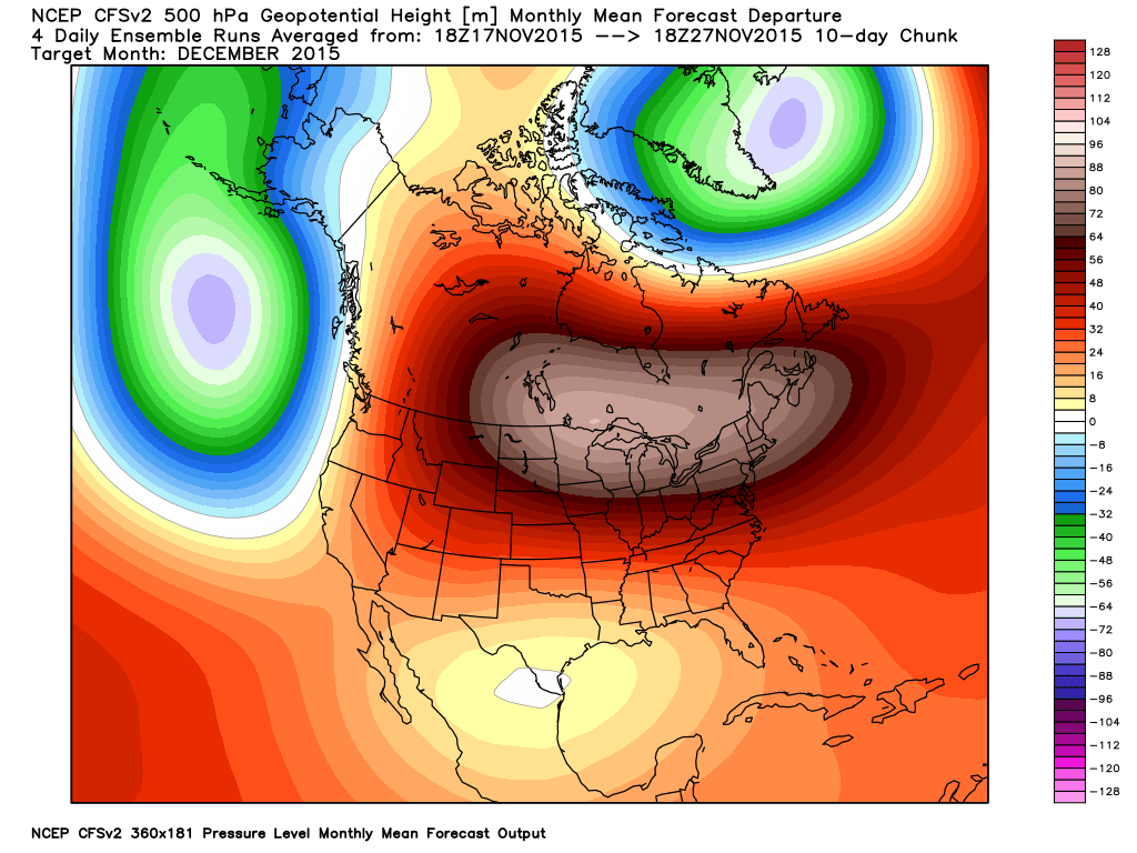
The CFSv2 remains very consistent on a warm month, relative to normal, particularly across the northern tier.

cfs_anom_z500_noram_201512_w3cfs_anom_t2m_noram_201512_w3


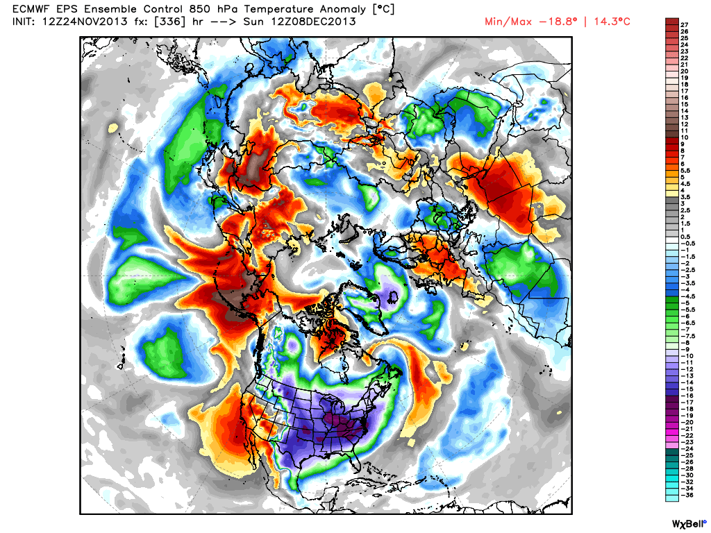
While we can’t post the European weeklies here, the latest run suggests colder, and stormy times around Christmas week.  Now, we should also note the overall performance of the Weeklies hasn’t been as accurate compared to normal over the past few months, but it’s another interesting trend to keep an eye on.

The MJO will begin the month in Phase 3 before going into the “wheel house.”  All-in-all, we don’t get a “hat tip” from the expected monthly MJO forecast, with the exception of Phase 3 to begin (warm phase).

EMON_phase_MANOM_51m_full

Screen Shot 2015-11-28 at 11.53.45 AMTo sum up:  Long range forecasting is always a gamble.  Only the good Lord knows what the future holds.  That said, there are times when we feel more confident about our long range, monthly outlooks, more so than normal.

We’ll lean warmer than normal for December (+ 1.5 at IND), and this really plays into our Winter Outlook (slow start expected with the emphasis on the cold and snow mid and late winter), but that doesn’t mean we’re expecting a “boring” month.  Keep in mind November has been both warmer AND snowier than normal, with a very busy 2nd half of the month.

We’ll have plenty of challenges to handle as we rumble through the month no doubt, but we expect the positive AO and NAO to trump the positive PNA to start to the month.  As we progress into mid and late month, we’ll have to be on alert for potential impacts of that significant SOI hit to open the month.  We’ll also keep the Weeklies in check to see if the colder, stormy look Christmas week remains.  It’ll be fun, as always.

To close, here’s one more emphatic WAR EAGLE from our home to yours! 🙂

Warm Up Coming…

After a long and cold winter, many are excited about hearing of the prospects of a warm up and first true taste of spring.

While the European data has totally bought in to the impressive “spring fling” next week, the GFS isn’t as excited of the potentially warmer times.  Case in point, the GFS and European couldn’t be in more different camps for mid and late next week.  Where the GFS has low/ mid 40s for highs the European has low/ mid 60s for highs.  What’s 20 degrees amongst friends?!

Wild model swings and disagreements are common when pattern changes are taking place.   While we might not get as warm as the Euro. would imply, it’s a safe bet we’ll be considerably warmer than the chilly GFS readings.

Note the AO and NAO strongly positive through the next 10-15 days.  This is the time of the year when these teleconnections can impact our region’s weather in the most significant way.  Both of these are warm signals taken at face value.

3


4


Note the pattern flip to a “flat” ridge by Day 10, indicative of the milder times ahead.

1


However, by Day 15 we notice the Alaskan ridge redeveloping.  This is NOT a signal for warm weather across our part of the region, as the steering currents would tap available cold air and direct it south into the Mid West and Ohio Valley.

1


So, what do we take from this?  We’re going to warm next week without question.  While the extent of the warming is up for debate, the overall milder times for a 5-7 period is a good call at this point.  On the flip side, we’re not ready to buy into the idea that spring is here for good just yet.  The building Alaskan ridge by the end of Week 2 would imply a cold close to March, and potentially continuing into early April.

Another item to keep a close eye on the upcoming 4-6 weeks?  Those NAO and AO signals.  Should they remain predominately positive this time of year then it’ll be exceptionally challenging to get any sort of cold pattern to lock in for more than a day or two.

Facts Are Facts…

I’m hearing rumblings out there that you can’t get sustained cold across Indiana without a negative Arctic Oscillation (AO) and/ or negative North Atlantic Oscillation (NAO).  I would ask those with that belief to please explain the following:

January temperature anomalies month-to-date show widespread cold (even accounting for the January thaw the past week).

ncep_cfsr_noram_t2m_anom


The first two weeks of the month were downright frigid and this was in the face of an AO that was not just positive, but strongly positive.

AO

To take this a step farther, the recent relative warmth has come with a negative AO.

Bottom line is that a ton of drivers are trying to take the wheel this winter.  Admittedly, that makes things incredibly difficult for forecasting- short-term or longer range.  That said, coming out with a “blanket statement” that you can’t have sustained cold without a negative AO or NAO is a flat-out lie and we wanted to address it.  Teleconnections can help many times with coming weather patterns, but not always.  This winter is a prime example of that.

Quick note on the clipper system- all forecast models today have taken the primary impacts (at least from a snow standpoint) north of the immediate region (central Indiana). Heaviest snows are favored across the Great Lakes, extending down into northern IN. We’ll continue to keep a close eye on things…

Major Storm Brewing This Weekend, But Details Are Murky…

During the late summer and early autumn months we were trying to look at the big picture and potential drivers in the overall weather pattern for the upcoming winter and openly admitted the challenges that were ahead.  Here we are now into the second half of December and a much colder and snowier-than-average month is a virtual lock at this point.  Furthermore, consider this has all taken place without the presence of a favorable NAO or PNA.  Sometimes you have to look for other drivers in a pattern- in this case, the EPO, as well as a growing early fall snow pack across the border to our north.  Additionally, we made mention of the likelihood of a southeast US ridge periodically making itself known through the winter of ’13-’14.  You can read all of our thoughts posted earlier this fall here, or by clicking the Thoughts On Winter ’13-’14 page above.

As we look ahead towards the upcoming wintry challenge, we’re confident of the overall pattern, but the sensible weather that’ll ensue is still up for great debate.  “Gut” tells me central Indiana will be looking at a rain to freezing rain scenario, but this is far from set in stone, and sometimes forecasters who go simply off their instinct can get burned.  The pattern is one that (once again) will feature a pressing arctic front against resistance from the southeast US ridge.  With this type of scenario, I would advise against looking at each and every individual operational model run, but instead invest time studying the ensembles- an average of several multiple model runs as opposed to just one operational model run.   I can guarantee a variety of wild solutions ahead in the days to come, based off the operational runs. (Heck, just the past 24 hours have been reason enough to have the dramamine on hand :-)).  That said, let’s take a look at the latest GFS and European ensembles, two models that we rely heavily on in the mid range weather pattern.

First, the GFS, valid Saturday through Monday.

f120f144f168

Now, here’s a look at the latest European ensembles (left), again valid Saturday-Monday.

Geopotential32at32500hPa_North32America_120Geopotential32at32500hPa_North32America_144 Geopotential32at32500hPa_North32America_168

So what do all of these cool maps tell us?  Simply put, that “wintry mischief” is brewing for the weekend.  That much we know, but the details have to be ironed out.  It’s likely heavy snow and a significant ice storm looms for some of the Mid West and Ohio Valley for the upcoming weekend.  Is that Indianapolis or Chicago?  Perhaps in between?  It’s too early to know.  Additionally, in the “warmer” sector, heavy rains are likely to combine with an impressive early season snow pack for some to lead to flooding concerns.

A couple of additional items to note. Many times at this stage in the game (still 5+ days out) with this type of pattern, forecast models really struggle with handling low level cold air.  Cold air is very dense and, in this type of set up, can easily drain much further east and south than forecast at this juncture.  Additionally, sometimes the modeling can put too much “umph” into the associated surface wave that moves along the arctic front resulting in a further north track than what may actually occur when the event draws closer.  Just something to keep an eye on as we draw closer…

Needless to say, it’ll be particularly important to keep a close eye on the developing weekend forecast as we move forward.  It’s likely folks in the Ohio Valley region have to deal with significant precipitation amounts in the Saturday-Monday time period, including rain, freezing rain, and snow.

Data Suggests Cold Pattern Keeps On Keepin’ On…

As we approach the all-important holiday travel season, I thought it would be nice to review what some of the data suggests in the long range sense.  While nothing is “set in stone” talking about weather 2-3 weeks out, we feel pretty confident in the overall idea of a colder than normal pattern and one that’s also potentially wintry- from a precipitation perspective.  The specifics with each storm will have to be handled as they come.

Let’s look at some of the data.  BTW, I want to give full credit to the awesome model suite that can be found at Weatherbell Analytics for some of these images.  Be sure to check them out at weather bell.com.

First, we’ll take a look at the Canadian ensembles, centered on the 8-16 day period.  Note the tongue of cold coming out of western Canada, extending southeast and encompassing the Ohio Valley region.  Folks, this is significant cold forecast off the Canadian ensembles as temperatures are suggested to average 5-7 degrees (C) below normal.

can_t2m_mean_conus_d8_16


The latest GFS ensembles also suggest widespread colder than normal temperatures over the upcoming couple weeks.  Similar to the Canadian (above), the GFS suggests temperatures average 5-7 degrees celsius below normal.

gefs_t2m_mean_noram_d0_16


Latest European ensemble data suggests a cold look as well, but one that also may feature a day or two above normal (over the next couple weeks). The latest ensemble control run highlights the threat of some bitterly cold arctic air plunging south towards the second week of December (posted below).  We’ll continue to monitor this in the days to come.

eps_t850a_c_nh_57


Here’s a look at the latest CFSv2. While it’s in stark contrast to only a couple of weeks ago (in its December forecast), the model is now onboard with most other data in forecasting a colder than normal December for our region.

CFSv2.NaT2m.20131124.201312


It has to be pointed out that all of the cold data is forecast during a time where the three “major” teleconnections really aren’t in the most ideal spots for eastern cold.  Typically, cold lovers across the eastern United States want a negative AO and NAO with a positive PNA. The NAO and AO are forecast to be very “sporadic” over the course of the upcoming 7-10 days while the PNA is forecast to go back negative.  That said, the NAO has the biggest influence on our weather from January through March (we’ve covered this in posts in the archives).  The expansive early season snow and ice pack through western Canada is having it’s say with a couple of early season “brutal” cold shots here (it’s very rare to get this kind of cold so early in the season).  We’ll continue to monitor these teleconnections moving forward for any sort of a more defined signal that may begin to come to fruition.

Speaking of snow and ice cover; look at how much more territory across the Lower 48 is covered with snow and ice compared to this date (November 24th) last year.  Impressive, huh?

November 24, 2012 (11.8% covered in snow)

nsm_depth_2012112405_National

November 24, 2013 (37.8% covered in snow)

nsm_depth_2013112405_National

As we look closer at the near term, there’s a chance of some light snow moving in Monday evening (not a huge deal, but some light accumulations of a dusting to half an inch are possible).  Scattered snow showers will also blow into central Indiana Wednesday as a reinforcing shot of fresh arctic air blows in prior to Thanksgiving.

In the mid range, both the GFS and European ensembles (below) suggest an “intriguing” look for the first 10 days of December for the potential of a more widespread winter weather maker.  It’s far too early for details, but with arctic air being supplied into a pattern that looks to have a southern branch beginning to flex it’s muscle, we’ll have to remain on our toes as we go into December…  Here’s wishing you a very happy and healthy Thanksgiving, complete with safe travels!

Geopotential32at32500hPa_North32America_240gefs_z500anom_nh_65