You must be logged in to view this content. Click Here to become a member of IndyWX.com for full access. Already a member of IndyWx.com All-Access? Log-in here.
Category: Heavy Rain
Permanent link to this article: https://indywx.com/2018/09/05/video-much-cooler-wet-and-blustery-weekend-on-deck/
Sep 04
VIDEO: Gordon’s Remnant Moisture Arrives To Close The Week…
You must be logged in to view this content. Click Here to become a member of IndyWX.com for full access. Already a member of IndyWx.com All-Access? Log-in here.
Permanent link to this article: https://indywx.com/2018/09/04/video-gordons-remnant-moisture-arrives-to-close-the-week/
Sep 04
Gordon’s Remnants Deliver A Wet Weekend…
This morning, Tropical Storm Gordon continues to churn in the central Gulf of Mexico. Gordon should make landfall late tonight or very early Wednesday morning along the AL/ MS Gulf Coast as a strong Tropical Storm or minimal Hurricane.
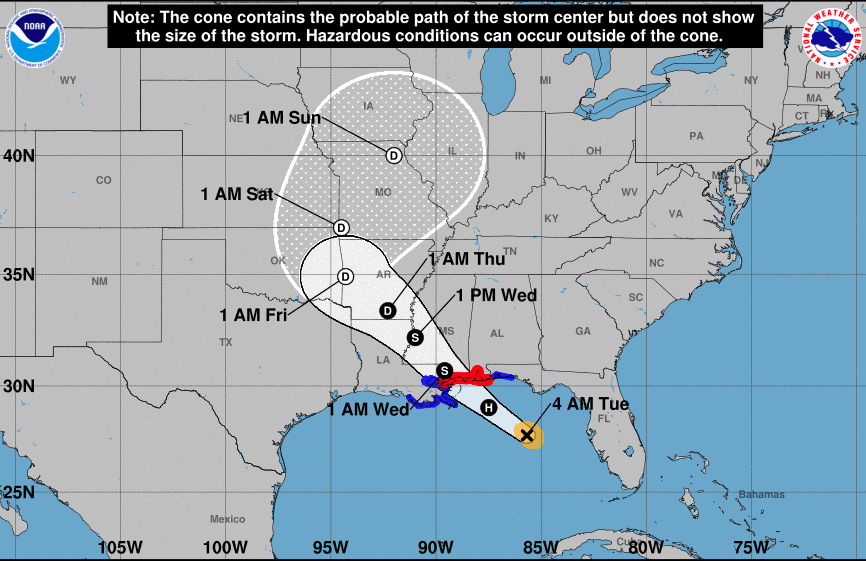 Mostly dry, hot, and humid weather will continue to gain headlines, locally, through midweek. Thereafter, a combination of ingredients spell for unsettled times late week and a rather wet weekend.
- Remnant moisture of Gordon will “curl” around the periphery of an upper level ridge to our east
- A “wavy” frontal boundary will drop south into the Ohio Valley this weekend, entraining the remnant tropical moisture

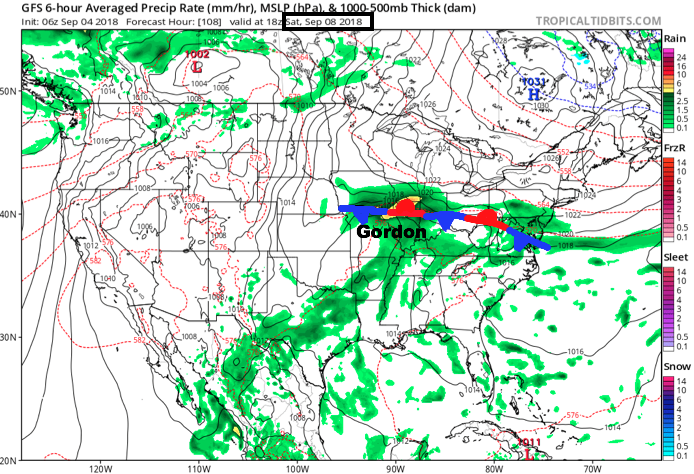
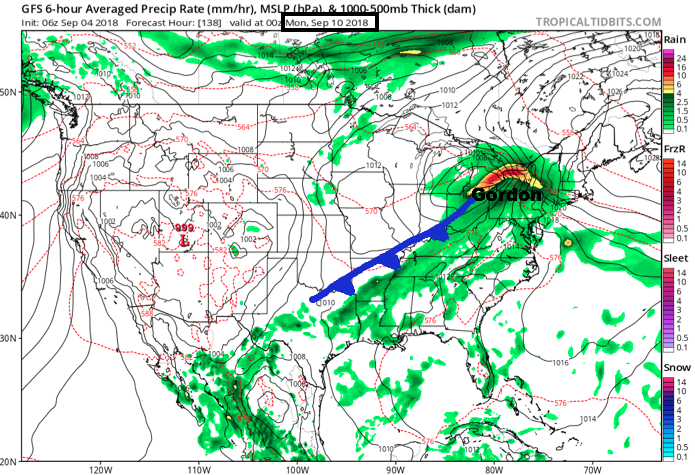 Eventually, Gordon’s remnants will track into the Northeast Sunday night into Monday and will allow the stationary front to sweep through the Ohio Valley. This will provide a drier air mass as we open the new work week.
Beforehand, precipitable water values will exceed 2″ at times this weekend, in association with Gordon’s remnants, and this will promote periods of heavy rain. As things stand now, most widespread heavy rain is expected to arrive Saturday, but it’s a safe bet to plan for wet weather Friday through Sunday.
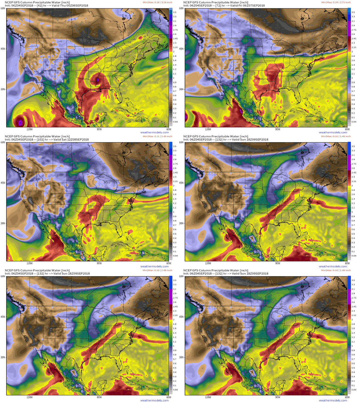 Widespread 1″ to 2″ rainfall totals are expected this weekend across central Indiana, including locally heavier amounts.
Permanent link to this article: https://indywx.com/2018/09/04/gordons-remnants-deliver-a-wet-weekend/
Sep 03
VIDEO: Gordon Takes Aim On The N-Central Gulf Coast; Unsettled Close To The Week…
You must be logged in to view this content. Click Here to become a member of IndyWX.com for full access. Already a member of IndyWx.com All-Access? Log-in here.
Permanent link to this article: https://indywx.com/2018/09/03/video-gordon-takes-aim-on-the-n-central-gulf-coast-unsettled-close-to-the-week/
Sep 02
Tropics Begin To Heat Up…
To no surprise as the traditional peak of the hurricane season approaches (September 10th), the tropics are beginning to turn more active. In addition to Florence, new disturbed weather, currently in the Caribbean, may spin up on it’s journey northwest into the Gulf of Mexico early this week.

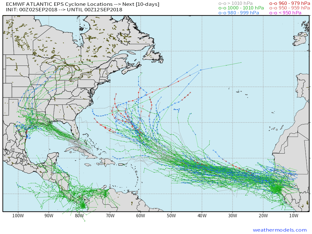 The tropical disturbance entering the GOM (Gulf of Mexico) early week will begin to find a more favorable upper level environment for further strengthening. While we always have to be cautious with any sort of tropical entity in the Gulf of Mexico this time of year, the greatest immediate concern is for locally heavy rain along the northern Gulf Coast early and middle parts of the week.
Then attention will shift to the potential of remnant tropical moisture “curling” around the periphery of the eastern ridge during the latter half of the week. While far too early to get specific, chances are there for elevated hefty rain chances for areas from the MS Valley into the Mid West as we get set to close the shortened work week and head into next weekend.
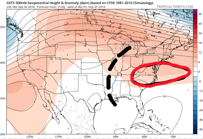
 While the axis of heaviest rainfall will have to be fine tuned, confidence is high on unsettled times returning around these parts beginning Wednesday- thanks to the combination of an approaching cold front and remnant tropical moisture.
Permanent link to this article: https://indywx.com/2018/09/02/tropics-begin-to-heat-up/
Aug 27
VIDEO: Midweek FROPA; Looking Ahead To Labor Day Weekend…
You must be logged in to view this content. Click Here to become a member of IndyWX.com for full access. Already a member of IndyWx.com All-Access? Log-in here.
Permanent link to this article: https://indywx.com/2018/08/27/video-midweek-fropa-looking-ahead-to-labor-day-weekend/
Aug 25
VIDEO: Stormy Open To Our Saturday; Looking Ahead Towards Labor Day…
You must be logged in to view this content. Click Here to become a member of IndyWX.com for full access. Already a member of IndyWx.com All-Access? Log-in here.
Permanent link to this article: https://indywx.com/2018/08/25/video-stormy-open-to-our-saturday-looking-ahead-towards-labor-day/
Aug 20
Heavy Storms For Some Tonight And Looking Ahead…
A warm front is draped across the state this evening. At the same time, surface low pressure is spinning across north-central MO with a trailing cold front entering IL. This evening, a warm and moist airmass continues to advect into central Indiana.
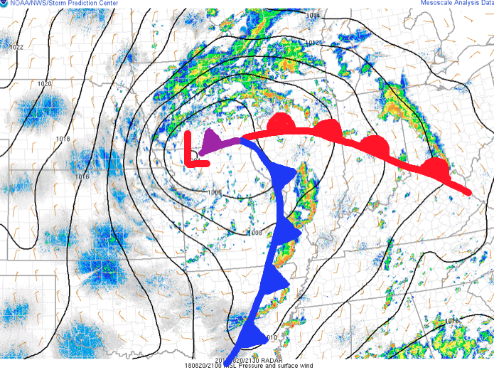 As we type this update, widely scattered thunderstorms are impacting areas from Lafayette to the northeast side of Indianapolis. A more organized complex of thunderstorms is firing to our southwest- from south-central IL to southeastern MO and into AR. This is ahead of the cold front.
Looking at forecast radar products, the majority of data brings a couple rounds of showers and thunderstorms through central parts of the state around 9p to 10p, continuing into the overnight and predawn hours.
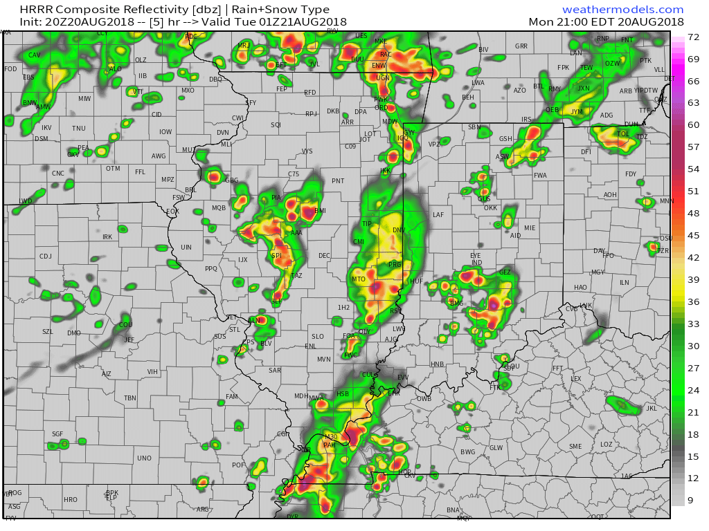
9p forecast radar

11p forecast radar

2a forecast radar
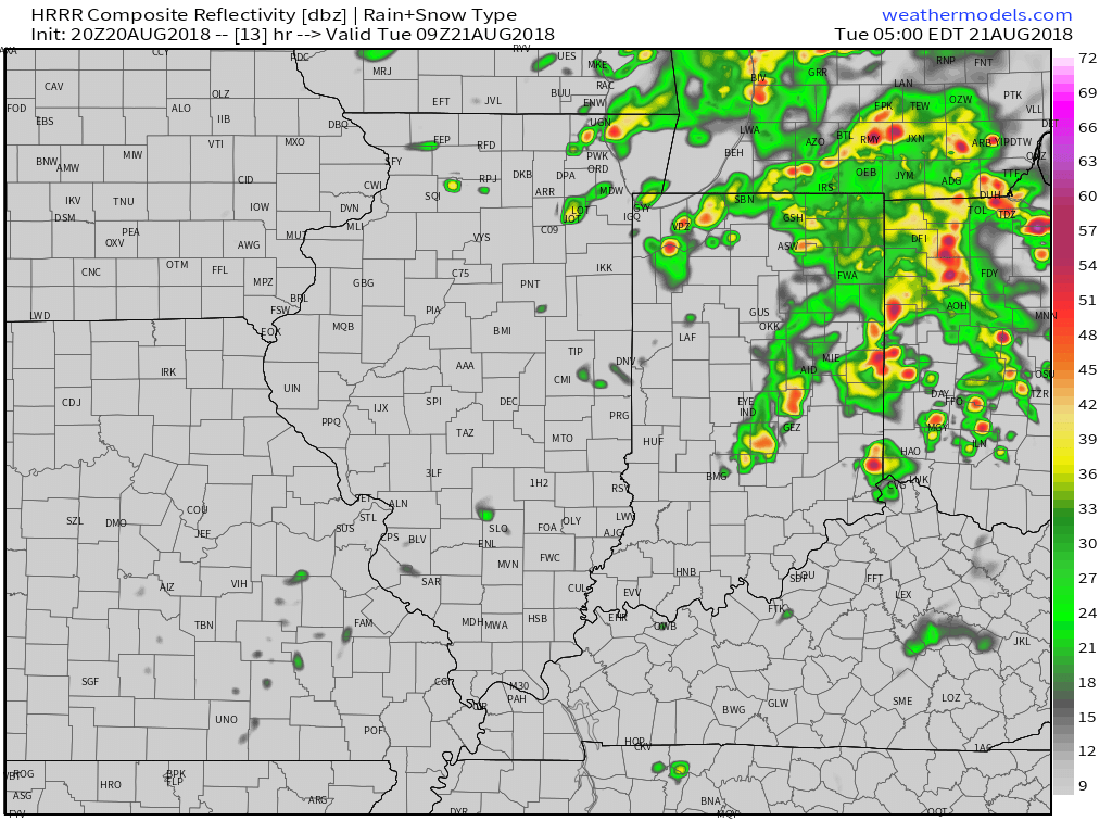
5a forecast radar
With high precipitable water values in place (approaching 2″ through tonight), locally heavy rain is likely with thunderstorms through the night. We expect widespread additional rainfall tonight of 0.50″ to 1″ with locally heavier amounts. A few embedded strong to severe storms are also possible tonight with the primary concern being damaging straight line winds and large hail, but an isolated quick spin-up tornado can’t be ruled out. We suggest ensuring your weather radio is set with the ‘alert mode’ on tonight.
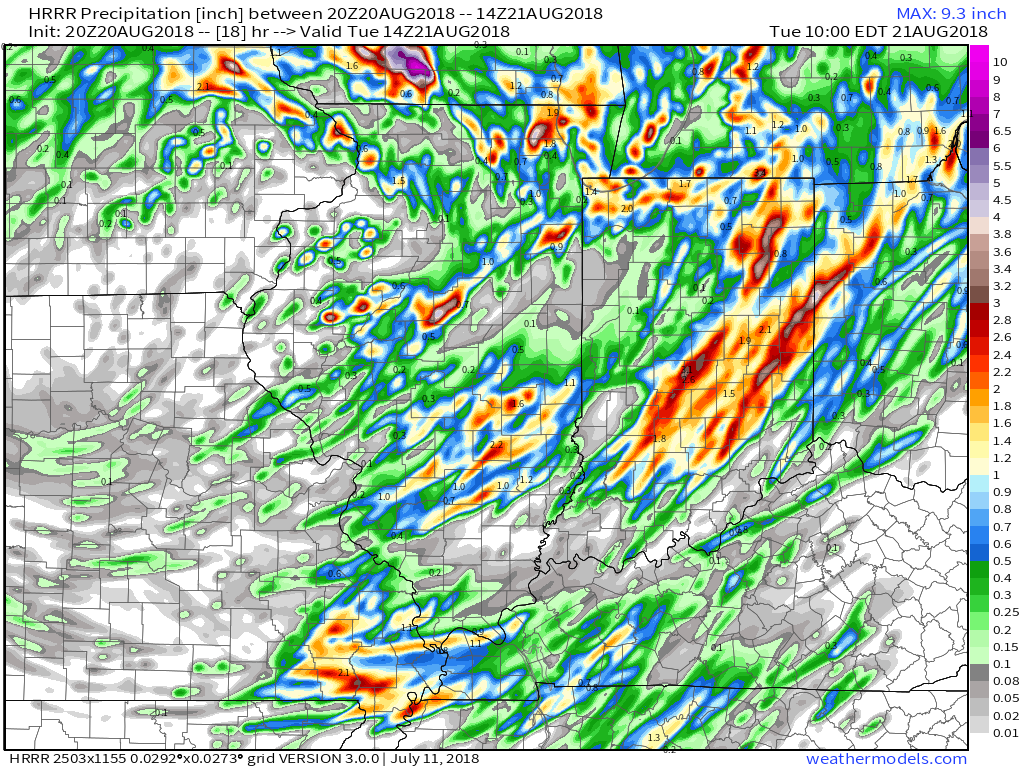
As we flip the page, a few scattered showers will remain in our forecast Tuesday PM before a much cooler and drier air mass invades Tuesday evening- continuing into Friday morning. Several central Indiana neighborhoods will dip into the 40s Thursday and Friday mornings.
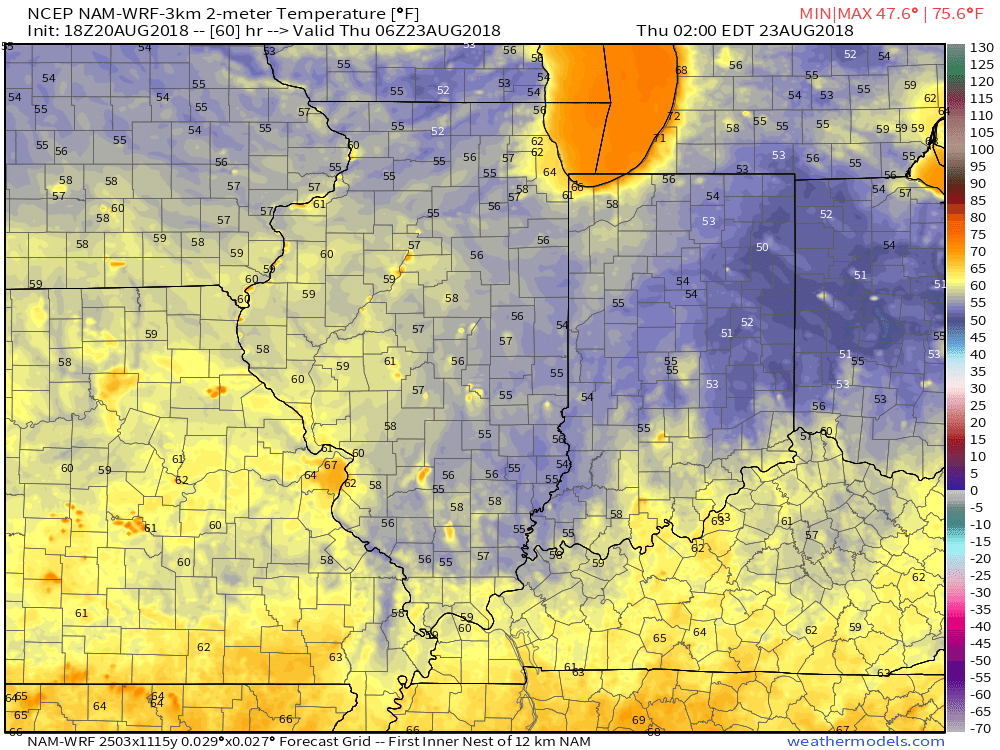
2a forecast temperatures Thursday.
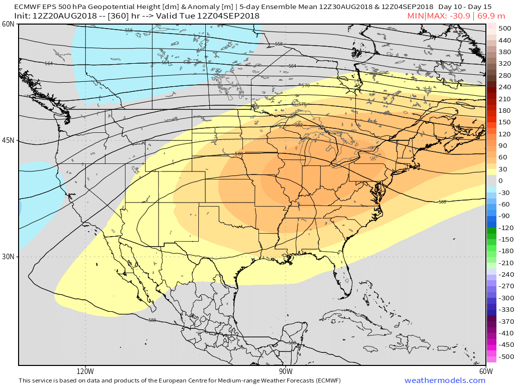
Enjoy the cooler air while you’ve got it, as a developing heat wave will engulf much of the region as we close the month and open September. Needless to say, despite the unofficial end to summer just around the corner, there’s still plenty of summer left in the tank. This is the type pattern that can produce an extended stretch of lows around 70° and highs around 90°.
Permanent link to this article: https://indywx.com/2018/08/20/heavy-storms-for-some-tonight-and-looking-ahead/
Aug 17
VIDEO: Storms Diminish Tonight; Early Week System Delivers Strong Storms & A Hint Of Fall…
You must be logged in to view this content. Click Here to become a member of IndyWX.com for full access. Already a member of IndyWx.com All-Access? Log-in here.
Permanent link to this article: https://indywx.com/2018/08/17/video-storms-diminish-tonight-early-week-system-delivers-strong-storms-a-hint-of-fall/
Aug 16
VIDEO: Bumpy Start Friday; Early Week Storm Is Followed By A “Hint” Of Fall…
You must be logged in to view this content. Click Here to become a member of IndyWX.com for full access. Already a member of IndyWx.com All-Access? Log-in here.
Permanent link to this article: https://indywx.com/2018/08/16/video-bumpy-start-friday-early-week-storm-is-followed-by-a-hint-of-fall/
