To date, February is running slightly cooler and drier than average, locally. Expect a beautiful Saturday and we officially have issued a white leg warning. 🙂 With highs…
You must be logged in to view this content. Click Here to become a member of IndyWX.com for full access. Already a member of IndyWx.com All-Access? Log-in here.
Severe threat from the Mid South to the Ohio Valley Tuesday
Impactful winter event developing late in the period
Summary: The forecast period will begin with strong ridging across the eastern half of the CONUS, while a significant trough digs across the west. That trough will lift northeast through the middle of the upcoming work week before re-amplifying over the upcoming weekend into early week 2 across the Plains and Ohio Valley region.
Sensible Impacts: A significant storm system will move off the Rockies and into the Plains Monday. The surface low will track northeast from SE CO Monday night into SW MI Tuesday night. To the north and northwest of the surface low, heavy snow and blizzard conditions will impact areas from CO, KS, NE, IA, MN, and WI. South and southeast of the surface low track, strong to severe thunderstorms will rumble through the lower MS Valley, TN Valley, and Ohio Valley Monday night into Tuesday night. All modes of severe weather will be possible, including tornadoes.
We’ll need to keep a close eye on the potential of a clipper system diving SE across the N. Plains and upper Ohio Valley over the upcoming weekend, but the bigger event appears to be a developing winter storm threat centered on the end of the period (2/8-2/10 time period). There are, obviously, a lot of details to sort through, but an impactful winter event is very possible across the Ohio Valley towards the end of the forecast period.
Temperature Anomalies: The period will open much warmer than normal, but transition cold, and eventually colder than normal by the end of the period across the forecast region.
Anomalous warmth will engulf the Ohio Valley to open the forecast period. Source: Penn State E-WallThe pattern shifts colder than normal towards the end of the period across the Plains into the southeast. Source: Penn State E-Wall
Precipitation: A stripe of heavy snows (10″-15″) will fall from CO, NE, IA, southern MN, and WI with the initial early week storm. .5″-1.5″ of rain will fall across the Southeast, TN, and OH Valley regions (locally heavier totals where strong storm train). Overall, quieter times return mid and late week for the forecast region before the next potential strong storm develops late in the period.
For private weather consulting and more detailed ag-weather updates, please e-mail bill@indywx.com.
Strong Winds And Flood Threat Remains…What an active morning across central IN! Northeast winds are already gusting around 40 MPH with periods of heavy rain this morning. Across our northern tier of counties (mainly north of a line from LAF to KOK) freezing rain and sleet is the issue this morning with temperatures below freezing.
Periods of heavy rain will continue today, and we also note the threat of embedded thunder (damaging wind risk) this evening, bracketed between the hours of 6p-8p.
Image below is courtesy of Weatherbell.com
Temperatures will remain cold and raw through most of the day before we see a late day rally briefly into the lower to middle 50s. It’ll be another day with a tight temperature gradient across the state, as northern IN will struggle to make it much above freezing, while southern IN approaches the upper 60s this evening.
Midnight highs Tuesday can be expected before temperatures crash.
We’ll then set our eyes towards a weak wave of low pressure that looks to deliver a light mixed bag of precipitation Wednesday morning. The freezing line will run through the central part of IN and a mixture of light snow and light rain can be expected. MUCH colder air flows into the state behind this system and sets the stage for a cold open to 2016.
Image below is courtesy of Weatherbell.com
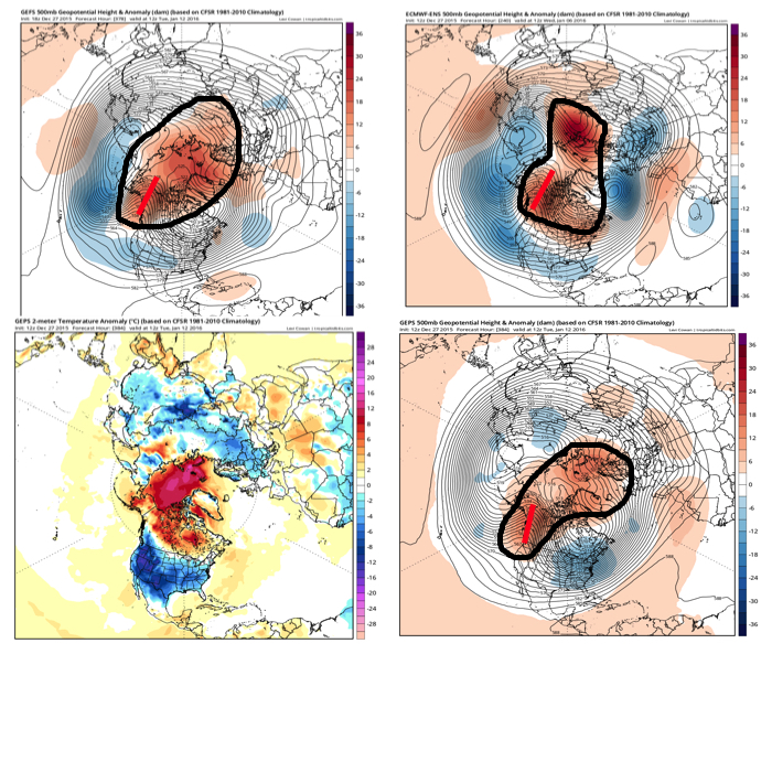
Forecast models continue to show an expected pattern shift to all-out sustained cold and wintry conditions for mid and late winter. Note the W NA ridging developing. Additionally, blocking and a negative AO develop as mid January nears. Think this is the year without a winter? Better think again, my friends.
Saturday will dawn dry across the region, but that will quickly begin to change as morning progresses into afternoon. Moisture is streaming north and a “wavy” frontal system will remain…
You must be logged in to view this content. Click Here to become a member of IndyWX.com for full access. Already a member of IndyWx.com All-Access? Log-in here.
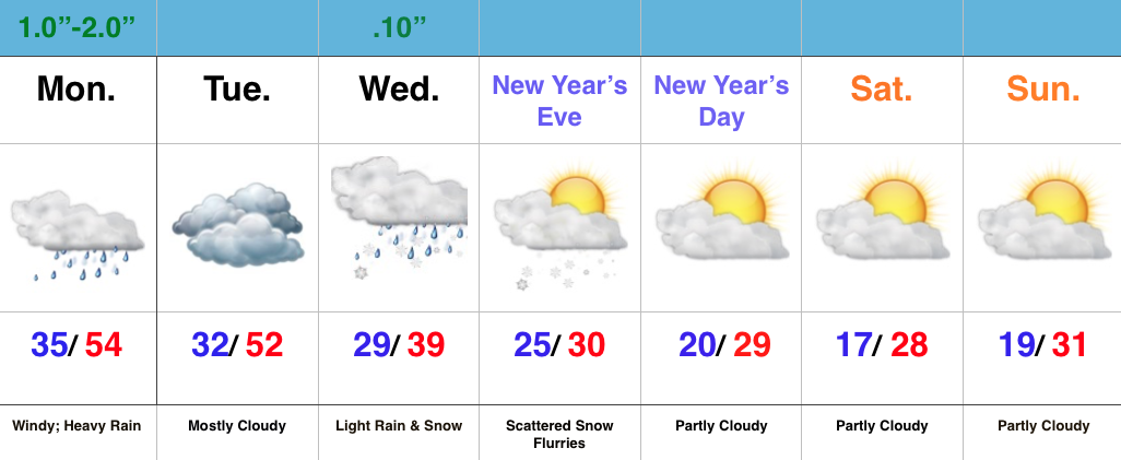
Very Wet Period Before We Turn Colder…We hope you had a blessed Christmas full of joy, peace, and laughter!
It was a beautiful Christmas across the region, complete with temperatures reaching the 50 degree mark for the first time since 1987! Many would prefer cold and snow (yours truly included), but we couldn’t ask for better weather to get out and enjoy those new gifts from Santa! The countdown to Christmas 2016 begins now. 🙂
The weather will once again turn quite active around these parts as we head into the extended Christmas weekend. Waves of heavy rain will push north Saturday and grow heavy Saturday evening. Periodically heavy rain will continue Sunday. Flooding concerns are present as event rain totals of 3″-5″ should be widespread, with locally heavier amounts.
The other big weather item to note will be the tight temperature gradient from north to south Saturday evening. Note the modeled temperature forecast Saturday night, including temperatures ranging from the lower 40s north to the upper 60s south. Heads up for central IN communities, the cold air will win out Sunday as temperatures fall through the day after an early morning high.
Image below is courtesy of Weatherbell.com
Another push of heavy rain will surge into IN Monday as low pressure tracks northeast into the Great Lakes region. A secondary area of low pressure will form along the Mid Atlantic coast Monday and provide interior portions of the NE an icy/ snowy combo to open the new work week.
Image below is courtesy of Tropicaltidbits.com
Things will (FINALLY) begin to dry out and chill down as we rumble closer to closing 2015 and welcoming 2016. Though forecast models aren’t seeing much in the way of precipitation with the surge of cold air, don’t be surprised if we deal with scattered snow showers during the Thursday-Friday period as upper energy teams up with the arctic surge.
All-in-all, it’s a step in the right direction for establishing the winter pattern that we think lies ahead, but we caution with a positive AO, things are likely to still be transient over the first 7-10 days of January. Once to mid month, we still believe a sustained shift to colder, more wintry times loom.