Rumbles of thunder woke several folks up (yours truly included) during the overnight. This was just a teaser for what lies ahead Wednesday as we continue to think a very…
You must be logged in to view this content. Click Here to become a member of IndyWX.com for full access. Already a member of IndyWx.com All-Access? Log-in here.
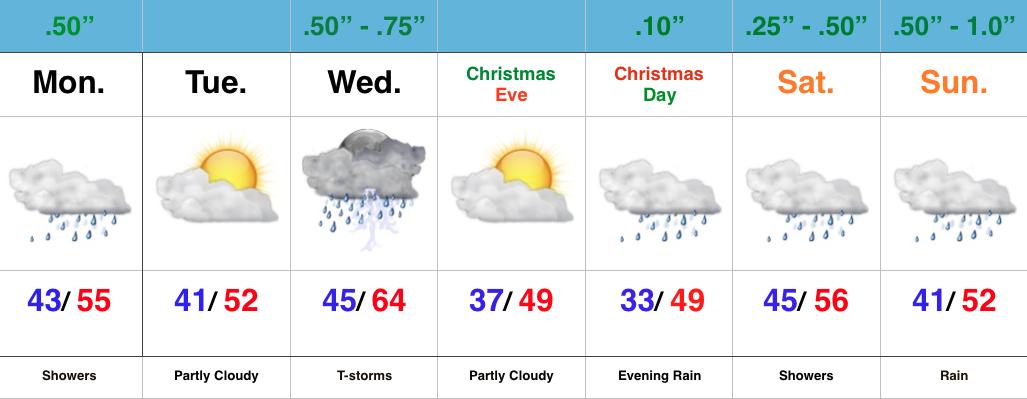
Hard to believe Christmas week is here! Unfortunately for travelers, we’re looking at a very active stretch of weather through (and beyond) the Christmas holiday.
We’re opening the short work week with rain falling across the state this morning. Steady rains will taper to showers late morning into the afternoon before drier air invades the region for a quiet Tuesday.
Storm system number 2 blows into town Wednesday and we’re a bit concerned a strong to severe storm may even be possible around these parts Wednesday. Damaging straight line winds are of greatest concern. Despite the rain, a strong southerly flow will pull abnormally warm and moist air north, helping add to the ingredients for mid week storms.
Our mid week storm will swing a cold front through here Wednesday night, setting the stage for calmer and cooler (but still above normal) weather Christmas Eve – Christmas Day. As moisture returns, we’ll forecast a mostly cloudy Christmas with showers/ drizzle possibly developing as early as Christmas evening.
Another complex storm system will be with us for the weekend, but the specifics with this system are still up in the air and will require fine tuning as we draw closer. Heavy rain appears to be the biggest threat from this distance. Get the idea that we’re looking at an incredibly busy time of things? 🙂
Some are beginning to grow tired of the seemingly unending warmth and lack of snow, particularly with an above normal stretch of weather coming that includes the Christmas holiday (though not nearly as warm as the European suggested as soon as only a few days ago).
Month-to-date, December has been a warmer than normal month for most of the country. Source: Weatherbell.com
Our winter outlook stated we thought we’d get off to a warmer than normal start, but we were also very clear in stating we thought a rather marked shift to more sustained wintry conditions loomed for mid and late winter. That period is drawing closer by the day and it’s time to “put up or shut up.” By “mid winter” we mean mid January. Yes, that means three weeks out. Without holding back any punches, we’re fully expecting a colder than average period developing by then (and with staying power), along with plenty of opportunities for wintry precipitation.
You can read our full winter outlook (published in October) here.
The reasoning for our thinking has been outlined in previous posts and in our winter outlook, but, in short, it’s built on the idea of a weakening El Nino and a mean winter upper air pattern that includes W NA ridging (positive PNA regime). Later in the season, a more sustained negative AO and NAO should establish itself that could carry the wintry regime into meteorological spring.
Current Sea Surface Temperature Anomalies
We think we begin to progress into a “step down” process to the pattern explained above through the early stages of January, and the ensemble data is beginning to support this.
GFS ensembles for early January. Source: Tropicaltidbits.com
The modeled W NA ridging is a far cry from what we’ve been dealing with over the past month.
Now we caution that the initial step down to a more sustained wintry pattern won’t occur overnight. We label it “step down” for a reason. All the while, it’s a start in shifting away from the anomalous warmth we’ve been dealing with through the month of December. Initially, cold air will only be marginal, but as things align into the mid/ late winter pattern and we expand snow cover, arctic air will grow in a more widespread fashion. Something else we’ll begin to have to keep a close eye on? A potentially active NW flow that features several clippers plenty capable of producing accumulating snow. We note central-based Ninos are notorious for the clipper parade during the mid and late winter stretch.
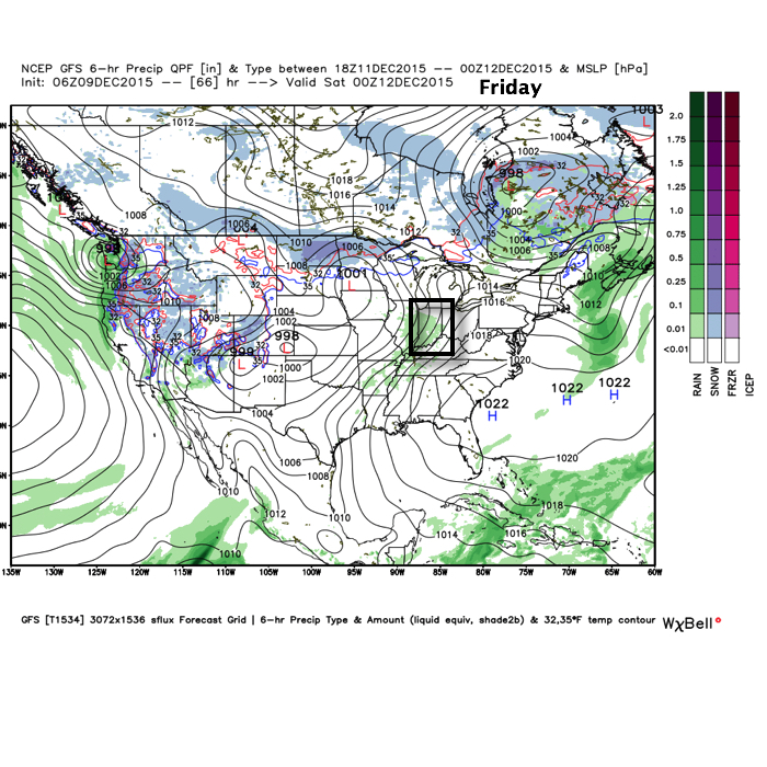
In the shorter term, a rather unsettled Christmas week looms. Modeling will continue to “sure up” the handling of a rather complex storm system after Christmas, as well. We note runs that have pumped out copious rain numbers and others that suggest wintry precipitation may fall as the cold upper low ejects northeast. We’ll continue to monitor.
In the meantime, gear up for a rather wet Monday. We think one half inch is a good bet across the area, with locally heavier totals. Our updated 7-day in the morning will be a rather busy one. Talk with you in the AM!
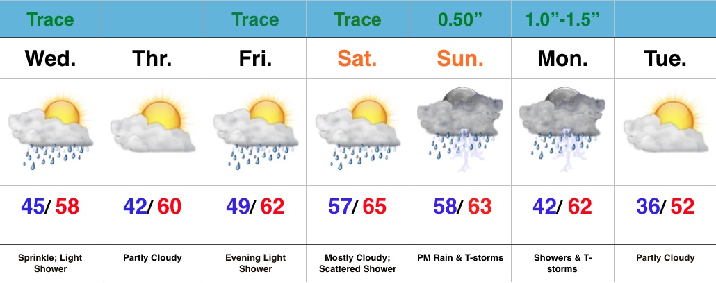
Relatively quiet weather remains in the near-term period. A fast moving disturbance will cross the state this morning and could spark a light shower or sprinkle, but we’ll get back to increasingly sunny conditions this afternoon and evening.
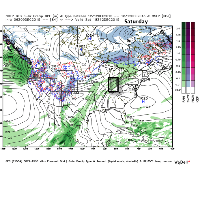
Moisture will begin to return as we close the week and head into the weekend, but it’s really not until the second half of the weekend that we begin looking at more widespread rain.
As a SW flow begins to transport Gulf of Mexico (GoM) moisture north, a light passing shower is possible Friday evening and Saturday.
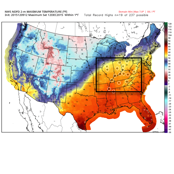
Despite the increase in cloudiness and threat of a passing shower, it won’t keep us away from flirting with records Saturday, and note the widespread portion of the Tennessee and Ohio Valley that will also be in jeopardy of setting new records.
Source: Weatherbell.com
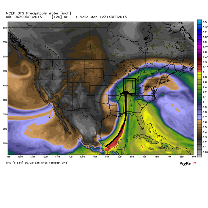
Much better rain and storm chances ramp up Sunday afternoon into Monday.
PWATs (precipitable water values) increase dramatically during the aforementioned time period and could help fuel locally heavy rains during that time period, particularly with embedded thunderstorms.
Cooler air will arrive early next week, but remain significantly above normal. We’ll discuss the longer range a bit later…
The near term period is about as quiet as you’ll get it this time of year so that gives us an opportunity to search for the next “trouble maker.” Out…
You must be logged in to view this content. Click Here to become a member of IndyWX.com for full access. Already a member of IndyWx.com All-Access? Log-in here.