
You must be logged in to view this content. Click Here to become a member of IndyWX.com for full access. Already a member of IndyWx.com All-Access? Log-in here.
Category: Hail
Permanent link to this article: https://indywx.com/video-heavy-rain-and-storms-arrive-overnight/
Jul 20
Active Severe Weather Day…
We continue to closely monitor the potential of severe weather this afternoon and evening across central and eastern portions of the state. The latest outlook from the Storm Prediction Center includes an ‘Enhanced’ risk for the majority of the state and has upgraded southeastern portions of the state into a rare ‘Moderate’ risk.
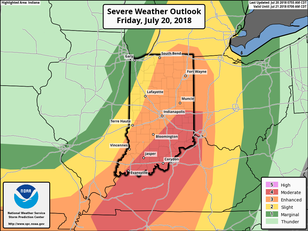 Part of the reason behind today’s severe weather has to do with an overall pattern shift. An intense short wave trough (especially for this time of year) will dig into the Great Lakes and Ohio Valley. At the surface, an area of low pressure will track from southern WI (this morning) before “cutting off” over the Ohio Valley this weekend. Additionally, a couple of frontal boundaries will swing through the state- the most potent being the boundary that surges east this afternoon and evening. The combination of ingredients spell trouble across at least a portion of the region- especially from Indianapolis and points south and east this afternoon and evening.
High resolution forecast radar products are likely struggling with handling the specifics today, but we think one or two lines of storms will track southeast across the state this afternoon and evening. The risk of severe weather will diminish from 7p to 8p from northwest to southeast across the state. Greatest concerns from a severe perspective include the potential of large, damaging hail and straight line winds. Additionally, a tornado or two can’t be ruled out. It’ll be important to remain weather-aware this afternoon and evening. Have a means of getting the latest information with respect to watches and warnings that may be issued later today from the National Weather Service.
As we look ahead, though the severe threat will end, unsettled times will remain this weekend. In fact, a couple of the stronger showers Saturday afternoon could contain hail (below severe levels), due to the cold air aloft associated with the upper low. Greatest coverage of showers this weekend will come during the afternoon and evening hours both Saturday and Sunday.
Permanent link to this article: https://indywx.com/active-severe-weather-day/
Jun 22
VIDEO: Stormy Close To The Week; July Chatter…
You must be logged in to view this content. Click Here to become a member of IndyWX.com for full access. Already a member of IndyWx.com All-Access? Log-in here.
Permanent link to this article: https://indywx.com/video-stormy-close-to-the-week-july-chatter/
May 31
Steamy Thursday Ends Stormy…
The Storm Prediction Center has placed southwestern Indiana under a Slight risk of severe weather, with extreme southern Indiana now included in an Enhanced risk.
 Upper level energy will push east this afternoon and combine with an unstable air mass, along with unseasonably hot and humid air (highs today will reach the lower 90s across the southern half of the state with dew points around 70°), resulting in explosive thunderstorm development this evening. Storms will rumble east during the nighttime hours before exiting off to the east and diminishing during the early morning hours.
 We target the time frame of 6p to midnight for greatest storm coverage and the possibility of severe weather. While the greatest threat of severe is just south of the city, itself, I think all of central IN is in play for the possibility of strong to severe thunderstorms tonight. In addition to locally heavy rain, stronger storms could pose a damaging straight line wind threat along with large hail.
A couple of storms may still fire Friday afternoon in the warm and humid air mass, but a boundary will pass Friday evening, allowing less humid air to arrive Saturday. On that note, even cooler and less humid air awaits early next week.
Permanent link to this article: https://indywx.com/steamy-thursday-ends-stormy/
May 09
Timing Out Storm Chances Tonight…
We continue to monitor things closely for the potential of strong to severe thunderstorms this evening into tonight. As of this morning, we still believe greatest threats of severe weather…
You must be logged in to view this content. Click Here to become a member of IndyWX.com for full access. Already a member of IndyWx.com All-Access? Log-in here.
Permanent link to this article: https://indywx.com/timing-out-storm-chances-tonight/