Category: Freezing Rain

Client Brief: Multiple Rounds Of Wintry Precipitation Expected Tuesday Night-Thursday Night…

Type: Impactful Wintry Weather

A wintry mix will begin to impact parts of central IN as early as Tuesday evening.

What: Potential of accumulating snow, sleet, and freezing rain

When: Multiple rounds:

I. Tuesday evening through Wednesday morning

II. Wednesday evening through Thursday evening

Temperatures: Upper 20s to lower 30s

Wind: Northeast 20 to 30 MPH and gusty Tuesday night, shifting to the north, northwest 5 to 15 MPH Wednesday night into Thursday.

Blowing/ Drifting: Non-existent

Pavement Impacts: Salting/ plowing also will likely be required in the “snow zone.”

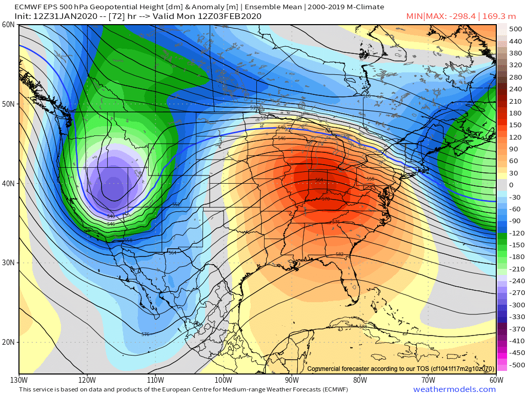
A complex weather pattern will result in a multitude of precipitation types across the state in the Tuesday night through Thursday night time period. Here’s our early thinking where we think the various types of precipitation setup shop:

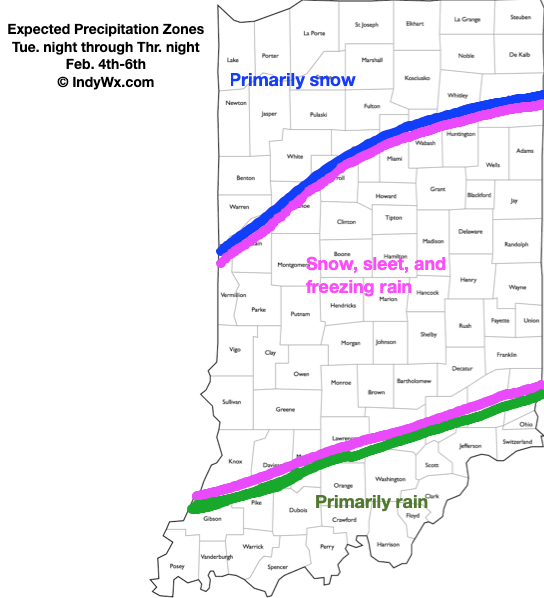
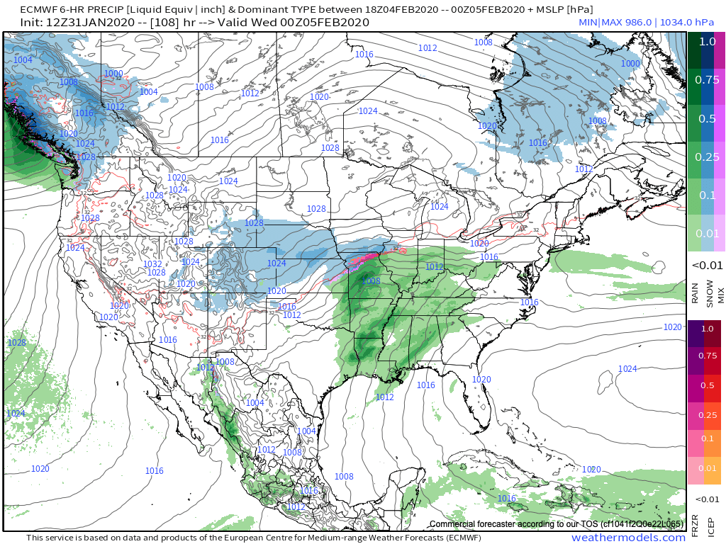
As we time things out, rain is expected to overspread most of the state Tuesday morning. Heaviest and most concentrated rainfall should occur along and south of the I-70 corridor. A downright balmy start to the day will trend significantly colder (especially around and after lunchtime). As cold air continues to ooze south, renewed precipitation is expected to break out Tuesday evening into Wednesday morning, courtesy of a wave moving along the cold front. With colder air in place, this precipitation is expected to primarily fall in the form of sleet and freezing rain through the “heart” of central Indiana with snow across northern parts of the state. With temperatures falling below freezing Tuesday evening, slick spots on area roadways are anticipated to develop- even despite the recent warm weather of the past couple of days.

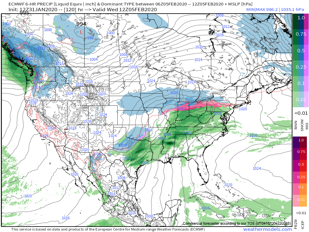
Most of the daytime should feature a relative “lull” in the precipitation with nearly steady temperatures across central and northern Indiana (around or just below freezing). The briefly quiet times will give way to another round of more widespread and heavier precipitation Wednesday evening, continuing into the day Thursday as a stronger wave of low pressure moves northeast from northern MS, along the Ohio River, and into eastern Ohio. Like what we’ll experience tomorrow evening, the precipitation forms will vary significantly based on your locale. We think another round of sleet (perhaps some freezing rain across south-central Indiana) will dominate across central Indiana, with primarily snow across northern Indiana. Within the highlighted “snow zone,” amounts of 3″ to 6″ certainly seem possible by the time all is said and done Thursday evening.

Confidence: Medium

Next Update: Tuesday morning

Permanent link to this article: https://indywx.com/client-brief-multiple-rounds-of-wintry-precipitation-expected-tuesday-night-thursday-night/

VIDEO: Pleasant Open To The Week Takes On A More Wintry 2nd Half…

You must be logged in to view this content. Click Here to become a member of IndyWX.com for full access.  Already a member of IndyWx.com All-Access?  Log-in here.

Permanent link to this article: https://indywx.com/video-pleasant-open-to-the-week-takes-on-a-more-wintry-2nd-half/

VIDEO: Multiple Complex Storms To Deal With In The Week Ahead…

You must be logged in to view this content. Click Here to become a member of IndyWX.com for full access.  Already a member of IndyWx.com All-Access?  Log-in here.

Permanent link to this article: https://indywx.com/video-multiple-complex-storms-to-deal-with-in-the-week-ahead/

Time To Beat The Drum A Little Louder On Next Week?

After a surge of warmth engulfs the region during the early part of the week, a cold front will sag south into the central Ohio Valley Tuesday night into Wednesday.

An upper level ridge will provide a brief taste of spring to open the week.

This front will result in an expanding shield of rain Monday night into Tuesday across all of central Indiana.

Rain will increase across the area Monday evening.

As we progress through Tuesday evening, the frontal boundary will likely sag south, allowing colder air to filter in (at least at the lowest levels of the atmosphere) across north-central parts of the Ohio Valley. As another slug of moisture moves northeast along the frontal boundary, precipitation is expected to once again become widespread Tuesday night into Wednesday. With the colder air oozing in, a mixture of sleet and freezing rain is a possibility across northern IL, IN, and OH. The precise placement of the front will determine whether or not more of central Indiana can get in on the “excitement” of this icy mixture during the aforementioned time period.

It’ll be wise to pay attention to forecast details during the weekend for the Tuesday and Wednesday time period- especially if you have travel plans north.

As this takes place, the upper ridge will get “beaten back” into the 2nd half of the work week. It’s important to note, however, that there will likely still be enough resistance from the upper level ridge that the cold front will get hung up along or just east of the spine of the Appalachians in the Thursday-Friday time frame.

As this transpires, yet another wave of energy will move up along the pressing boundary. Accordingly, precipitation should once again blossom in response of this wave of low pressure moving northeast. While the European (shown below) wants to keep things east of the immediate region, it’s wise not to write this system off from this distance. Not only does other data show the threat locally, but it’s all too often where storm systems “correct” further west as time draws closer to said event…

While this week has been relatively boring in the weather department, things will change in significant fashion next week. Whether or not those changes can deliver “wintry goods” is TBD…

Stay tuned.

Permanent link to this article: https://indywx.com/time-to-beat-the-drum-a-little-louder-on-next-week/

VIDEO: Short-Term Update On Tonight’s Sleet And Freezing Rain…

You must be logged in to view this content. Click Here to become a member of IndyWX.com for full access.  Already a member of IndyWx.com All-Access?  Log-in here.

Permanent link to this article: https://indywx.com/video-short-term-update-on-tonights-sleet-and-freezing-rain/