Category: Freezing Rain

Weekend Snow Storm Brewing…

As the weekend approaches, we’re getting set for another winter storm across the Hoosier state.

After two brutally cold days in Friday and Saturday, our eyes will shift to a potentially hefty snow storm late Saturday night into Monday morning.  This will be a bit of a different set up from what previous storms this winter have provided.  A relatively “flat” wave of low pressure will move out of the southern Plains Saturday and slowly through the southern Ohio Valley Sunday.  Widespread precipitation will overspread the region late Saturday night and continue through most of Sunday, and even into early Monday in some cases.  This will be a relatively long duration event and the impacts will likely be high from a travel perspective Sunday into Monday morning.

1


2


Concerning precipitation type, we still believe the combination of a bitterly cold pattern and a widespread snow pack will play a significant role in this event.  It’s always difficult to get more than a wintry form of precipitation when moisture “attacks” true arctic air.  As of now we see this storm being an all snow event for places around and north of the I-70 corridor.  South of there, it’s possible mixing gets involved- including potentially some freezing rain downstate.

Due to the fact that this should be a rather prolonged event, significant snowfall will be possible where precipitation stays (or remains predominantly) snow.

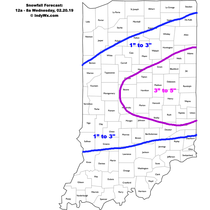
Here’s our best guess where the heaviest snowfall potential lies currently.  Remember, snow totals won’t necessarily follow the clean lines below.  This should be used as guidance at this point for where we’re focusing our attention for the potential of heaviest snowfall totals.  Being that this is still an event late Saturday night through Monday morning, obviously things are subject to change.  We’ll have our first specific accumulation map posted Friday evening.  Stay tuned.

29151stcall

Permanent link to this article: https://indywx.com/2015/02/26/weekend-snow-storm-brewing-2/

Wednesday Evening Video Update: Loaded Pattern.

You must be logged in to view this content. Click Here to become a member of IndyWX.com for full access.  Already a member of IndyWx.com All-Access?  Log-in here.

Permanent link to this article: https://indywx.com/2015/02/25/wednesday-evening-video-update-loaded-pattern/

Busy AND Wintry Forecast…

Screen Shot 2015-02-25 at 7.27.09 AMBrief Break From The Severe Cold, But Not For Long…Today will be the “pick of the week” as milder air and some sunshine lead to a decent Wednesday. (It’s funny we say “milder” with highs that barely rise above our average low, but we’ll take what we can get).

A clipper system will impact the region tonight through Thursday and spread light snow across the area.  This won’t be a big deal, but accumulations around 1″ will be possible (perhaps an isolated 2″ report here or there).  The bigger deal?  Fresh bitterly cold arctic air pushing in here to wrap up the work week and head into the weekend.  Record-smashing cold and dangerous wind chills will be with us.

The next storm system will spread snow and a wintry mix through central Indiana Saturday night into Monday morning.  As we mentioned last night, this is a fluid situation and it’s still far too early for specifics.  That said, central Indiana is very much in play for another accumulating wintry event this weekend.

A final piece of energy will deliver more precipitation early next week.  As of now we forecast a wintry mix of snow and sleet to transition to rain as milder air pushes in from the southwest Tuesday.  Again- much can still change.

Upcoming 7-Day Precipitation Forecast:

  • 7-Day Rainfall Forecast:  0.50″ – 0.75″
  • 7-Day Snowfall Forecast: 3″ – 6″

Permanent link to this article: https://indywx.com/2015/02/25/busy-and-wintry-forecast/

Winter Storm Video Brief

You must be logged in to view this content. Click Here to become a member of IndyWX.com for full access.  Already a member of IndyWx.com All-Access?  Log-in here.

Permanent link to this article: https://indywx.com/2015/02/20/winter-storm-video-brief/

Winter Storm Tonight-Saturday

Good morning and happy Friday, friends!  Boy, Old Man Winter is really beginning to turn some minds around from thinking this was an easy winter to one that’s quite impressive, especially from a cold standpoint.  By the way, there’s MUCH more from where this came from!  Essentially we remain on “lock down” for more brutally cold and wintry conditions for the upcoming 7-10 day period.  More on that later.

Here’s a look at our initial snowfall forecast map for tonight and Saturday:

2201522115SnowMapForecast radar shows heavy wet snow encompassing central Indiana Saturday morning:

hires_ref_indy_29Bullet point highlights you need to know:

  • Snow will overspread central Indiana from the southwest between 10p-1a
  • Snow will become heavy at times between 3a-7a
  • Sleet and freezing rain will accumulate significantly downstate
  • Most of the snow will be east of the area by 3p Saturday
  • You’ll want to plow and clean snow up Saturday night as cold air quickly returns Sunday
  • Arctic outbreak next week likely will feature record cold, and colder than this week has been
  • No let-up in sight from this unrelenting winter pattern

Permanent link to this article: https://indywx.com/2015/02/20/winter-storm-tonight-saturday/

Latest Thinking On Friday Night-Saturday Winter Storm…

Here’s our latest thinking in regards to Friday night and Saturday.

2201522115Snowfall1stCallHighlights:

  • Light snow will likely overspread central Indiana Friday night with precipitation intensity increasing late night into early Saturday.
  • Periods of light to moderate precipitation (location dependent between snow, ice, and rain) will impact the area Saturday, especially through early afternoon. Several inches of snow will be possible in the “mainly snow zone,” and a first call accumulation forecast will be posted Friday morning.
  • You’ll want to shovel and plow any snow and ice Saturday night as temperatures fall Sunday.
  • We’ll welcome in the arctic express yet again next week, including more sub-zero temperatures ahead. In fact, next week may feature colder conditions than our current arctic outbreak, especially if we put a snowpack down across central Indiana.

Permanent link to this article: https://indywx.com/2015/02/19/latest-thinking-on-friday-night-saturday-winter-storm/

Arctic Express Rolling Down The Tracks…

Screen Shot 2015-02-19 at 7.24.59 AMHeavy Cold Weather Gear Needed…It’s a frigid morning across central Indiana with all reporting sites well below zero.  Despite the sunshine today, we’ll only “warm” into the middle single digits- smashing the former record cold maximum of 12 degrees.  Amazing stuff!  Wind chills will remain below zero and downright dangerous.

Eyes shift to a wintry weather maker this weekend and overnight computer guidance has begun to catch onto a much more realistic suppressed, colder solution, as opposed to the warmer and more aggressive storm into the Ohio Valley.  We still have time to watch for additional changes, but for now we think light snow overspreads central Indiana Friday evening, before a bit heavier precipitation moves in late Friday night and Saturday morning.  The “2nd round” of precipitation will likely consist of most of the ice/snow accumulation, including mostly snow across north-central Indiana, a messy mix of sleet and freezing rain across the heart of central Indiana, and a cold rain downstate.  Caution though that this is still preliminary thinking and certainly subject to change.  An early guesstimate on central Indiana snowfall potential with this system would be for a light to borderline moderate event- 2″ to 4″ type deal.

The Arctic Express quickly gains momentum yet again Sunday night and will lead to another frigid week next week.   This pattern is getting to be unbelievable from both the sustained cold, but the extreme nature of the cold, as well.  Put this into perspective, only three days of the above forecast period feature high temperatures close to, or slightly warmer, than our average low.

Upcoming 7-Day Precipitation Forecast:

  • 7-Day Snowfall Forecast: 2″ – 4″
  • 7-Day Rainfall Forecast: 0.10″

Permanent link to this article: https://indywx.com/2015/02/19/arctic-express-rolling-down-the-tracks/

Dangerous Cold; Weekend Talk…

You must be logged in to view this content. Click Here to become a member of IndyWX.com for full access.  Already a member of IndyWx.com All-Access?  Log-in here.

Permanent link to this article: https://indywx.com/2015/02/18/dangerous-cold-weekend-talk/

Tuesday Evening Video: More Arctic Cold & Snow Ahead…

You must be logged in to view this content. Click Here to become a member of IndyWX.com for full access.  Already a member of IndyWx.com All-Access?  Log-in here.

Permanent link to this article: https://indywx.com/2015/02/17/tuesday-evening-video-more-arctic-cold-snow-ahead/

Record Cold Air Ready To Blow In…

Screen Shot 2015-02-17 at 7.06.29 AMHeavy Duty Cold Weather Gear Needed…If you didn’t think it was cold enough, Mother Nature will try and do better by the middle of the week as downright bitter, and dangerously, cold air blows into town.  Scattered snow showers will accompany the arctic blast as a couple of upper level disturbances rotate across the state between today and Wednesday.  Wind chills of 20 to 25 below zero can be expected Wednesday night into Thursday morning.  Additionally, we’ll run the chance of breaking our coldest high temperature on record for Feb. 19th- Thursday (currently 12 degrees).

After a bitter, but dry couple of days to close the work week, we eye the upcoming weekend for our next storm system.  For now we’ll forecast increasing cloudiness late Friday and a wintry mix overspreading the region Saturday.  We’ll become more detailed in regards to precipitation type, amounts, and timing over the next day, or two.  Fresh arctic air will flow in here to close the weekend.

Upcoming 7-Day Precipitation Forecast:

  • 7-Day Snowfall Forecast: 1″ – 2″
  • 7-Day Rainfall Forecast: Trace

Permanent link to this article: https://indywx.com/2015/02/17/record-cold-air-ready-to-blow-in/

IndyWx.com