Category: Forecast

Period Of Snow Moving In…

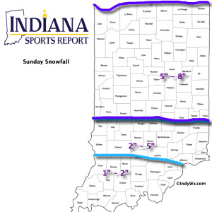
As mentioned below, bust potential was/ is high with today’s forecast.  The further north trends in the NAM and GFS will ultimately trump the normally reliable Canadian and European solutions.  As such, slushy snowfall accumulations will be light (1″-2″) for the city, itself, increasing to between 2″-5″ for northern Indianapolis suburbs (Zionsville, Carmel, Westfield, Noblesville, etc.).  Double digit totals will fall across the northern third of the state.

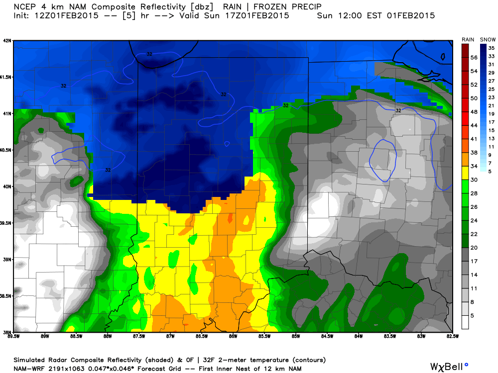
For the most part, snowfall accumulations will come from this area of precipitation moving through the region.

Screen Shot 2015-02-01 at 9.30.06 AM


Heavy wet snow will likely fall for a period of time, especially from northern portions of Indianapolis and points north late morning into the early afternoon.

hires_ref_indy_6


Temperatures will then likely creep up a few degrees through the mid afternoon hours before falling this evening.  Snow will mix with, or change to, snow across central regions this afternoon with the northward track of the low.  Note the stark temperature contrast across the region this evening.

hrrr_t2m_indy_16


The week will get off to a cold start as highs Monday only top out in the lower 20s.  Enjoy your Super Bowl Sunday and keep the reports coming!

Permanent link to this article: https://indywx.com/2015/02/01/period-of-snow-moving-in/

Crippling Snow Storm For Some; Just Wet For Others.

An incredibly difficult and challenging forecast is in store for central Indiana over the course of the next 24-36 hours.  I want to get out front with this right from the get go: bust potential is high with this type set-up, as a jog 10-20 miles north or south of the surface low will mean the difference between half a foot of snow and plain cold rain.  As it stands now, and after careful consideration of every piece of data available, here’s our updated snowfall map:

SnowfallMap2115V2


I still am not sure any one piece of data is handling the interaction between the arctic high to the north and the developing low to our southwest “perfectly.”  As such, additional fine tuning will have to take place tonight.  That arctic high is powerful at nearly 1045mb.  From a meteorological standpoint, it’ll be a fascinating battle watching the fight play out.

As you can see, we’re going to be looking at a very tight thermal gradient and it, unfortunately, appears to set itself up directly over the I-70 corridor.  Precipitation type and amounts are the biggest challenge within the I-70 corridor.  Further north, confidence increases rather significantly for a crippling snow storm.  For central Indiana, this will be a very wet and heavy snow event before ending as a drier, powdery snow on the back end.  As winds increase Sunday afternoon/ evening, the heavy “paste” like snow won’t blow around as easily as it would if it was drier.  Further north the snow consistency will be drier and blowing and drifting will be severe (in the 8″-12″+ zone).

In the shorter-term, rain and a wintry mix will arrive into the region as early as early as 6-7 o’clock.

Stay tuned.  Another post will hit here late tonight (midnight-ish).  In the meantime, we’ll keep our thoughts coming at @indywx through the afternoon.

Permanent link to this article: https://indywx.com/2015/01/31/crippling-snow-storm-for-some-just-wet-for-others/

Weekend Snow Storm…

Screen Shot 2015-01-30 at 7.10.35 AMWeekend Snow Storm On Deck…Scattered snow flurries and snow showers will come to an end this morning with increasing sunshine following.  Despite seeing a little vitamin D this afternoon, it won’t do anything to help us in the temperature department.  In fact, we already experienced our high around midnight.  Temperatures this afternoon will remain in the middle to upper 20s with a gusty wind.

Most of Saturday will be quiet (calm before the storm) with dry conditions and afternoon highs around 40.  Clouds will lower and thicken as we go through the afternoon and evening and snow will develop (rain or a wintry mix down state initially) across central Indiana during the overnight.  Snow will increase in intensity Sunday morning and grow heavy at times during the day as low pressure tracks along the Ohio River (a classic track for central Indiana snow storms).  See our initial accumulation map below, which is still subject to change.  We’ll introduce a gusty east and northeast wind into the mix Sunday evening and night and this will lead to blowing and drifting snow Sunday night.  Stay tuned.

The big story next week will be the cold, but we’re also watching two potential snow makers, as well.  More on that after we deal with Sunday’s snow storm.

Upcoming 7-Day Precipitation Forecast:

  • 7-Day Snowfall Forecast: 5″ – 10″
  • 7-Day Rainfall Forecast: Trace

2115SnowfallMap

Permanent link to this article: https://indywx.com/2015/01/30/weekend-snow-storm/

Now This Is More Like It…

Screen Shot 2015-01-28 at 7.30.19 AMMaking Up For Lost Time…Many snow lovers out there have been disappointed by the lack of the white stuff winter to date.  The cool thing is that the next 7-10 days (most likely longer) will offer up multiple opportunities to serve up accumulating snow.

First things first and that’s today- look for bright sunshine and a frosty start.  Temperatures will “warm” to just under seasonal levels this afternoon.  A fast moving storm system will scoot through here late tonight and Thursday morning with light rain, possibly transitioning to light snow showers before precipitation ends Tuesday (not a big deal).  Far eastern areas may experience a brief period of light freezing rain or light sleet during the onset of precipitation, but things should switch over to light rain rather rapidly even for you.  We’ll turn dry and cold to wrap up the work week.

All eyes are on the weekend as a storm system moves towards the region.  We have a ways to go and we’ll have to fine tune the details over the next few days, but this has potential to be the most widespread significant wintry event of the season.  Stay tuned.  MUCH colder air will punch in here early next week and may set the stage for more wintry “mischief” by the middle of next week.

ISRlogo2-280x121IU at Purdue: 9p tonight

Good news is that for those driving to West Lafayette tonight, you should be dealing with dry conditions.  Precipitation chances will begin to go up as we near 11p, or after, for western portions of the state.

Upcoming 7-Day Precipitation Forecast:

  • 7-Day Rainfall Forecast: 0.25″
  • 7-Day Snowfall Forecast: 3″ – 6″

Permanent link to this article: https://indywx.com/2015/01/28/now-this-is-more-like-it-2/

Light Snow Impacts Some This Evening…

Screen Shot 2015-01-26 at 7.44.39 AMSlick Travel This Morning; More Light Snow This Evening…Rain changed to snow in and around Indianapolis between 5-6 Sunday evening.  The changeover occurred earlier just north and northeast of the city where anywhere from a quarter inch of snow fell to as much as 3 inches in and around the Muncie area.  The big problem last night and this morning is the combination of moisture freezing on the roadways, light snow, and strong and gusty winds.  Area roadways have been reported slick with numerous accidents.  Take it slow this morning.

Most of today will be quiet and dry, but light snow will build into the state later this evening into tonight.  We target areas along and west of I-65 for the greatest opportunity of accumulating a dusting to half an inch of snow tonight.  Sunshine returns Tuesday before a mid week system brings light rain Wednesday night into Thursday.  Light rain will diminish as light snow Thursday.

Colder air will be with us as we wrap up the work week before our next storm system impacts the Hoosier state over Super Bowl weekend.  We forecast increasing clouds Saturday with snow developing Saturday night into Sunday.

Upcoming Precipitation Forecast:

  • 7-Day Rainfall Forecast: 0.10″ – 0.25″
  • 7-Day Snowfall Forecast: 2″ – 4″

Permanent link to this article: https://indywx.com/2015/01/26/light-snow-impacts-some-this-evening/

Tough Forecast Today…

Screen Shot 2015-01-25 at 9.04.28 AMHigh Bust Potential Today…Clippers are always tough to forecast, but particularly so today.  This is a vigorous system and while temperatures will only be marginally cold, the concern here is that precipitation rates may help cool the entire column of air a bit quicker this afternoon than modeling currently suggests.  If (big if) that’s the case, then snowfall amounts below would have to be increased.  As it is now, we feel about as confident as we can be right now that the “slimmed” down numbers below will suffice.  As has been the case with a couple of other events this winter, it’ll be a nowcast scenario this afternoon.  Winds will also become quite gusty out of the east and northeast this afternoon into tonight.

Colder, drier air builds in late tonight and Monday before a weak weather system scoots through and delivers light snow showers Tuesday.  A wintry mix is possible Thursday and then we’ll eye late next weekend for the next snow opportunity.

Upcoming 7-Day Precipitation Forecast:

  • 7-Day Snowfall Forecast: 2″ – 4″
  • 7-Day Rainfall Forecast: 0.50″

12515SnowfallMapV2

Permanent link to this article: https://indywx.com/2015/01/25/tough-forecast-today/

So Long Boring Weather…

Screen Shot 2015-01-24 at 8.49.04 AMBusy Times In The Forecast Office…Let’s get to the easy part of this forecast package and that’s today.  Look for lots of sunshine along with seasonably mild temperatures after a cold and frosty start.

Things get fun tomorrow as a clipper low dives southeast and tracks in a favorable position for accumulating snow- especially from the city and points north (snowfall forecast below).  A mixture of rain and snow will overspread central Indiana Sunday morning and transition to all snow through the late morning into the early afternoon.  This will be a heavy, wet snow (perfect for snowball fights or making a snowman).  The other aspect to this storm system will be an increasing east and northeast wind Sunday evening into Monday morning.  Snow will diminish Sunday night, but the “damage” will likely be done by that point, leaving a mark on your Monday morning commute.

Another (weaker) weather maker may deliver scattered snow showers Tuesday.

Briefly milder air will move in here Thursday with a mixture of rain, snow, and sleet (depending on where you’re viewing us through the state), but the bigger story will be MUCH colder air set to pour into the region to close January and open February.  Some forecast models suggest a winter storm will precede the bitterly cold air around Super Bowl Sunday…. Stay tuned.

Upcoming 7-Day Precipitation Forecast:

  • 7-Day Snowfall Forecast: 2″ – 5″
  • 7-Day Rainfall Forecast: 0.10″ – 0.25″

12515SnowfallMap

Permanent link to this article: https://indywx.com/2015/01/24/so-long-boring-weather/

Colder, But Nothing Drastic…

Screen Shot 2015-01-21 at 6.28.17 PM

Colder, But Nothing Too Out Of The Ordinary…A colder theme will be with us as we put a wrap on the work week.  That said, temperatures will actually be much closer to where they should be for this time of the year.  A quiet weather pattern will continue until we watch a clipper system for the second half of the weekend.  As of now, the accumulating snow looks to stay north of our immediate region, but we’ll keep a close eye on it.  Officially, we’ll call for increasingly cloudy skies Saturday night into Sunday morning with scattered rain showers Sunday afternoon changing to snow showers Sunday night before ending. If traveling north, prepare for several inches of snow across northern portions of the state into the Great Lakes region.  Stay tuned as this system is still a few days off and changes can take place moving forward.  Colder air follows for early next week.

Upcoming 7-Day Precipitation Outlook:

  • 7-Day Rainfall Forecast: 0.10″ – 0.20″
  • 7-Day Snowfall Forecast: Dusting

Permanent link to this article: https://indywx.com/2015/01/21/colder-but-nothing-drastic/

Early Morning Freezing Rain For Some; Watching Sunday-Monday…

Screen Shot 2015-01-19 at 9.28.30 PM

Slick Spots For Some; Accumulating Late Weekend Snow?  A fast-moving disturbance will move through the region during the overnight/ wee morning hours and provide light rain for most of central Indiana, but areas just north of the city will deal with an icy mixture of sleet and freezing rain (be watchful of slick spots if traveling north Tuesday morning).  Sunshine will make a quick return and “work” on our temperatures to help boost afternoon highs into the middle 40s (once again :-))!  Another fast-moving weather maker will arrive late Tuesday night into Wednesday morning with mixed light rain and light snow.  Again, light is the key word.

Colder, but drier weather will build in for the midweek stretch.  The next weather item on the agenda will be a more vigorous clipper system that will slide southeast and result in increasing cloudiness Saturday night into Sunday morning followed by snow overspreading the region Sunday morning.  Accumulating snow is possible Sunday afternoon into Monday morning and will require fine tuning in the days ahead.  Precise track of the clipper system will determine where little, if any, snow falls and potentially several inches.  Stay tuned.  Regardless of the snow potential over the weekend, the stage is set for a MUCH colder time of things next week…

Upcoming 7-Day Precipitation Forecast:

  • 7-Day Rainfall Forecast: 0.10″ – 0.20″
  • 7-Day Snowfall Forecast: 1″ – 3″

Longtime viewer and friend of IndyWx.com, Rick Ehrhardt, sent this fantastic Monday evening sunset from the Avon area.  Thanks, Rick!

B7v4kuoIUAECKCn

Permanent link to this article: https://indywx.com/2015/01/19/early-morning-freezing-rain-for-some-watching-sunday-monday/

Fast-Moving Weak Weather Systems…

Screen Shot 2015-01-19 at 8.27.43 AM

Challenging Northwest Flow…A series of fairly weak weather systems will scoot through the region through the first half of the week.  Each disturbance will be capable of depositing a quick round of light precipitation.  Timing will be the biggest issue at hand with the first couple weak disturbances.  We’ll forecast light rain (perhaps a wet snow flake or two) tonight into the wee morning hours Tuesday and again Tuesday night into Wednesday morning.

A drier stretch of weather will arrive for the second half of the work week and early portions of the weekend.  We target Sunday evening as the next opportunity for accumulating snow followed by a push of colder air.  As of now, week 2 is looking unseasonably cold after seasonable to above average temperatures this week.

Upcoming 7-Day Precipitation Forecast:

  • 7-Day Rainfall Forecast: 0.30″
  • 7-Day Snowfall Forecast: 2″ – 3″

Permanent link to this article: https://indywx.com/2015/01/19/fast-moving-weak-weather-systems/

IndyWx.com