Category: Forecast

Stretch Of Fall Weather…
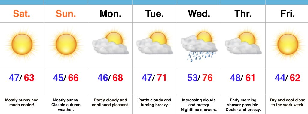
screen-shot-2016-10-08-at-8-03-12-amHighlights:

  • Much cooler weekend
  • Dry conditions continue
  • Next cold front arrives mid week

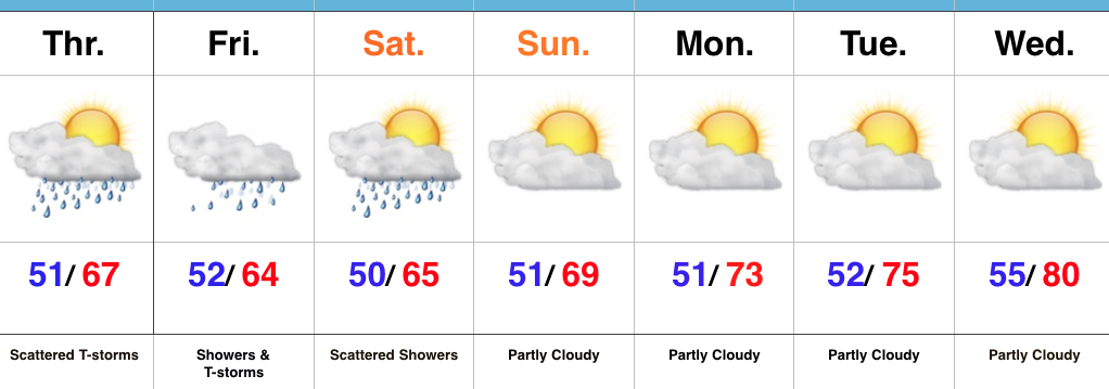
Classic Fall Weather…High pressure is building in to supply a dry and pleasantly cool weekend. Average temperatures this time of year include highs in the upper 60s with lows in the upper 40s.  We’ll run a few degrees below those norms. this weekend with mostly sunny skies in place.  Bon fire, pumpkin patch, or corn maze, anyone?  Perhaps all of the above?!

Dry conditions will remain early next week with slowly moderating temperatures.

Our next item on the agenda is a cold front approaching by the middle of the week.  This front will slide through with showers Wednesday evening into early Thursday followed by resurgent cool air as we wrap up the work week.  Rainfall amounts don’t look impressive, but moisture return will be better than yesterday’s cold front.  We’ll label the rain coverage as “scattered” for now.

Upcoming 7-Day Precipitation Forecast:

  • Snowfall: 0.00″
  • Rainfall: 0.10″ – 0.20″

Permanent link to this article: https://indywx.com/stretch-of-fall-weather/

Not Impressed With Rain Coverage; Much Cooler Weekend…

screen-shot-2016-10-05-at-5-57-22-pmHighlights:

  • Unseasonably warm weather continues for now
  • Much cooler weekend ahead
  • Unimpressed with rain coverage

Feeling More Like It Should By The Weekend…A SW air flow will continue to pump unseasonably warm air into the Mid West as we go through the back half of the work week.  Dry conditions will remain before a cold front serves up a widely scattered shower chance Friday afternoon.  That cold front will sweep through the state Friday evening and much cooler air will spill into the region.  Despite some low clouds and areas of fog Saturday morning, the weekend should feature lots of sunshine along with cool, crisp air.  It’ll be a classic fall weekend in central IN.  Make plans for a bonfire or to visit one of the many popular corn mazes throughout the region.

As we rumble into early next week, high pressure and pleasant weather conditions will remain.

In the tropics, Hurricane Matthew continues to be the headline.  Our thoughts and prayers are with the Bahamas tonight as Matthew roars through.  Tomorrow night and Friday will then feature Matthew coming dangerously close to the east coast of FL.  Landfall or not, those living along the east coast of FL should brace for a long duration and damaging erosion event, along with hurricane conditions.

Upcoming 7-Day Precipitation Forecast:

  • Snowfall: 0.00″
  • Rainfall: 0.10″

Permanent link to this article: https://indywx.com/not-impressed-with-rain-coverage-much-cooler-weekend/

Taste Of Summer Mid Week Gives Way To A Much Cooler Weekend…

screen-shot-2016-10-04-at-7-19-43-amHighlights:

  • Moderating temperatures
  • Not impressed with rain amounts with our front
  • Much cooler weekend

Lots Of Sunshine; Significantly Cooler Weekend…In the short-term, high pressure will supply central IN with a beautiful Tuesday, complete with pleasant conditions and lots of sunshine.

Moisture will begin to return Wednesday with an increasingly moist feel to the air mass as the day progresses.  An isolated shower is possible, especially across western portions of the state, but most of the region should remain rain-free.

Our next opportunity of rain comes Friday as a cold front moves in to close the work week.  As of now, we’re not impressed with rainfall amounts as the front crosses the state.  Our wind will shift to the NW and turn gusty Saturday with much cooler air pouring into the region.  A nice cool, crisp, autumn weekend awaits.  The season’s coolest air thus far will greet us over the weekend.

In the tropics, Hurricane Matthew remains at the forefront.  Those who live along the East Coast (from the FL peninsula all the way up the eastern seaboard) should keep a close eye on forecasts and data over the next few days.

Upcoming 7-Day Precipitation Forecast:

  • Snowfall: 0.00″
  • Rainfall: 0.10″ – 0.25″

Permanent link to this article: https://indywx.com/taste-of-summer-mid-week-gives-way-to-a-much-cooler-weekend/

Welcome To October…

screen-shot-2016-10-01-at-10-02-29-amHighlights:

  • Improving weekend weather
  • Dry, warmer open to the work week
  • Strong late week cold front

Slow Improvements…The “cut off” upper low that’s plagued the region for the past few days will slowly begin to lift north this weekend.  Eventually it’ll get absorbed into the westerlies and get outta’ here!  The end result will be a slowly improving weekend.  Rain coverage will be greater today than Sunday, but less than Friday! 🙂  Slow moving showers and embedded thunder will be most numerous this afternoon before slowly diminishing tonight.  While we’ll have to maintain mention of a shower Sunday, most folks will remain dry.

The work week will get off to a dry start along with moderating temperatures. Highs by mid week will reach the lower 80s as a southwesterly air flow dominates ahead of an approaching strong autumn front.

While timing still needs to be fine tuned, we’re focusing in on the cold front passing through central IN Friday morning.  Ahead of the boundary, scattered showers and thunderstorms can be expected followed by an abrubt NW wind shift and a MUCH cooler air mass for the weekend.  Speaking of cool, it wouldn’t surprise us to see some neighborhood lows into the upper 30s next weekend.

It is October, after all…

Upcoming 7-Day Precipitation Forecast:

  • Snowfall: 0.00″
  • Rainfall: 0.50″ – 0.75″ (locally heavier totals)

Permanent link to this article: https://indywx.com/welcome-to-october/

Rinse And Repeat…

screen-shot-2016-09-28-at-8-43-04-pmHighlights:

  • Continued unsettled and unseasonably cool
  • Drier time arrives Sunday
  • Moderating temperatures early next week

Rinse And Repeat Pattern…Our weather pattern will be dominated by a “cut off” upper low through Saturday.  While it won’t rain the entire time, we’ll maintain mention of scattered showers and embedded thunderstorms each day.  It still appears as if Friday will serve up the most widespread rain coverage.  Similar to today, stronger thunderstorms could contain small hail, especially during the afternoon hours.  Temperatures will remain significantly cooler than normal through the period.

A drier regime will build in late this weekend into early next week. Ridging will continue to expand as we move into mid week with needed dry time and moderating temperatures.  Our next storm system appears to be slated for an arrival next Thursday.  Storms will accompany the front followed by much cooler air.

Upcoming 7-Day Precipitation Forecast:

  • Snowfall: 0.00″
  • Rainfall: 0.50″ – 1.00″

Permanent link to this article: https://indywx.com/rinse-and-repeat/