Category: Forecast

Another Active Week…

screen-shot-2016-10-23-at-8-44-34-pmHighlights:

  • Cool open to the work week
  • Mid and late week fast-moving storm systems
  • Weekend timing questions

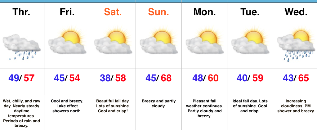
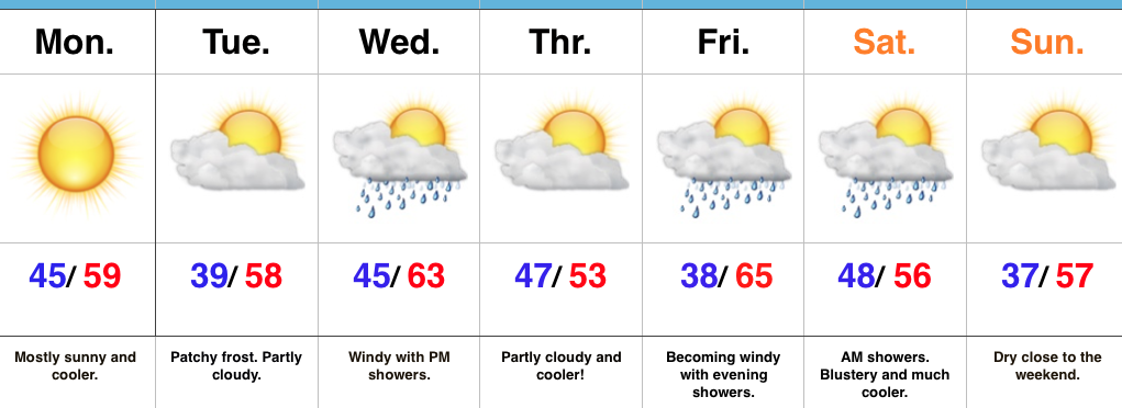
Fall Feel To Open The Week…A dry frontal boundary will pass through central IN late tonight.  Our winds will shift to the NW after midnight and help drive in a cooler air mass to open up the new work week.  Despite lots of sunshine, temperatures will be running below average to open the work week.

A fast-moving storm system will scoot through the lower Great Lakes region Wednesday.  This will help serve to strengthen our winds (SW direction) along with create a chance of scattered showers Wednesday evening.  Another pop of unseasonably cool air will blow into town Thursday.

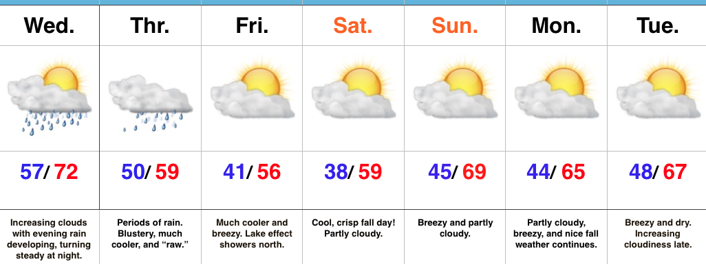
Yet another storm system will press through the region as we get set to head into the weekend. Rainfall totals don’t look particularly impressive, but we’ll lean more towards the Friday night/ Saturday morning storm system as being the better rain-maker of the (2) systems this week.  Cooler air will flow in behind the storm system for the weekend.

Upcoming 7-Day Precipitation Forecast:

  • Snowfall: 0.00″
  • Rainfall: 0.50″ – 0.75″

Permanent link to this article: https://indywx.com/another-active-week/

Increasing Sunshine; Unseasonably Cool Close To The Work Week…

screen-shot-2016-10-21-at-8-33-11-amHighlights:

  • Cool close to the work week
  • Ideal autumn weekend
  • Turning breezy early next week
  • Scattered showers Wednesday PM

Grab The Jacket…After a significant rain event across central Indiana, the weekend will offer up a much-needed time to dry out!  Here’s an illustration of where heaviest rains fell over the past 24-36 hours, courtesy of Weatherbell.com.  Please note these aren’t official rainfall storm totals. Many ground-truth reports into the office include amounts of 1.5″-3″.  Thanks to each of you for your reports!

nws_precip_indy_2
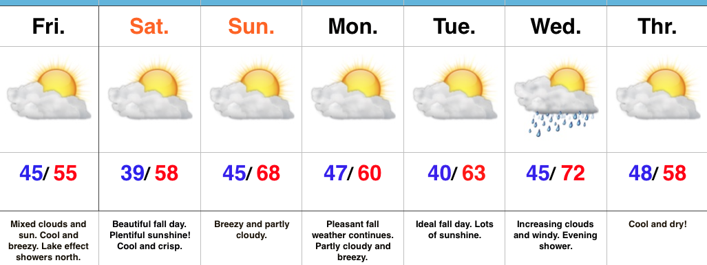
High pressure will build in over the weekend and create an increasingly sunny sky.  The only caveat to that will be today where mixed clouds and sun across central IN become a little thicker and may yield lake effect rain showers across northern portions of the state later this afternoon.

We’ll turn briefly milder Sunday (upper 60s to around 70), but it’ll be a breezy day as a dry cold front sets it’s eyes on the region for a Sunday evening sweep!  Reinforcing cool air will blow in to open the work week, but this should be a rain-free frontal passage as our air mass will be very dry.

The next storm system that could deliver rain arrives Wednesday evening.  Along with scattered showers, a gusty SW wind can be expected before cooler air blows in to close next week.

Upcoming 7-Day Precipitation Forecast:

  • Snowfall: 0.00″
  • Rainfall: 0.10″ – 0.25″

Permanent link to this article: https://indywx.com/increasing-sunshine-unseasonably-cool-close-to-the-work-week/

Much Cooler Feel; Increasing Weekend Sunshine…

screen-shot-2016-10-20-at-7-40-05-amHighlights:

  • “Raw” weather today
  • Increasing weekend sunshine
  • Patchy frost Saturday morning

Wet And Chilly Today…An area of low pressure will track northeast along the Ohio River, into the interior portions of the Northeast between now and Friday.  Additionally, a cold front will continue to press southeast today.  The combination of these ingredients will equal a wet, raw, and breezy day across central IN.  (Definitely NOT a chamber of commerce day).  Temperatures will remain nearly steady through the daytime hours before sliding off relatively quickly tonight.

We’ll wrap up the work week and head into the weekend with increasing sunshine, but the coolest air of the fall season thus far.  Temperatures will grow chilly enough Saturday morning to present a patchy frost threat for outlying areas away from the metro.

Winds will increase Sunday as our next cold front approaches.  The air mass ahead of this front is very dry so we’re not expecting much, if any, precipitation with this next frontal passage (FROPA), but it will serve to offer up reinforcing cool air early next week.

The next storm system that could offer up rain will arrive Wednesday evening.  From this distance, it doesn’t appear to be a heavy rain event.

Upcoming 7-Day Precipitation Forecast:

  • Snowfall: 0.00″
  • Rainfall: 0.75″ – 1.50″

Permanent link to this article: https://indywx.com/much-cooler-feel-increasing-weekend-sunshine/

Much Cooler Times Await On Deck…

screen-shot-2016-10-18-at-6-53-22-pmHighlights:

  • Wet weather moves in from south to north Wednesday PM
  • Raw Thursday
  • Much cooler, fall weather this weekend

Find The Rain Gear…Most of Wednesday will feature dry conditions with lots of sunshine to start, but clouds will be on the increase and rain will follow.  We expect rain coverage to increase from south to north as evening gives way to nighttime.  This is all in association with a surface low developing along a stationary boundary to our south.  This area of low pressure will track along the Ohio River (Thursday) to the interior northeast (Friday).  (Indiana snow enthusiasts know that’s a perfect track for the snowy “goods” if only it was a month, or so, later). We will continue to dream… 🙂

Back to regularly scheduled programming…

Rain will grow in coverage and intensity Wednesday night into early Thursday morning and periods of rain will be with us through the day Thursday.  Heaviest rains should fall through the southern half of the state (where localized 2″+ totals are possible).  The other weather element we’ll have to deal with Thursday is an increasingly chilly and raw northeast wind shifting to the north late.  Temperatures will remain steady and slowly fall by evening.

As the area of low pressure pulls off to the northeast, it’ll help drive the coolest air of the season southward.  Patchy frost is possible for outlying areas Saturday morning.  Fall foliage should be looking “really nice” this weekend across central IN.

Dry, but breezy, conditions will be with us early next week, but we’re eyeing our next storm system by the middle to latter portions of the week.

Upcoming 7-Day Precipitation Forecast:

  • Snowfall: 0.00″
  • Rainfall: 1.00″ – 1.50″ (locally heavier amounts southeast)

Permanent link to this article: https://indywx.com/much-cooler-times-await-on-deck/

VIDEO: Colder Changes To Close The Week; Wet Thursday Ahead…

You must be logged in to view this content. Click Here to become a member of IndyWX.com for full access.  Already a member of IndyWx.com All-Access?  Log-in here.

Permanent link to this article: https://indywx.com/video-colder-changes-to-close-the-week-wet-thursday-ahead/