Category: Forecast

Triple Threat Of Dangerous Winter Weather Ahead…

You can always catch your latest 7-Day Video Forecast in the video player to the right of this post.

We continue to be very impressed with what’s ahead, winter weather-wise, for central Indiana over the course of the upcoming 10 days.  Simply put, what’s at stake is a 10-day period of winter weather that could rival the all time greats in terms of snowfall and cold.  It’ll certainly be interesting to watch things unfold in the days ahead.

Here are some quick-hitting bullet points of what we’re eyeing…

  • Accumulating snow late tonight-Thursday
  • Accumulating snow late Saturday night-Sunday
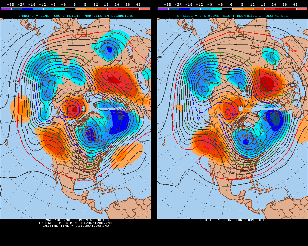
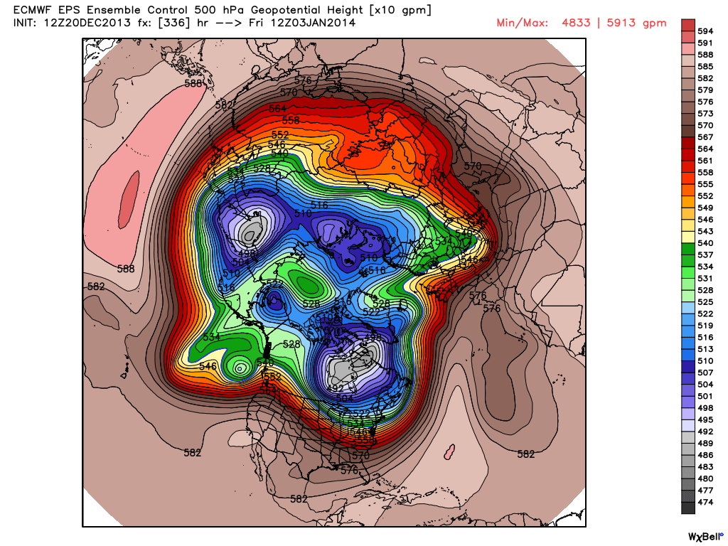
  • Coldest air since 1994 early next week
  • Dangerous cold and wind chill values to 40 degrees below zero

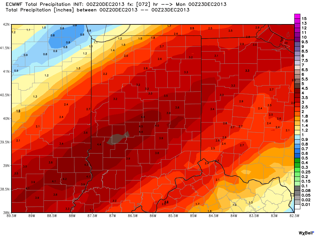
First things first and that’s tonight’s and Thursday’s snow event. We think snow becomes widespread across central Indiana prior to, or around, midnight.  The low pressure system that will aid in snow production across our region Thursday AM is organizing across the central Plains this evening and this will move east northeast with time between now and Thursday morning.

20140101_2130_US_ir


Latest high-resolution simulated model data shows the snow increasing in coverage across central Indiana around midnight.

hires_ref_indy_12


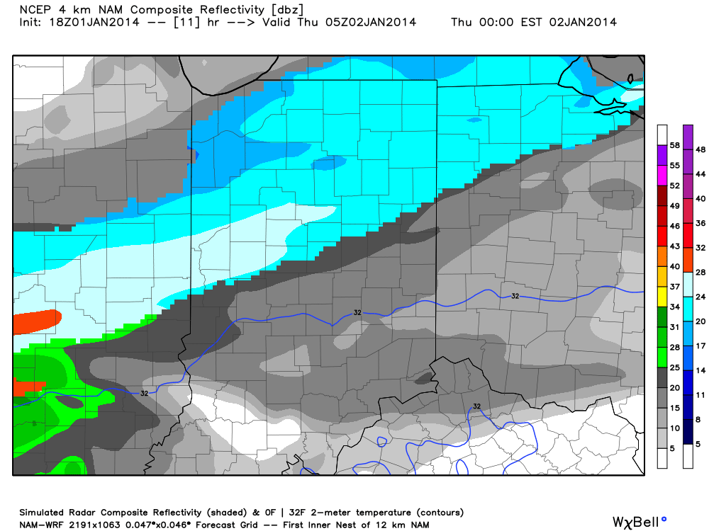
We think the period of heaviest snow comes during the early to mid morning Thursday and will result in a horrible rush period on area roadways.  Accumulating snow ends by noon and is replaced with falling temperatures, gusty northwest winds resulting in blowing and drifting, and scattered lake-driven flurries.

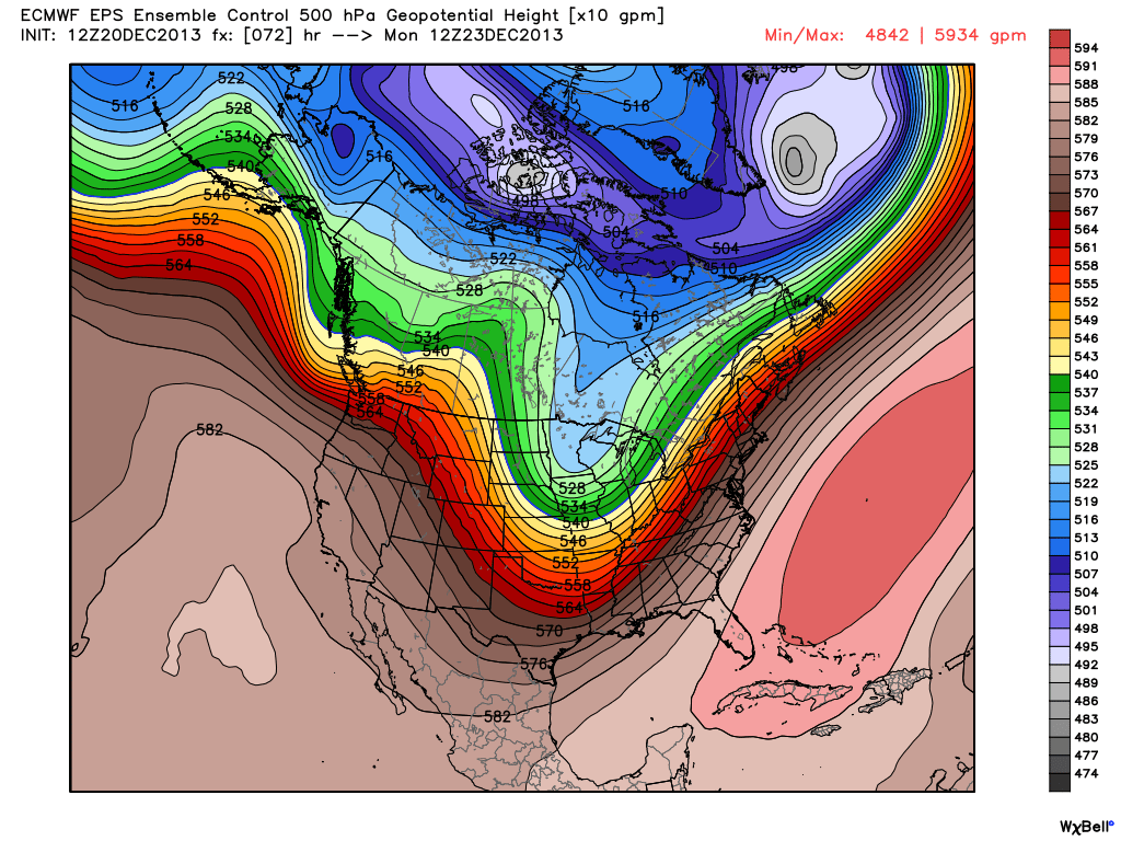
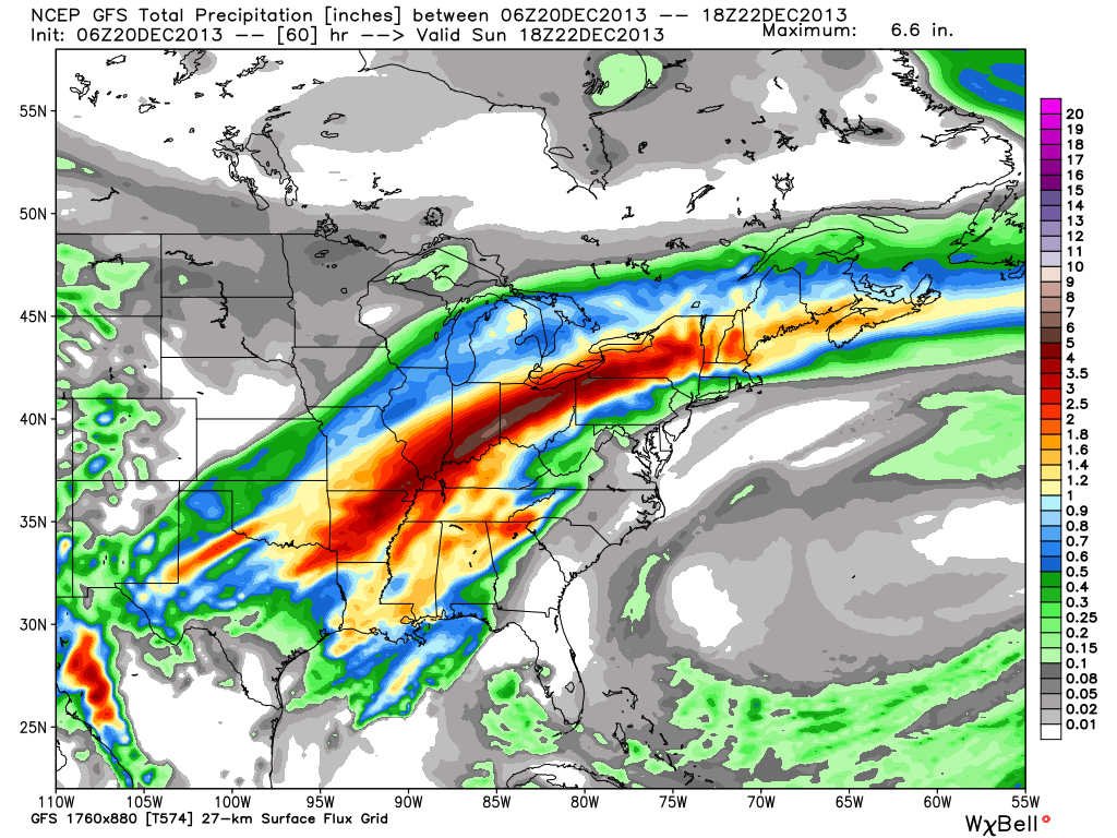
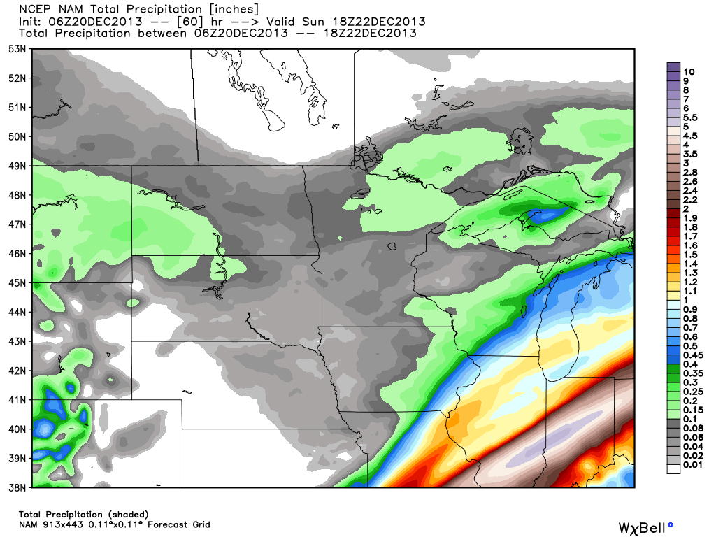
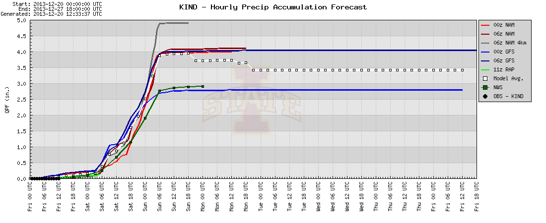
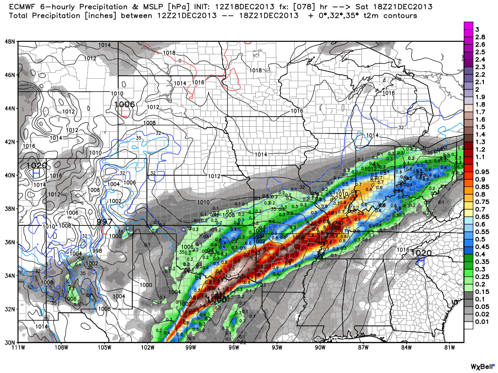
All eyes will then shift to storm number two set to arrive late Saturday night into Sunday.  An arctic boundary will moves towards the region Saturday night and Sunday and help surface low pressure develop.  All of our medium range models (GFS, Canadian, European) are on board with a developing surface low in the Ark-la-tex region late Saturday night/ early Sunday morning and can be seen below.

gfs_ptype_slp_east_16cmc_precip_mslp_east_17ecmwf_slp_precip_mc_17


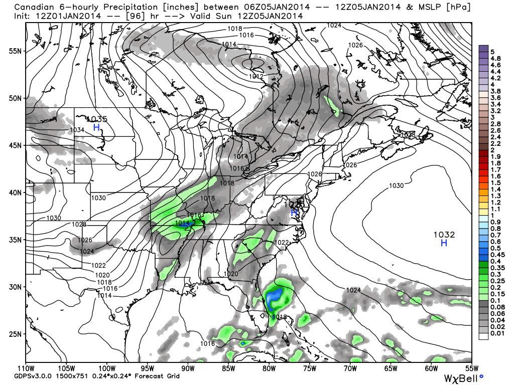
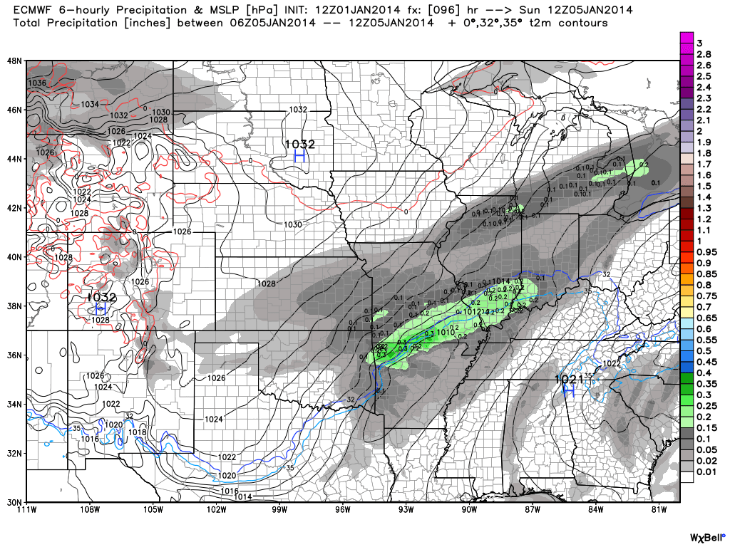
There are still some questions that we have in regards to the extreme snowfall forecasts off some computer models, and we’ll stick with our initial call made here last night of an additional 3-6″ of snow late Saturday night-Sunday for now.  We come up with that range based off an all model blend, including raw numbers, operational data, and ensembles.  An extremely strong arctic high pressure system will be plunging south and will limit how far north the heavy snow makes it.  That said, snowfall ratios and an initial impressive thermal gradient will lead to a heavy snow storm for some parts of the Ohio Valley region Sunday.  Stay tuned.

As early next week approaches (and I’m all settled in to enjoy what I hope to be Auburn’s second National Championship in 4 years), the coldest air since 1994 will be blowing into the region.  Downright dangerous wind chill values of 40 degrees below zero will be possible Monday into Tuesday and result in extremely dangerous conditions to be outdoors for any period of time.

Here’s a look at the latest wind chill idea:

plotter
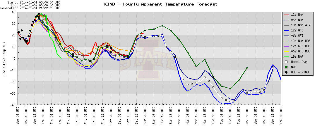
Forecast lows of 15 to 20 degrees below zero will be likely early next week across central Indiana with afternoon highs struggling to make it to zero.

Prepare now for a significant triple threat punch of snow and cold in the days ahead. Stay tuned!

Permanent link to this article: https://indywx.com/triple-threat-of-dangerous-winter-weather-ahead/

Colder Than Normal Pattern Set To Return

Before we go into the cold pattern that is looming, our current forecast of severe flooding developing across central Indiana this weekend remains.  Our projected precipitation numbers remain in the 3-4″ range for most of central Indiana, but there will be some higher totals reported.  Combine that with the recent snow melt and the stage is set for potentially a severe and dangerous flooding event.

As we look ahead to the next weather “challenge,” it has to do with temperatures.  As we’ve talked about in previous posts, our weather pattern flipped to one that has been predominantly colder than normal back in the middle of October.  Despite a handful of days, cold has dominated the pattern.  Before our current thaw temperatures were averaging 5 degrees below normal for the month of December.  While the recent thaw is certain to reduce the anomalous cold, the last week of December could send us right back to readings much colder than average, helping put the exclamation point on the month as far as cold goes.

The latest 8-10 day ensemble plots showcase a very cold pattern to end December.  Cross polar flow gets involved, helping lead to some bitterly cold air around these parts.  We note excellent agreement between the GFS and European forecast models, helping to further increase our confidence in the cold pattern ahead.

test8

But it doesn’t stop there…  We note long range data suggesting this cold pattern continues well into January.

The latest European forecast ensembles showcase the cold continuing to reload into the first week of the month.  This is an impressively cold look, considering we’re still a couple weeks out and that these are a multitude of individual computer model runs averaged together to come up with this solution.

eps_t2min_anom_east_61

As we watch the evolution of the cold pattern, it’s important to turn to the “goings-on” with the upper air pattern.  Note the reorganization of the polar vortex and, equally as important, the placement of the polar vortex.  For the purpose of giving you a couple of different viewpoints of the evolution of the pattern we’ve pasted a Northern Hemisphere and North America perspective.

Note how the polar vortex reorganizes itself and decides to set up shop over Hudson Bay and Baffin Island by early January.  This is significant in that it promotes multiple reinforcing shots of arctic air into the eastern half of the country and backs up what the data above would suggest in the cold pattern that appears to be looming as we move forward…

Sunday, December 22nd

12

Friday, January 3rd

34

What does all of this mean?  That the current “thaw” is very brief.  The seeds were being planted for a return of the cold pattern earlier this week and it all begins Sunday night.  As the data above would suggest, the arctic cold appears to reinforce itself as we go through time and an overall prolonged colder than normal pattern appears to be setting itself up.

Additionally, we’ll have to handle winter storm systems as they come (and they will), but the pattern is one that very well may promote fast-moving clipper systems moving southeast out of Canada.  While most of these clipper systems don’t drop tremendous snowfall totals, the more potent clippers can deposit several inches of snow and serve to “feed back” and turn what’s initially a cold, dry pattern into one that’s suddenly snowy.  We’ll keep an eye on that.  Furthermore, the southern stream may also decide to add a little “excitement” into our forecast late December or early January.

Needless to say, there’s a lot of weather to talk about in the days ahead…

Permanent link to this article: https://indywx.com/colder-than-normal-pattern-set-to-return/

Model Data Not Backing Down On Flooding Rains Ahead

A scan over multiple computer models this morning shows that forecast models remain consistent of the idea of a weekend deluge across central Indiana.  Unfortunately, when combined with the snow melt, if even the numbers are half right, we’ll have to deal with significant flooding this weekend, especially Saturday afternoon through Sunday.

Here’s a look at the data.  We average multiple computer models together to come up with our precipitation forecasts (both rain and snow) that you see in our daily 7-Day Video Forecasts (available to the right of this post).

CAN1EC1gfs_total_precip_east_11hires_ptype_acc_indy_20NAM1plotter

Needless to say, when looking over all of the data above, we still feel confident in the forecast we have out…widespread 3-4″ rainfall with locally heavier totals.  Preparations should have already begun if you live, or work, in a flood prone area, but if not, please do so today.  The question remains not if we’ll see flooding, but how severe the flooding will be.

Permanent link to this article: https://indywx.com/model-data-not-backing-down-on-flooding-rains-ahead/

Thursday Morning Weather Rambles

As always, your latest 7-Day Video Forecast can be found to the right in the video player.   1.) A milder southerly air flow allowed us to remain above freezing…

You must be logged in to view this content. Click Here to become a member of IndyWX.com for full access.  Already a member of IndyWx.com All-Access?  Log-in here.

Permanent link to this article: https://indywx.com/thursday-morning-weather-rambles/

A Lot Of Weather To Talk About…

Mother Nature seems determined to put us weather forecasters to hard work as we get set to head into the Christmas season and welcome in 2014.  We’re tracking a major flood situation that will unfold across central Indiana over the upcoming weekend, followed by a reload of the cold and potentially a storm with a more wintry component as we get closer to the New Year.

First things first and that’s the significant flood threat in the short-term period.  Without trying to go into scare tactic mode, current model data would result in a downright dangerous flooding event for many low lying and flood prone areas this weekend.  Rainfall numbers are extremely impressive with this event and with a deep tropical connection, widespread 3-4″ totals are certainly likely, including some localized higher amounts.  Note the latest European chart, courtesy of the model suite off Weatherbell Analytics.  Needless to say, the Gulf of Mexico is officially “open for business” and will help contribute to excessive rainfall totals and, as stated above, potentially a dangerous flooding event this weekend across central Indiana.

ecmwf_uvz850_noram_16

Latest numbers averaged off a variety of computer models would place just under 4″ of rainfall down by noon Sunday, most of which falls between Friday and Sunday morning.  We note (2) waves of enhanced rainfall intensity set to impact the region.  As of now we’re targeting Saturday afternoon and again late Saturday night/ Sunday morning for extremely heavy rain, shown below.

ecmwf_slp_precip_mc_14ecmwf_slp_precip_mc_17

We still have time to watch the data and monitor the track of the storm.  It’s possible the “heaviest of the heavy” axis of rain shifts somewhat in the days ahead,  but it’s also important to note that even a light to moderate rain event combined with a frozen ground and a solid snow pack still in place will lead to flooding problems here across central Indiana.  The question of whether or not we’ll deal with flooding here this weekend shouldn’t be asked, but instead the question that remains is just how severe will the flooding be?  Stay tuned and if you live or work in a flood prone area, we would recommend preparing now for flooding.

Now, as we look ahead and focus on the Christmas to New Years period our thoughts will shift from a flood threat in the near term to one that’s more wintry.  We’ll turn dramatically colder Sunday afternoon behind the big rain storm and that will set the stage for a colder-than-average run up to Christmas. In fact, latest raw numbers off some forecast model guidance has some frigid readings ahead next week (upper single digits not ruled out for lows).

The upcoming 10 days off the European forecast model charts show an interesting scenario with the coming thaw, but the key word is brief.  Note days 6-10 are back into a colder-than-normal regime.

tavg_anom_ecmwf_conus_1

Additionally, we think we’ll have to deal with another storm prior to the New Year period and with the colder air back in place, there’s the threat we could have to contend with a wintry side to the next storm.  The details with storm number two will have to wait until we finish dealing with the first storm and associated serious flood threat it’s presenting.

Permanent link to this article: https://indywx.com/a-lot-of-weather-to-talk-about/