
 Highlights:
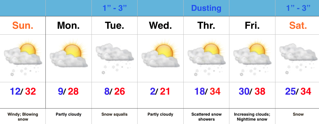
- Arctic air takes control
- Snow bursts overnight Monday-Tuesday
- Late week winter storm brewing?
Bitter Feel; Gearing Up For More Snow…Saturday night’s storm system “split” into two and took one swath of snow across far NW IN while a second (more widespread) area of snow was laid down across central IN. Reports into the forecast office this morning indicate 2″-3″ are common across central IN, with a couple 4″ reports. Thank you for all of the snow reports and photos!
While the snow has stopped, we’ll deal with bitterly cold air and blowing snow the rest of the day. Bundle up and take it slow as you venture out. Temperatures will continue to fall into the teens and wind chill values will fall into the single digits to around zero.
Dry and cold conditions will be with us as we open the new work week, but our next weather maker will blow into town late Monday night and Tuesday morning. We still think intense snow bursts will accompany arctic reinforcements that will send temperatures below zero for some Wednesday morning. It won’t take a lot of moisture to “fluff up” 1″-3″ Tuesday morning. Couple that with gusty winds and falling temperatures and things will likely be messy on area roadways.
Looking ahead, a weak weather system will skirt the area to our north Thursday and could offer up a scattered snow shower, but it’s as we look towards next weekend that things become “more interesting.” Model specifics disagree at this time, but the overall pattern is one that’s conducive to lead to a fairly widespread interior winter storm threat. We’ll have to sort through the details as we go through the week. Stay tuned.
