Category: European Model

Cool And Dry Through Thursday; Weekend Changes…

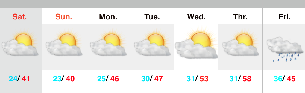
The story through Thursday will be one summed up in two words: dry and cool!  High pressure will supply beautiful weather as we head into the latter portion of the work week.  (May be a good couple days to use some of that PTO :-))!

Temperatures both tomorrow morning and Thursday morning will fall into the 40s.  In fact, some neighborhoods away from the city, itself, may fall to between 38-39 just before sunrise Wednesday.  Unlike today, afternoon cloudiness won’t be an issue and winds will be much lighter.

Changes will ensue as we progress into the weekend thanks to our air flow shifting around to a more southerly and southwesterly direction.  This will pull increasingly humid air northward and we’ll introduce widely scattered showers and thunderstorms into the central IN weather picture Friday afternoon, continuing through the weekend.

1It should be noted, however, that modeling today isn’t nearly as wet and stormy as previous runs.  Will this be proven to be an anomaly, or is the drier trend the correct solution?  We’ll give it a couple more runs before taking things at face value, but feel confident in saying that while scattered showers and thunderstorms will be in the picture, many more dry hours can be expected as opposed to wet and stormy.

Permanent link to this article: https://indywx.com/cool-and-dry-through-thursday-weekend-changes/

Weekend Questions…

Screen Shot 2015-04-14 at 9.38.13 PMNot As Bad As It May Look…Most of the day Wednesday will feature dry conditions and pleasant temperatures.  Moisture will stream in from the south Wednesday evening and nighttime showers will develop across central Indiana, continuing into Thursday (though we can also expect several dry hours).

Friday will also feature mostly dry conditions, but we’ll maintain a mention of a widely scattered shower.  Overall, increasing sunshine and a southerly air flow will help boost temperatures into the lower 70s Friday.

The weekend features lots of questions as two of our more trusted computer models are in totally different camps as of this evening.  The European suggests dry and warm conditions (a great weekend, weather-wise) will rule; however, the GFS model is more unsettled and cooler.  For now we’ll take a blend of the two, leaning more towards the GFS due to better run-to-run consistency.  Stay tuned as updates will be required.

Cooler air will become the story as we open next week and jackets may be needed Tuesday with a gusty northwest breeze.

Upcoming 7-Day Precipitation Forecast:

  • 7-Day Rainfall Forecast: 0.50″ – 1.00″
  • 7-Day Snowfall Forecast: 0.00″

Permanent link to this article: https://indywx.com/weekend-questions/

Cooler Pattern Developing Week 2…

After a warm open to April, we note the MJO is heading into Phase 2 in the medium range.  Phase 2 this time of year would imply for a cooler than normal pattern.

ECMF_phase_51m_small


combined_imageSure enough we see the modeling going towards the cooler look for Week 2 (around 4/17…give or take a day, or two).

Note the GFS ensembles reverse course towards a cooler regime after the warm period currently.

1


2


The European ensembles (left) show a tendency for eastern troughiness, as well.

Geopotential32at32500hPa_North32America_216This isn’t saying some sort of record-smashing cold pattern is coming or anything of that sort, but it is to say that after a warm open to April, we’ll reverse things for a few days, at least, during the medium range period.  This could include a push of frost and freeze conditions, as well.

In the shorter-term, please remain weather aware tonight and keep close tabs on watches and warnings issued by the National Weather Service.  Thunderstorms should push into central Indiana around midnight and will be capable of severe levels, including damaging hail, destructive straight line winds, and quick spin-up tornadoes.

Permanent link to this article: https://indywx.com/cooler-pattern-developing-week-2/

Now We’re Talking…

Screen Shot 2015-03-07 at 10.30.32 AMSpring Fever Anyone?!  A weak weather system is racing through the region this morning.  Clouds and gusty southwest winds are accompanying this, but the air mass is too dry to sustain any sort of precipitation (with the exception of a snow flurry across northern portions of the state).  Sunshine should increase as we progress from morning into the afternoon hours.  Although we’ll remain colder than average this weekend, highs in the lower 40s will feel downright balmy when compared to the bitterly cold times we’ve gone through over the past several weeks.

Early next week will feature a wet weather maker move northeast out of the Deep South, but this should remain east of our region.  We note the European model tries to deliver some light rain Tuesday, but for now we’ll keep our forecast rain-free and dry.

A real surge of “spring fever” will push in here by the middle of the week with highs in the middle 50s Wednesday and upper 50s Thursday (some areas will touch 60 Thursday).  White Leg Warnings will have to be issued, no doubt ;-).

Unfortunately, weather conditions will take a dramatic turn downhill late week into the weekend as a big storm system lifts north out of the Gulf of Mexico.  Colder and raw times are ahead, including a gusty wind-driven rain.  Moderate to heavy rainfall totals appear to be a good bet from 6-7 days out.

Upcoming 7-Day Precipitation Forecast:

  • 7-Day Rainfall Forecast: 0.50″ – 1.00″
  • 7-Day Snowfall Forecast: 0.00″

Permanent link to this article: https://indywx.com/now-were-talking/

Weekend Snow Storm Brewing?

Forecast models for the most part have been much more aligned with this upcoming event, with the exception of a couple runs on Wednesday. Overnight and this morning modeling is…

You must be logged in to view this content. Click Here to become a member of IndyWX.com for full access.  Already a member of IndyWx.com All-Access?  Log-in here.

Permanent link to this article: https://indywx.com/weekend-snow-storm-brewing/