VIDEO: Unsettled Now, But A Beautiful 2nd Half Of The Weekend Ahead…
You must be logged in to view this content. Click Here to become a member of IndyWX.com for full access. Already a member of IndyWx.com All-Access? Log-in here.
You must be logged in to view this content. Click Here to become a member of IndyWX.com for full access. Already a member of IndyWx.com All-Access? Log-in here.
A look over model data from overnight suggests we need to focus on a “leader-follower” event for the upcoming weekend.
We’re confident the “leader” player is a rain maker for IN in the Thursday afternoon-Friday time frame (.40-.70 rainfall potential).

As we progress into the second half of the weekend, details get quite murky on the specifics with the secondary (follower) area of low pressure that develops along a pressing arctic front.
As we’ve been discussing, model solutions will vary within each respected model (GFS, Euro, GEM, etc.) in a run-to-run fashion. Stack them up against one another, and we’ll likely continue to have as many different solutions as we do models that we’re looking at. It’s a byproduct of a pattern transition and that crashing SOI (which is still crashing this morning, btw). Case in point, note the various options below for Sunday.


Past experience with similar patterns certainly leads us to lean more towards the European/ Canadian solution over the GFS from this distance. We know that models have their own biases though. Time and time again the GFS bias is to rush things along a bit too much from this distance and become too progressive. On the flip side, the European is notorious for dragging it’s heels a bit and, at times, can be too slow with bringing energy out of the west. This in return impacts things downstream…
From this distance, we still can’t be too specific with snow/ precipitation prospects Sunday. While confidence is increasing on at least some sort of snow to contend with, the significance of such isn’t possible to iron out at the moment. Much fine tuning will be required. Stay tuned.
Finally, it’s a cold start to the day, and feels like a mid December morning should! Temperatures are running significantly behind where we were across the east this time yesterday.
 Highs today will only climb to around freezing across central Indiana. Add in a stiff NW breeze and wind chills will be colder. Grab the coat before heading out to finalize that Christmas shopping.
 This cold is coming in the face of what’s been a very warm month. Meteorological winter, as expected, has opened warmer than normal.
 By the way, we think changes towards colder loom mid and late January on. That likely carries us into spring this year with winter continuing.
Christmas week is coming into better focus now, and the “blend” of model solutions was, indeed, the best path to take. The European’s blow torch 70 degree idea was laughable. Still warmer than normal, Christmas morning should start in the middle 30s with highs in the upper 40s.
The lead up to Christmas will be an unsettled one after a dry weekend. Moisture returns Monday.
 Another surge of moisture comes in advance of a cold front and associated area of low pressure Christmas Eve before colder air oozes in.
 Christmas morning opens chilly, but dry, as high pressure is overhead.
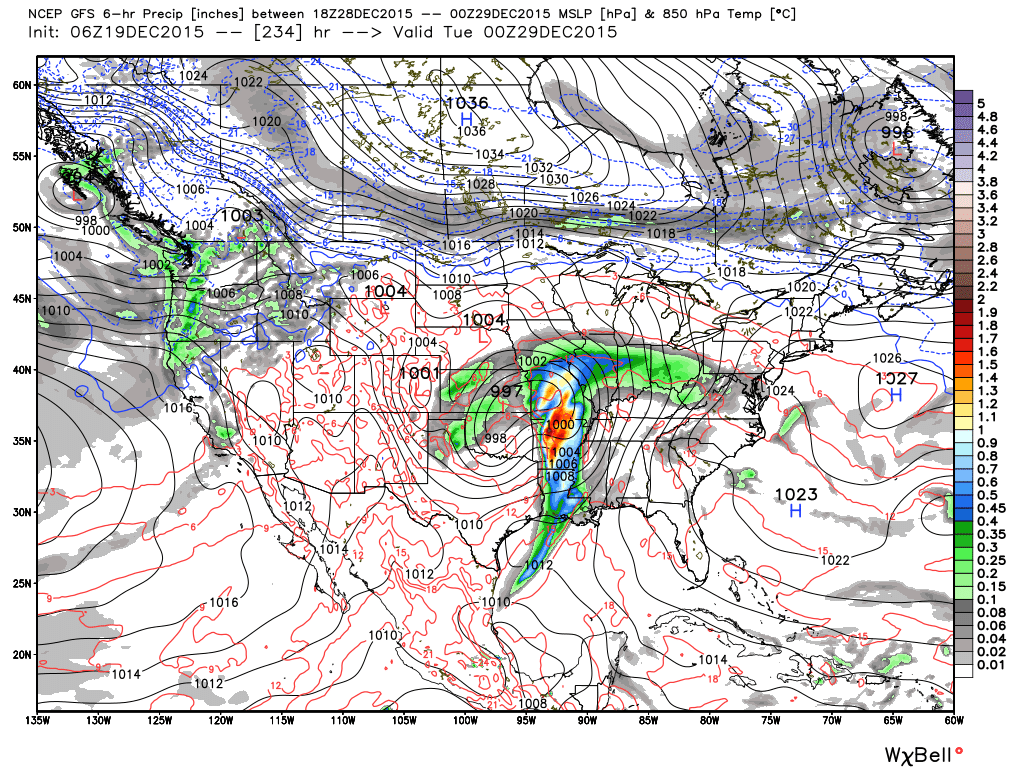
 Looking ahead, an active close to 2015 appears to be in the cards. Model solutions at this distance have ranged from a major winter storm to a flooding rain threat. We’re not confident on either idea at this point. Without blocking, it’ll be mighty tough to get anything wintry from this storm, and we also note models have been overdoing rainfall totals in the 5-10 day range as of late. That said, is this the storm that can begin to set us up for the expected overall pattern change to winter coming in January?
Note the wild differences between the GFS, GEM, and European for the storm leading up to New Years.

 When we turn to the ensembles to attempt to gain a clearer picture of what we can expect, we see they are of no help either.
 Are we confident of a storm coming to wrap up 2015? Absolutely, but, again, far less confident on the specifics from this distance. An overall wetter than average pattern is likely, however.
 To wrap things up this morning we still note a favorable SST profile for wintry conditions mid and late winter. In other words, hang in there winter fans. 🙂
 By the way, a major crash is coming that will send us into a La Nina by the second half of 2016. The implications this can have are vast, and include an active severe season and big time Atlantic tropical season.


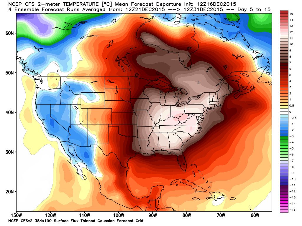
Before we get into the thinking behind our set-up for Christmas, we want to be very clear in saying the overall warm pattern will continue as we head through the holiday season and into early parts of 2016. We do see signs of changes brewing that could (and should) lead to a dramatic flip of the coin for the second half of winter. With a weakening Nino, it’s also likely that the cold and wintry changes last deep into spring this year, but that’s for another discussion down the road.
In the grand scheme of things, mid and long range model data strongly suggests a very warm pattern remains across the eastern half of the nation, while cold dominates the west, through the end of 2015.

 Just to be clear, we’re very confident on the medium range warmth to wrap up the year (and most likely open 2016). Contrary to how confident we are on the overall warm pattern through the mid range, we’re much less confident with the shorter term pattern that encompasses the all-important Christmas Eve – Christmas Day forecast. Getting right to the point, the American GFS forecast model suggests we’re dealing with a FROPA (frontal passage) Christmas Eve night that sets up a blustery, colder Christmas with morning snow flurries possible. The GFS says we make it into the lower to middle 40s for highs Christmas. On the flip side, the European model (usually, but not always, more accurate than the GFS) says we blow into early summer-like levels with highs around 70 degrees Christmas, including a mostly dry forecast with strong southwest winds. How does an afternoon BBQ sound Christmas with that sort of idea?!
When we get down to the dirty details, the differences all have to do with the way the models handle the eastern (Bermuda) ridge. A snap-shot of the 8-10 day ensemble composite (that shows the Euro, GFS, and Canadian) highlights small, but significant, differences with the ridge placement.

The GFS model (and Canadian, as well) suggests we’re dealing with a more progressive pattern Christmas that results in the cold “sloshing” it’s way east much quicker than its’ European counterpart. Meanwhile, the European model says the eastern ridge flexes it’s muscle going into the Christmas period and results in the warmer, breezy solution as opined above.
When we dig in further, experience tells us we should “raise an eyebrow” to both solutions. How many times have we seen the biases that both models have impact the mid to long range forecast? The GFS has an eastern (more progressive) bias while the European has a western (slower) bias. Hint: It’ll be important to remember that as we rumble into more active cold and wintry times come mid and late in the season.
To sum things up, while we’re supremely confident in the long term warm pattern to wrap up the year, we remain very cautious with either solution currently being portrayed by either *normally* more-trusted mid range models. Lets give it a couple more days and see where things go. I wish we could be more certain with that all-important Christmas forecast, but we simply can’t at this juncture. Both solutions have been very consistent with their respected idea for the past couple days. One thing’s for sure and that’s that we’ll be looking at a major model bust sooner rather than later…
You must be logged in to view this content. Click Here to become a member of IndyWX.com for full access. Already a member of IndyWx.com All-Access? Log-in here.