A busy weekend awaits as stormy Saturday evening give way to a 12-18 hour period of potentially damaging wind gusts. Rain will end as wind-whipped snow to close the weekend…
You must be logged in to view this content. Click Here to become a member of IndyWX.com for full access. Already a member of IndyWx.com All-Access? Log-in here.
Recently, a “transient” pattern has dominated. This has kept any sort of long-lasting cold at bay and resulted in above normal precipitation. As we get set to close out February and welcome in a new month, a pattern change is on the horizon.
This overall shift in the pattern will drive a more sustained and significantly colder than normal regime southeast. In short, cold is set to “overwhelm” the pattern through the first couple of weeks of March. In the most extreme case (especially if we can get snow down), we will be able to challenge records at some point during the 1st (10) days of the month.
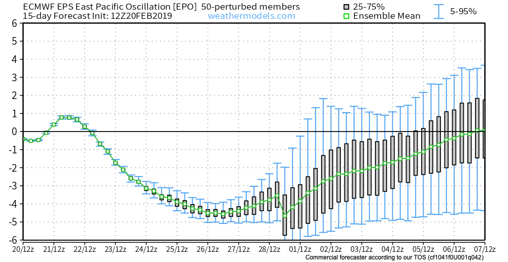
In spite of a neutral to positive AO and NAO, a significantly negative EPO and MJO rumbling through the cold late Feb and early March phases look to trump the otherwise warm signals. We also can’t forget about the significant SOI crash. Let’s dig into some of the latest data:
CFSv2
Note the modeling spreading the cold out during the Weeks 2-3 time period before gradually modifying things as we move into the middle and latter portion of March. The mean storm track shifts to the east during the first couple of weeks of the month (pattern will likely be dominated by more snow vs. rain events during this time period) before wetter than normal conditions return for the 2nd half of the month.
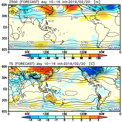
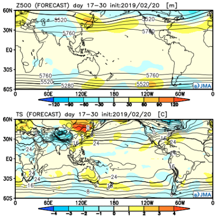
JMA Weeklies
Week 1
Week 2
Weeks 3-4
Like the CFSv2, the model overwhelms the pattern with cold during the Week 2 time period. Also similar to the CFSv2, the JMA Weeklies bring ridging back into the East and associated warmth by mid-month. While we haven’t included the precipitation anomalies in this post, the model does bring wetter than normal conditions back into the area by mid-March.
European Weeklies
The NEW European Weeklies remain consistent from Monday’s update (and data above) in delivering a very cold 1st half of March. The core of the cold looks to be centered over the upper Midwest and Northern Plains, but temperatures for the balance of the first couple weeks of the month will likely resemble what we’d expect in late January or early February vs. March. While precipitation will likely run below normal (thanks to the cold pattern), the model deliver above normal snowfall during the period. As we move into the 2nd half of the month, warmer (and wetter) conditions are shown to return.
Given all of the above, we expect the primary upper air pattern to feature a central and eastern trough through the 1st half of March before that trough settles into the West during the 2nd half of the month. This will open up the eastern portion of the country for not only warmer air, but a return of moisture-laden storm systems and the potential of strong-severe storms at times.
While arriving later than originally expected (recall we originally thought the cold, wintry pattern would start on the 18th), it sure appears as if this was a case of “delayed, but not denied.”
The latest GFS and European ensembles are keying in on a significant pattern change as we put a wrap on February and open March. (Looks like we were about a week early in jumping on the cold bandwagon).
First and foremost, there’s excellent overall agreement amongst data (increases confidence significantly during the medium to long range period).
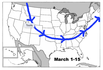
Days 1-5: Southeast ridge continues to dominate during the short-term period and there’s no high-latitude blocking to speak of. This suggests storms will continue to “cut” northwest of the region and place central Indiana in the “warm” sector, with transient, backlash cold/ snow potential.
Days 6-10: Significant changes begin to take place as heights (ridging) builds across AK. This is important as it can help “dislodge” late season cold air (and send it southeast). The SE ridge is also in the process of getting squashed during this period. We’ll likely transition away from the moisture-laden storm systems and replace with faster, overall weaker, systems that will be more capable of producing wintry precipitation.
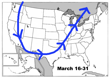
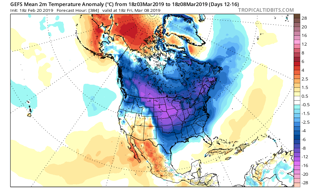
Days 12-16: A total transformation of the pattern has taken shape since the Day 1-5 period. The new ‘mean’ trough position takes up shop across the East with the AK ridge continuing to dislocate late season arctic air southeast. The GEFS also shows a reflection of a southwest ridge which can be helpful in the overall storm track that could potentially deliver more “meaningful” wintry systems across the OH and TN Valleys as we get into the first couple weeks of meteorological spring.
Side notes: We’ve reviewed the crashing SOI index and this increases our confidence in a much colder pattern developing (typically takes place around 10-12 days after the crash begins). We’ve noted the deeply negative values against the base state which would suggest the cold pattern should continue for some time. We still believe the pattern remains colder than average, overall, through the 1st half of March.
The latest deeply negative EPO adds fuel to the fire in the idea of a cold open to March.
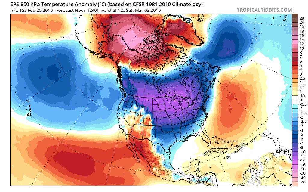
Given this, there should be no surprise to see the cold anomalies showing up on the latest medium-long range ensemble guidance:
It sure appears March will come in like a lion; will it go out like a lamb?
A wintry mix this morning sets the stage for another active week of weather across central Indiana. We also look forward to late Feb and early March…
You must be logged in to view this content. Click Here to become a member of IndyWX.com for full access. Already a member of IndyWx.com All-Access? Log-in here.
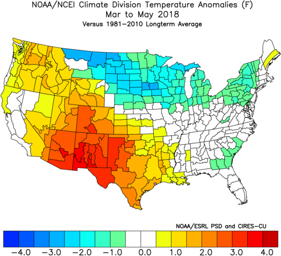
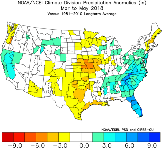
Last spring was a tale of two seasons in itself. March (featured a foot of snow) and April were significantly colder than normal and then we shifted things to summer in May (the last month of meteorological spring was close to 10 degrees above normal). As a whole, it was a quiet severe weather season.
Despite the wild swings, at the end of the day, things “balanced out” nicely across the central Ohio Valley, including central Indiana.
As we look ahead to what the 2019 version holds, here are a few headlines that have our attention:
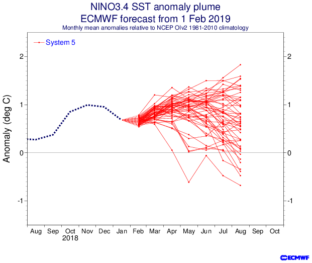
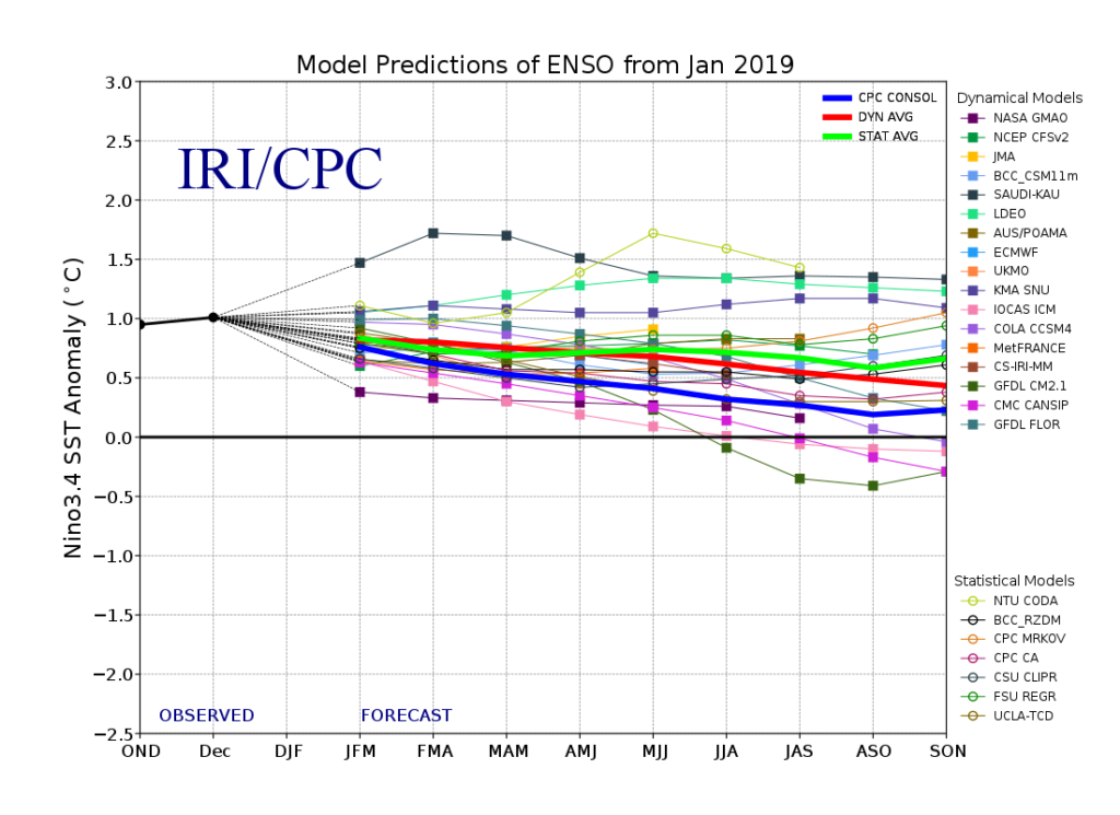
I. Weak Nino is behaving more like a Nina (Tropical Northern Hemisphere pattern can be thanked for this).
II. Neutral NAO is expected
III. Neutral PDO (Pacific Decadal Oscillation)
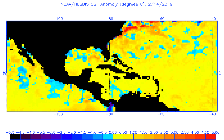
In addition, we’re paying special attention to the SST configuration in the Gulf of Mexico. A warmer than average GOM can most certainly lead to a more “hyper” severe weather season as spring gets going.
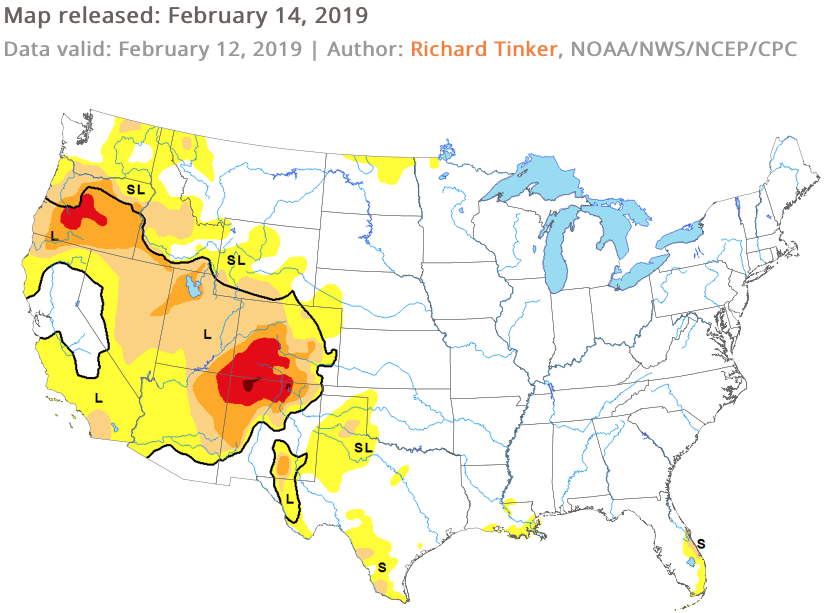
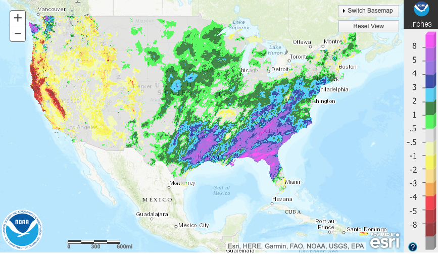
The late winter/ early spring drought monitor can give a hint where early warmth may try and get going. However, this year, we can’t rely on this tool as the Plains and East, including the heart of the #AGbelt, have seen copious amounts of moisture over the winter.
Drought Monitor as of 2/14/19December 2018 Precipitation AnomaliesJanuary 2019 Precipitation Anomalies
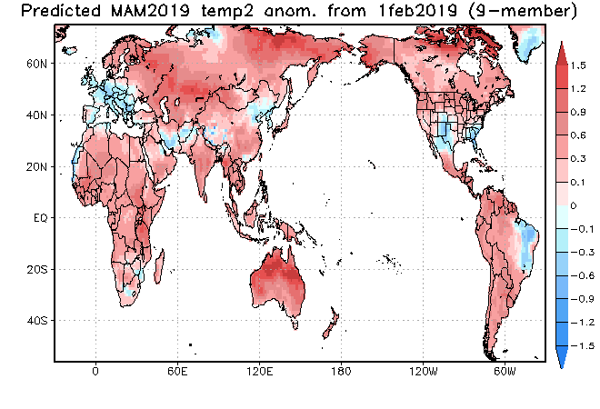
Let’s look at what the model guidance is printing out for meteorological spring:
JMA
March
April
May
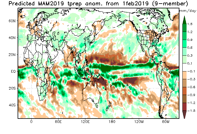
CFSv2
JAMSTEC
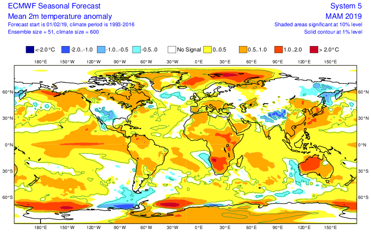
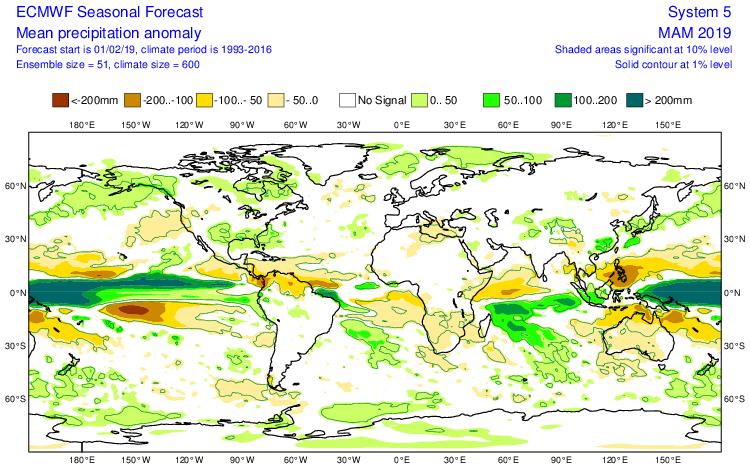
European Seasonal
Summary
We anticipate a slightly warmer than average spring season across not only central Indiana, but the Mid West and Ohio Valley region, as a whole. A weak El Nino is expected to persist into the upcoming summer and the conditions typically associated with such should eventually show themselves (as opposed to more of a Nina-like flavor now) through the spring. We agree with the consensus of model guidance above that March is likely to feature the coldest temperatures, relative to normal, and that’s primarily due to what should be a colder 1st half of the month before more bonafide spring conditions take hold the 2nd half of the month. Precipitation is anticipated to run near average, if not slightly below average, levels through the spring. As for severe weather, we expect a much busier season than last year, especially with the warm SSTs lurking in the Gulf of Mexico.