Updated 01.05.25 @ 8:21a Type: Impactful wintry weather A significant winter storm will impact central Indiana today and Monday. What: Heavy snow; Heavy wintry mix downstate When: Sunday morning through…
You must be logged in to view this content. Click Here to become a member of IndyWX.com for full access. Already a member of IndyWx.com All-Access? Log-in here.
Updated 01.03.25 @ 6:12p Type: Impactful wintry weather Storm Total liquid from a model “blend” What: Heavy Snow; Heavy Wintry Mix Downstate When: Sunday morning through Monday afternoon Temperatures: Low…
You must be logged in to view this content. Click Here to become a member of IndyWX.com for full access. Already a member of IndyWx.com All-Access? Log-in here.
Wind: Potential of straight line winds in excess of 60 MPH
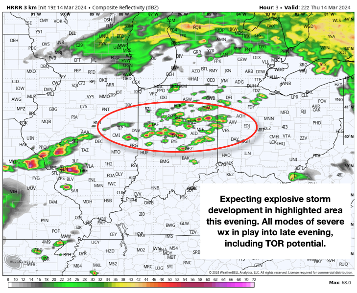
Temperatures: Lower 70s falling into the 40s after midnight
Summary: While all is quiet on the radar as we type this, things will change quickly through the next hour, or so. We anticipate storms to initialize across the region around 6p and quickly intensify. Downstream radar and satellite trends pose a concerning look this afternoon, including several super cells and this activity is expected to expand into central IN through the evening. All modes of severe weather are possible, including large hail, damaging winds, and a few tornadoes. Please heed all warnings and have your severe weather safety plan activated through the evening. Thankfully, we still anticipate rapidly improving conditions north to south towards 11p to midnight.
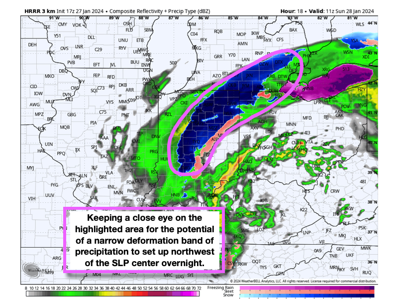
An area of low pressure continues to organize in northeastern MS this afternoon and will move northeast into the lower Ohio Valley before transferring energy off to a secondary (and eventually “primary”) low that will take control Sunday off the Mid-Atlantic and southern New England coast.
Rain will lift north into central Indiana through the late afternoon and evening, falling moderately at times tonight. As just enough cold air pours into the backside of the low, rain will transition to a wet snow after midnight. We note high resolution guidance is also becoming more “excited” about the potential of a narrow deformation band of precipitation that may setup shop across portions of central Indiana into northeastern parts of the state Sunday morning. If this does, indeed, take place, a wet “thump” of snow to the tune of 1″ to 2″ can be expected by 9a Sunday. That said, even hours away from this event, “bust potential” is still much higher than normal. Should we not realize the narrow band of heavier precipitation rates, it’ll be difficult if not impossible to get the column to cool enough to generate a band of accumulating snow.
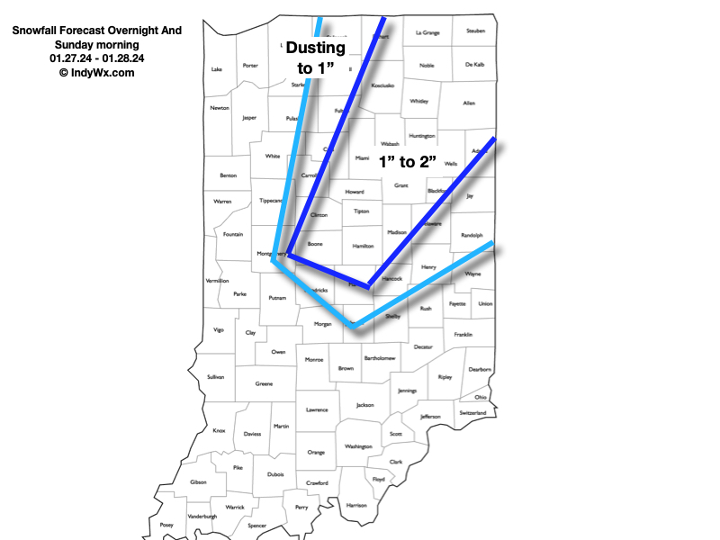
All in all, still a far cry from anything significant, but this could surprise a few folks Sunday morning all the same. Most, if not all of this wet snow will be confined to grassy and elevated surfaces, but there could also be a few slick spots early Sunday morning during periods of heavier snowfall rates.
Speaking of Sunday, we turn quite blustery with northwesterly winds gusting upwards of 30+ MPH and highs in the middle 30s. Dry conditions will return after the early morning snow departs.
Saturday will once again dawn on a gloomy note, with cloudy skies, areas of dense fog, and drizzle, but we’re not looking at measurable rainfall across central Indiana until we…
You must be logged in to view this content. Click Here to become a member of IndyWX.com for full access. Already a member of IndyWx.com All-Access? Log-in here.