Client Brief: Impactful Winter Weather Event Sunday Evening Through Monday…

Type: Impactful Winter Weather
What: Accumulating snow; mixed wintry precipitation

When: Sunday evening through Monday

Temperatures: Lower to middle 30s

Wind: East 10 to 15 MPH, shifting to the north Monday night with gusts to 25 MPH

Blowing/ Drifting: Minimal
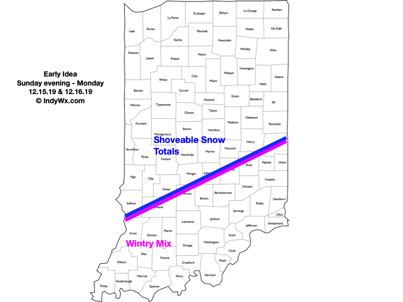
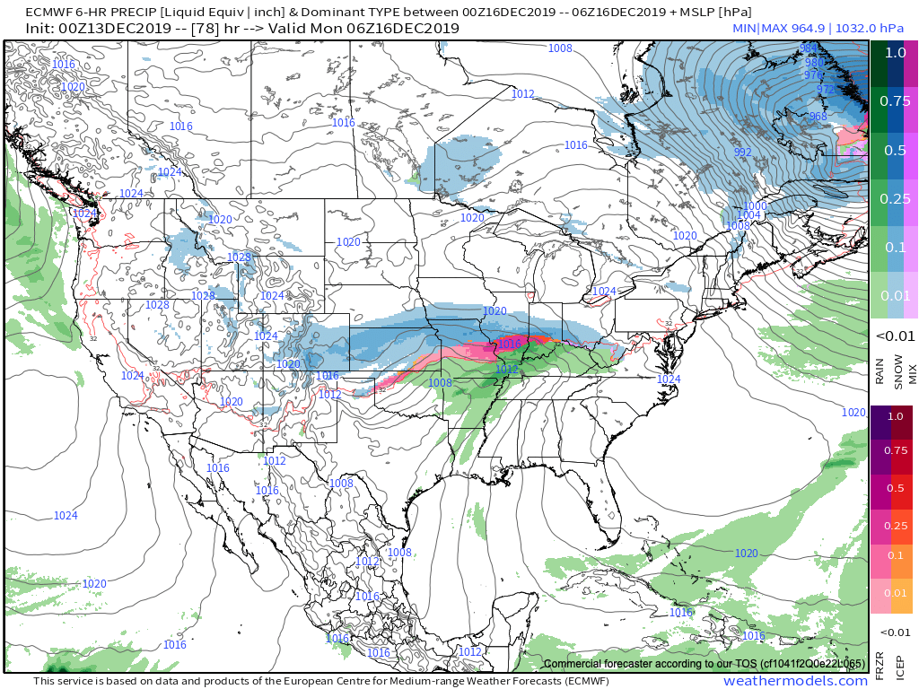
We continue to closely monitor the potential of an impactful winter weather maker Sunday evening through Monday. Initially, we think “overrunning” precipitation will overspread central Indiana Sunday afternoon and evening. This should fall in the form of snow for most. As the surface low draws closer, precipitation will increase in intensity Sunday night into the day Monday. The all-important track of the surface low appears to take a path from western Arkansas Sunday night, along the Ohio River Monday morning and into western Pennsylvania by Monday night. This is a favorable track for accumulating snow across portions of the state. The map above features our “ridiculously” early idea on best chances where the heavier snowfall will occur (shoveable totals seem like a good bet for places in and around Indianapolis and points north). Downstate, enough warmer air should get pulled into the system for a time Sunday night into Monday morning that a wintry mix of precipitation (sleet, snow, and rain) is expected to cut down snowfall totals. As the storm pulls up to our northeast, gusty northerly winds will develop with lingering snow showers in Monday night, along with colder conditions.

We’ll have an updated video post later this evening and will keep close eyes on data not only today, but straight through the weekend.

Confidence: Medium-High

Next Update: This evening (Video)
Client Brief: Damaging Wind Gusts Arrive Tonight-Wednesday Morning…

Type: Damaging Wind

What: Wind gusts in excess of 50 MPH

When: Tonight into Wednesday morning 

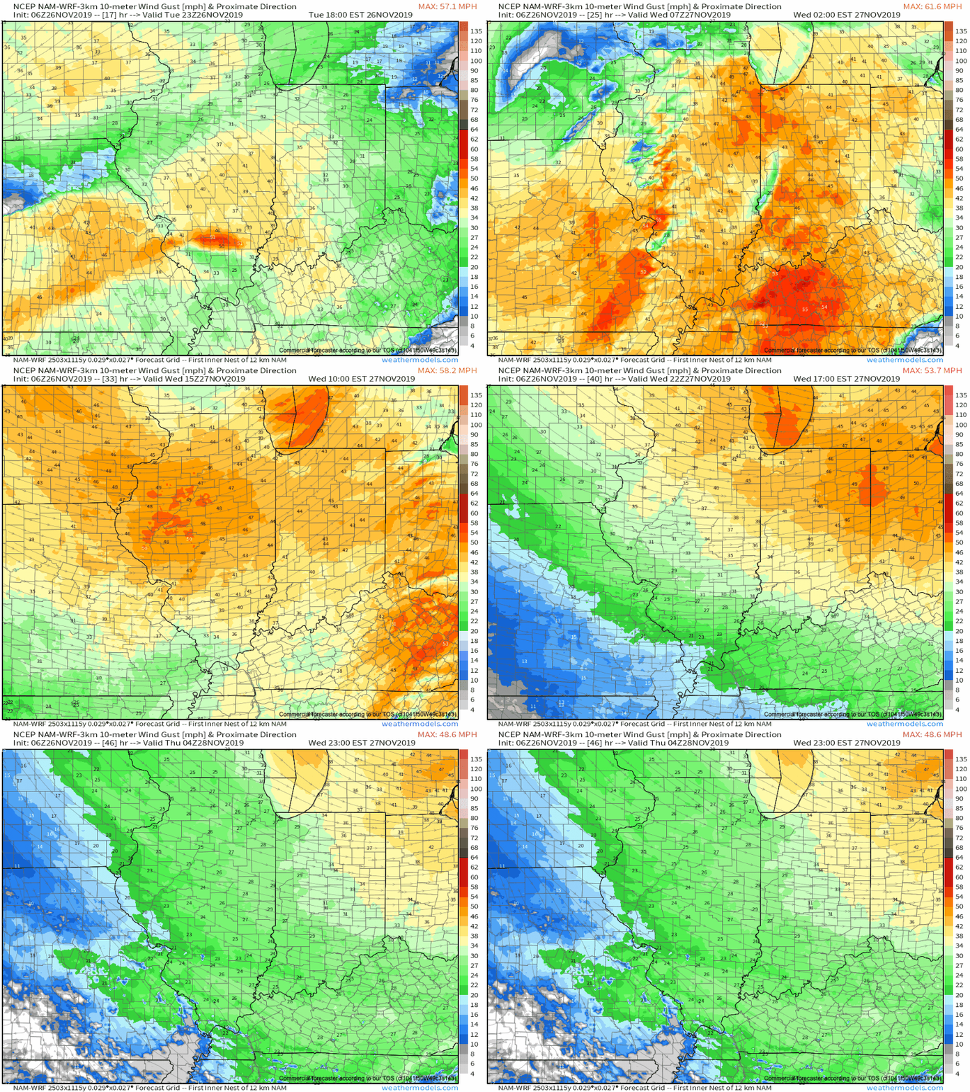
Wind: Winds will increase this evening, gusting to 40 MPH before sunset. Southwest winds will gust to 50 to 55 MPH overnight into the predawn hours Wednesday. Wind speeds will slowly begin to diminish as we move into Wednesday afternoon.

Power Outages: The combination of wet ground and strong winds will likely lead to scattered power outages across central Indiana tonight and Wednesday.

A few light showers will move southwest to northeast across central Indiana later this afternoon, but it’s not until just after sunset when rain should become more widespread. We’ll likely even introduce some thunderstorms into the mix after midnight. Most of central Indiana can expect 0.50″ to 0.75″ of rain with the passage of this storm system. The bigger story will be the wind. It’ll become increasingly gusty as we progress through the afternoon and evening (30-40 MPH gusts), but gusts will reach potentially damaging levels tonight into the predawn hours Wednesday. It’s during this time period when we anticipate 50 to 55 MPH gusts across central Indiana. Rain will end by mid-morning Wednesday and wind speeds will begin to slowly diminish. 40-45 MPH gusts are still a good bet into mid-afternoon before gusts subside Wednesday evening. Finally, colder air will arrive Wednesday morning and leftover moisture may fall as a few snow flurries into the afternoon Wednesday.

Confidence: High

Next Update: Video discussion this evening

Client Brief: Wet Snow Develops This Afternoon Into The Evening…

Type: Impactful Winter Weather

What: Accumulating wet snow

When: This afternoon into early evening 

Temperatures: Falling from the upper 30s early afternoon to around 30° by late evening.

Wind: North 20-25 MPH

Blowing/ Drifting: Non-existent to minimal

Pavement Impacts: Salting required. Plowing will also likely be needed across east-central Indiana.

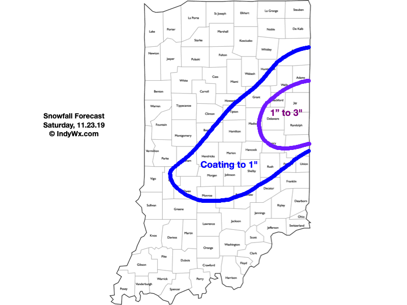
There’s an old saying in the weather business of an “upper low being a weatherman’s foe.” That’s particularly true early and late in the season due to the added complexities of marginally cold air typically available. As we discussed over the past week, the dynamics and cold air these type of systems can manufacture also creates added headache. Many instances these kind of systems result in essentially a “now cast” scenario. With all of that said, our confidence is increasing after another look at overnight model runs to put out the snowfall forecast above. Rain will overspread central Indiana late morning into the early afternoon, however, as the precipitation rates increase, we’ll notice a transition to wet snow this afternoon into the evening. There could also be a brief wintry mix, including sleet, during the transition to wet snow. Banding features will likely develop late afternoon into early evening leading to heavier snowfall across east-central parts of the state where we have the 1″ to 3″ snowfall forecast up. For the remainder of central Indiana, most should be closer to a coating with a few 1″ reports. The snow will exit even far eastern areas before midnight.

Confidence: Medium

Next Update: This afternoon

Client Brief: Weather Goes Downhill Quickly Monday PM…

Type: Impactful wintry weather

What: Accumulating snow

When: Monday afternoon into Tuesday morning

Temperatures: Falling from the lower 40s around daybreak into the lower 20s by late evening.

Wind: North shifting to the northwest and gusting 20-25 MPH.

Blowing/ Drifting: Minimal

Pavement Impacts: Salting and plowing will be required

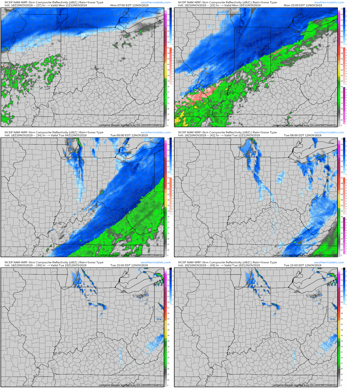
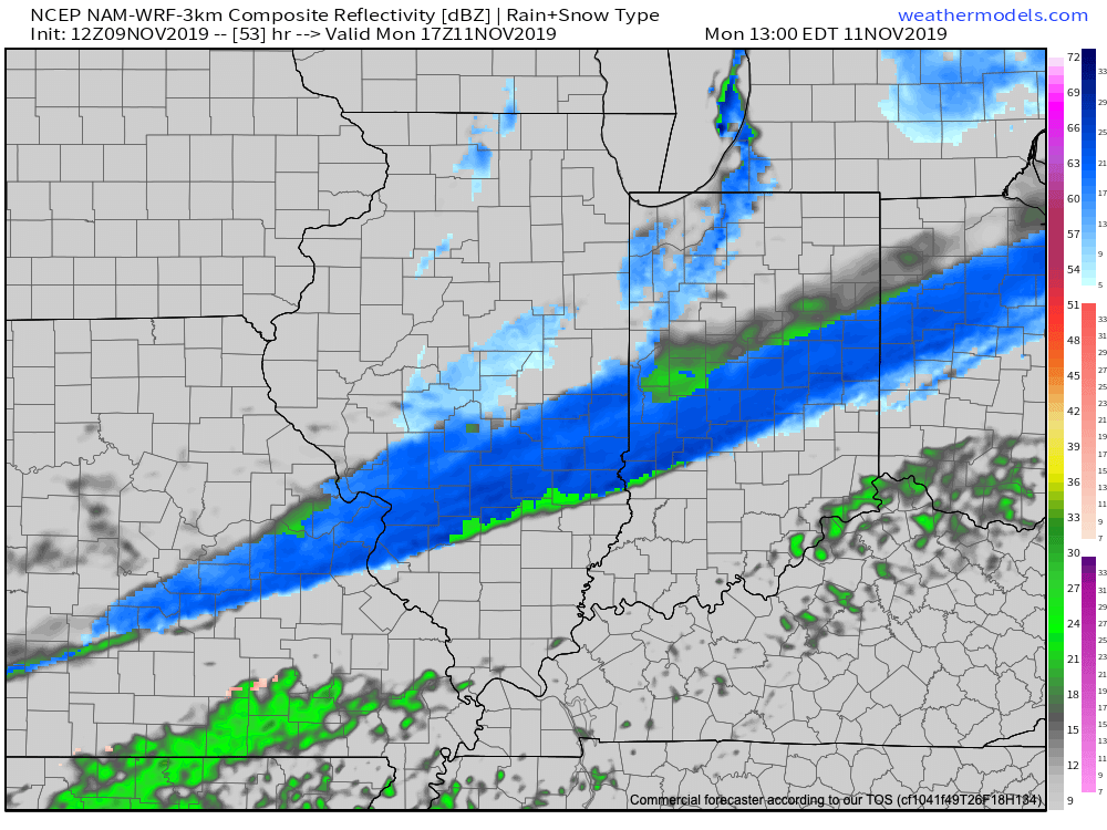
We type this with a quiet and pleasant early-November evening underway, but major changes await on deck. An arctic cold front will continue to press south through the state during the overnight period. Monday will dawn with overcast and dry conditions across immediate central Indiana, along with a stiff northerly breeze. That said, a cold rain will develop by mid morning and this will transition to wet snow around or just after lunch north of the city and early afternoon for the city, itself. Some embedded banding is possible within the snow shield Monday afternoon into the evening hours, thanks to a strengthening surface wave moving northeast along the arctic front. This will create the potential of heavier snow rates around the evening rush. Combine this with the fact temperatures will be falling into the 20s around this time frame and it’s a safe bet that weather will create a high impact on evening travel Monday all throughout central Indiana. The “system” snow will diminish off to the southeast late evening, but by this time, lake effect streamers are expected to pivot across central Indiana before eventually setting up shop across east-central and northeast Indiana Tuesday morning. Record cold will follow the fresh snow with a low Tuesday and Wednesday mornings between 10° to 15°.

Confidence: High

Next Update: Monday morning

Client Brief: First Accumulating Snow Of The Season…

Type: Impactful wintry weather

What: Accumulating snow

When: Monday

Temperatures: Falling from the upper 30s into the 10s by Tuesday morning.

Wind: North shifting to the northwest with gusts of 20-25 MPH.

Blowing/ Drifting: Minimal

The first accumulating snow of the season (for at least most of central Indiana) awaits Monday. While this won’t be any sort of blockbuster winter storm, it’ll likely have some impacts due to the first accumulation of the season, along with plummeting temperatures Monday evening into Tuesday morning. Monday will start dry with cloudy skies and a stiff north breeze, but snow will overspread central Indiana late morning into the early afternoon. A burst of steady to moderate snow is possible into the early afternoon hours. Temperatures will crash from the upper 30s just after daybreak into the upper 20s by the evening rush. Snow will begin to diminish from north to south around 5p to 6p. Please note, the above “1st call” doesn’t include the additional lake effect snow that will follow for the northern IN snow belt. While heavy snow isn’t expected, local slick spots will develop on untreated surfaces as temperatures continue to plummet into the 10s during the overnight period.

Confidence: Medium

Next Update: Late Saturday night or early Sunday morning