VIDEO: A Cold Weekend Is On Tap; Looking Ahead To Thanksgiving Week…
You must be logged in to view this content. Click Here to become a member of IndyWX.com for full access. Already a member of IndyWx.com All-Access? Log-in here.
You must be logged in to view this content. Click Here to become a member of IndyWX.com for full access. Already a member of IndyWx.com All-Access? Log-in here.
As we rumble through the remainder of 2016, a “transient” weather pattern awaits. Cooler, more seasonable, air is working itself into the Ohio Valley today and will be followed by another (stronger) cold front Thursday. That front will pack more of a punch in the cold department, along with providing opportunity for snow showers, as well. That said, we’re still about a week off from more of a sustained cold pattern.
With the arrival of the new year, a new weather pattern will emerge as well…
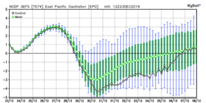
The EPO (East Pacific Oscillation) and WPO (West Pacific Oscillation) will flip back to negative phases as the New Year arrives. This will help drive the shift, initially, to a colder regime, locally.
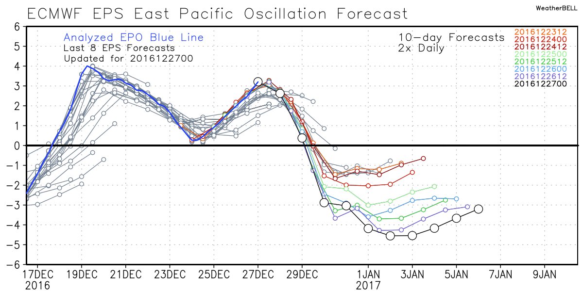
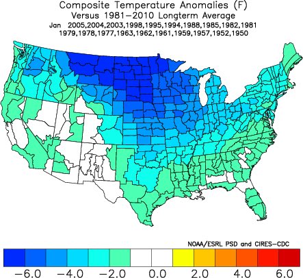
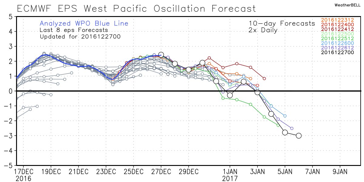
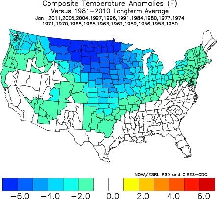 Accordingly, we see the ensemble data flipping to a colder pattern over the upcoming (10) days. Note the low anomalies in the higher latitude regions today (Image 1) versus Day 10 (Image 2).
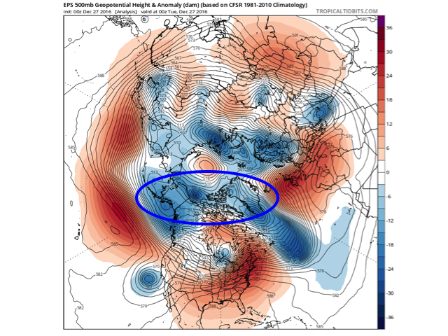
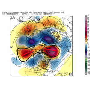
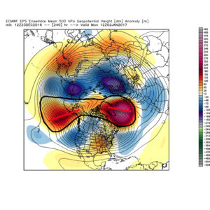
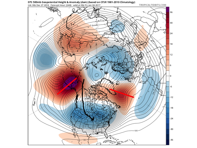 The pattern developing by Day (10) is one capable of producing another frigid regime- only January style. Cross-polar flow sets up shop and, unlike, December, some blocking is noted, as well. This can help the mean storm track shift further south. (Bye-bye Great Lakes cutters, though Mid Western and Ohio Valley Snow Lovers will find a new worry in the form of suppression potential ;-)). Individual storms will have their respected challenges, as always. As a whole, it’s a very cold, stormy look and a pattern capable of leading to an expanding snow pack across the Lower 48.
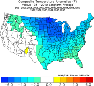
Notes: The new European Weeklies are in and reflect the general idea here of a more sustained cold, wintry pattern unfolding as January arrives. The Weeklies are very cold through Weeks 2-3, in particular. As far as snow goes, they also suggest an active storm track with numerous storms leading to an increasingly snowy regime through the middle parts of January, as well. That said, we’re a bit hesitant to focus too much on the long-term snowfall details as the Weeklies have been too generous in the snow department over the past several weeks. As a whole, it’s very tough to argue the pattern isn’t one that should yield the snowy “goods” in the coming weeks though.
More later!
 Highlights:
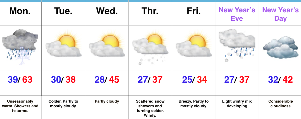
Wet At Times Today…A cold front will push across the state later this afternoon. Ahead of the front, a warm southwesterly air flow will lead to a spring-like feel on this day after Christmas. Coverage of showers will increase by late morning and around lunchtime, including the possibility of an embedded thunderstorm. Once the front sweeps through the region, our winds will flip to the northwest and result in a cooler feel as early as tonight. Tuesday will feature much more seasonable conditions.
Reinforcing chilly air will blow into town Thursday afternoon and with enough upper level energy around, we’ll mention scattered snow showers in our forecast. Colder weather will be with us to close the week and head into New Year’s weekend.
Speaking of New Year’s, we still eye a storm system around New Year’s Eve. Confidence is low in the overall set-up in regards to storm track and timing and fine tuning will be required. For now, we’ll simply go with a developing light wintry mix Saturday and “sure up” the details later this week.
Upcoming 7-Day Precipitation Forecast:
 Highlights:
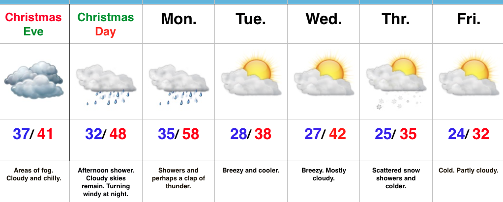
Ah, Christmas Eve…From our home to yours, we wish you a very merry Christmas and a blessed holiday season. It’s hard to believe Christmas Eve is upon us. Despite areas of fog and an overcast, chilly day, weather really won’t present much of a challenge, locally, for travelers or last-minute shoppers (surely we don’t have any of those in central IN). 😉 Rudolph will be needed tonight as areas of fog and low clouds remain across portions of the state.
Conditions will remain damp and chilly into Christmas as most of the day remains in the 30s. Our air flow will shift to the south Christmas afternoon and provide a late day boost on the thermometer into the 40s after dark and near 50 by midnight. As we see the southerly wind erode the chilly conditions in place we’ll also have to be on the look out for a passing shower Christmas afternoon.
Better shower coverage will push in ahead of the cold front Monday morning. An embedded clap of thunder is also possible. Winds will shift to the NW with the passage of the cold front Monday afternoon and cooler air will spill into central IN Monday night. That high you see in the upper 50s will come just prior to the frontal passage.
After the mild start Monday, seasonable temperatures will return next week. Models are struggling with handling a piece of energy the middle of next week. We’ll keep an eye on it over the next day or so. Scattered snow showers will likely accompany a push of colder air Thursday.
Upcoming 7-Day Precipitation Forecast:
*A fresh 7-day will be updated late tonight or early Christmas Eve.*
Modeling continues to suggest a colder return looms as we close out 2016 and open 2017. We’ve discussed the implications of a negative EPO and it certainly appears as if, at least initially, the negative EPO will do the “dirty work” to drive a colder regime in the 6-10 day period.
 We note ensemble data is suggesting high latitude blocking tries to develop towards Day 10. Recall this was the missing ingredient in the bitterly cold blasts of air that occurred during the first few weeks of December. Both the GEFS and EPS agree on the increasingly blocky look to the pattern by Day 10. This would help drive a cold, stormy pattern by early January. Instead of storms cutting, we would see more suppression. With a “stubborn” southeast ridge, things could get interesting across the Ohio Valley from a wintry perspective….
 We don’t want to jump the gun, but it the positives can “hook up” over the pole, we stand the chance of locking into a rather lengthy cold, snowy regime as we rumble deeper into the heart of winter.
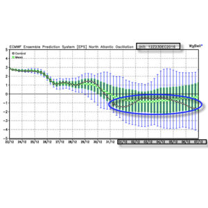
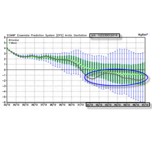
Given the look, it’s no surprise we see the 12z teleconnections want to continue the trend of a negative look to the NAO and AO in the medium to longer term.
 Summary: A rather mild regime remains as we rumble through Christmas before trending more seasonable next week. From a wintry perspective we need to continue to keep an eye on the period around New Year’s Eve/ Day. Confidence continues to increase on the potential of a return of arctic air come early January.