VIDEO: Reinforcing Chilly Air Blows In Tomorrow Night; Touching On December…
You must be logged in to view this content. Click Here to become a member of IndyWX.com for full access. Already a member of IndyWx.com All-Access? Log-in here.
You must be logged in to view this content. Click Here to become a member of IndyWX.com for full access. Already a member of IndyWx.com All-Access? Log-in here.
 Highlights:
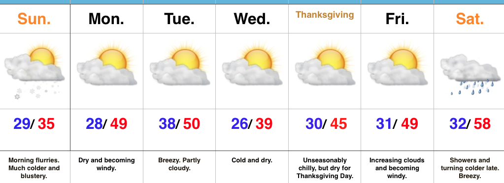
November Or December?! A strong cold front is slipping southeast as we type this forecast Saturday afternoon. This will result in a much colder close to the day, along with wrap around moisture transitioning to wet snow later this evening across central and northern portions of the state. Sunday will start off with scattered flurries and snow showers before dry conditions quickly return. It’ll be an unseasonably cold and blustery day.
As folks begin to travel for the upcoming Thanksgiving Day holiday, high pressure will provide an extended period of dry and rather uneventful conditions. A dry cold front will pass through the state Tuesday and help reinforce the chill for Thanksgiving, itself. While we’ll notice gusty breezes at times this upcoming week, precipitation will be hard to come by.
Our next threat of precipitation will arrive this time next week as a cold front moves south. Expect showers Saturday, followed by a wind shift and coldest air of the season by the second half of next weekend.
Upcoming 7-Day Precipitation Forecast:
You must be logged in to view this content. Click Here to become a member of IndyWX.com for full access. Already a member of IndyWx.com All-Access? Log-in here.
 Highlights:
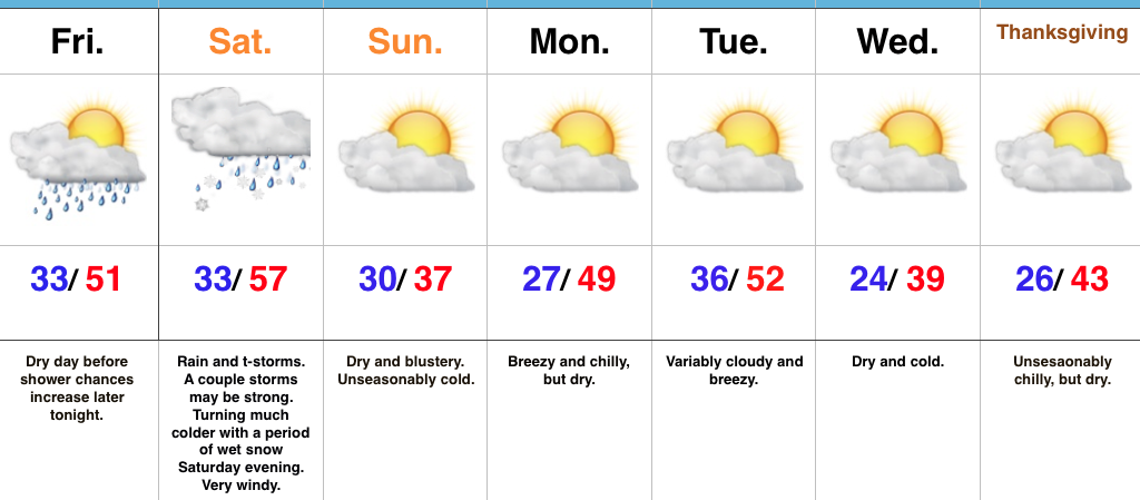
Storms To Snow This Weekend…An approaching storm system will lead to an active open to the weekend. Beforehand, thankfully, we’ll close the work week out on a rather quiet note. The daytime hours will remain dry before moisture begins to return this evening. An initial round of showers will move across central Indiana (thinking between 8p-9p) before steadier and heavier rain and embedded thunderstorms blow into town Saturday. A strengthening surface low will move from the central Plains tonight and into the southern Great Lakes Saturday. This will lead to a briefly milder surge of air Saturday morning into the early afternoon before a cold front sweeps through the state and leads to a sharply colder close to the day. Right ahead of the cold front, a skinny, but potentially intense, line of thunderstorms will track across central Indiana late Saturday morning into early Saturday afternoon. Damaging wind gusts are possible as this thin line of storms advances across central and southern Indiana. Winds will then shift around to the northwest and help drive much colder air into the region through the afternoon and evening. In fact, we’ll turn cold enough to allow precipitation to end as a touch of wet snow Saturday evening.
We’ll wrap up the weekend and kick off Thanksgiving week on a much calmer note. Chilly high pressure will build in Sunday, allowing sunshine to return, but temperatures will run around 15° below normal. A dry cold front will pass through the state Tuesday. With the exception of a wind shift and a few more clouds we really shouldn’t expect much more in the way of “excitement.” This will allow unseasonably cool air to return for Thanksgiving, itself.
Upcoming 7-Day Precipitation Forecast:
You must be logged in to view this content. Click Here to become a member of IndyWX.com for full access. Already a member of IndyWx.com All-Access? Log-in here.