Category: AG Report

Weekly #AGwx And Severe Weather Outlook…

Updated 07.24.21 @ 7:23a

The ‘mean’ upper air pattern will feature a persistent trough over New England with a ridge (hot dome) across the central Plains in the upcoming 7-day period.
Well above normal temperatures will be anchored across the central Plains and points north and west through the upcoming week. New England will feature below normal temperatures. After a hot start to the week, temperatures will cool late week, locally.
Above normal rainfall can be expected across the Great Lakes region into New England.
In general, we forecast between 0.50” and 0.75” of rain in the upcoming 7-day period across central Indiana, but there will be locally heavier amounts.

Forecast Period: 07.24.21 through 07.31.21

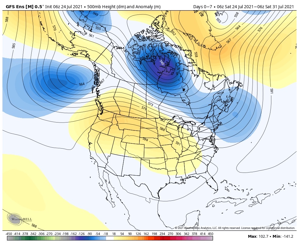
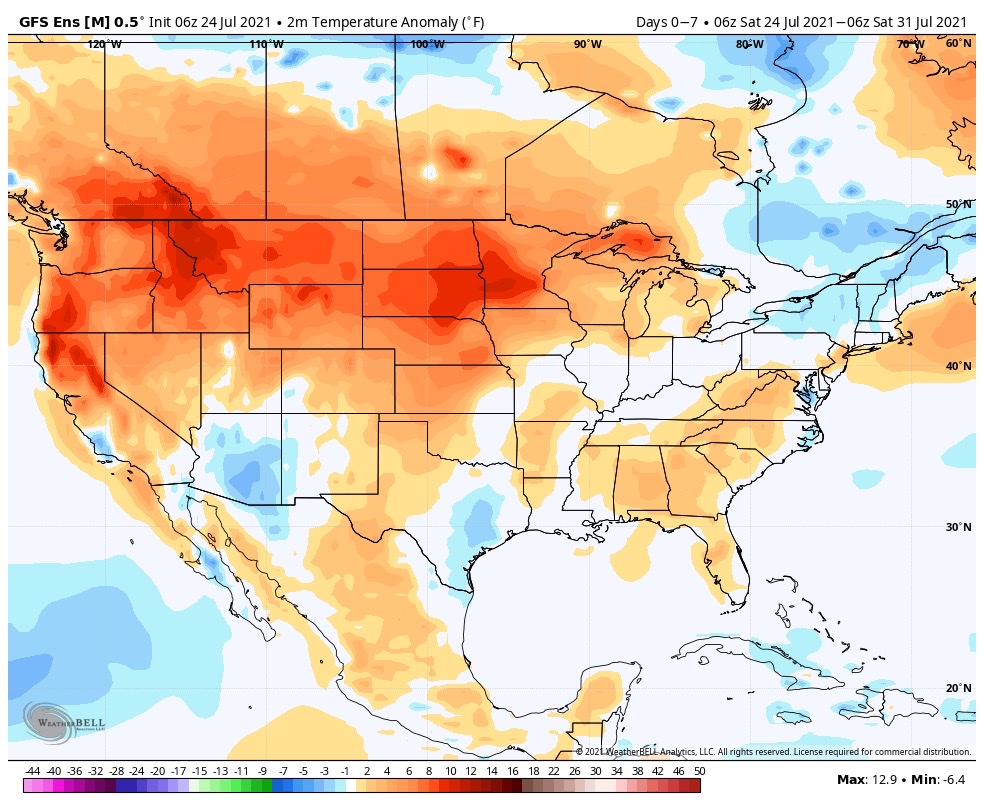
The upcoming 7-day period will place the Great Lakes and Ohio Valley in a northwest flow aloft. This is a notorious pattern for “ridge riding” thunderstorms to roll right into the general region (and sometimes during the hours not typical for storms this time of year – overnight and early morning). While it’s impossible to say exactly when and where these potential storm clusters may track, we’ll keep a watchful eye on the short term period through midweek across our general area. Sometimes these storm clusters are capable of more widespread damaging wind. While the most persistent, serious heat will be well off to our northwest, we can expect a few hot days to open the forecast period (low 90s) before we cool significantly late next week and into next weekend.

Permanent link to this article: https://indywx.com/weekly-agwx-and-severe-weather-outlook-40/

Weekly #AGwx And Severe Weather Outlook…

Updated 07.18.21 @ 7:48a

The upper pattern over the upcoming 7-days will feature a persistent ridge across the West with a trough across the East, tailing back into the South.
It’s a tale of 2 different stories this week from a temperature standpoint: cooler than normal across the East into the southern Plains while heat bakes the northern Plains.
The active pattern will take at least somewhat of a breather to open the new week, locally. The heavy rain/ active storm track will shift south and impact the TN Valley/ Deep South. Wetter than normal conditions are also noted across New England, and monsoonal moisture will plague the Four Corners.
Most central Indiana rain gauges can expect to accumulate between 0.25″ and 0.75″ of rain in the upcoming 7-day period.

Forecast Period: 07.18.21 through 07.24.21

We’ll finally see a period to dry things out to open up the new week. That’s a good thing as we’re running a whopping 3.7″ above normal, month-to-date. High pressure will supply increasing sunshine and eliminate rain chances from our forecast today through Tuesday. Our next opportunity of showers and thunderstorms will come Wednesday as a frontal system scoots through the area. We’ll then get back into a more active stretch as a northwest flow aloft offers up the chance of southeast moving storm clusters to impact our weekend plans. We’ll need to monitor things as we get closer. In addition to a heavy rain threat, this kind of upper pattern has been known to support storm clusters that can also pack strong winds on the leading edge. The other big story this week will be a continued lack of heat. Before we get back to stormy times, the Sunday through Tuesday stretch will truly feature “chamber of commerce” type weather by late-July standards. Get out there and enjoy!

Permanent link to this article: https://indywx.com/weekly-agwx-and-severe-weather-outlook-39/

Weekly #AGwx And Severe Weather Outlook…

Updated 07.11.21 @ 8:18a

Persistent ridges will remain in place along both the East and West Coast with a persistent trough in the central through the upcoming 7-day period.
The cooler anomalies in the central will be mostly associated with lower than average daytime maxes (due to the unsettled weather). Hot weather will remain in place across the West.
Above normal precipitation can be expected through the Ohio Valley, Great Lakes, and interior Northeast through the course of the upcoming 7-days.
We forecast widespread 2″ to 3″ rainfall totals across central Indiana through the upcoming 7-day period with locally heavier amounts.

Forecast Period: 07.11.21 through 07.18.21

A persistent and rather stagnant upper pattern will remain in place through the upcoming 7-day forecast period. A cut off upper low that will be responsible for our unsettled conditions to open the work week will lose it’s influence on our weather as it gets absorbed in the westerlies by midweek. This will result in coverage of showers/ storms going from “numerous” (now through Tuesday) to “isolated” Wednesday and Thursday. Don’t get used to the drier trend though as a new trough will settle into the Plains during the 2nd half of the week, increasing coverage of showers and thunderstorms yet again Friday through next weekend. With such a rich, tropical airmass in place, the threat of localized flash flooding will remain high.

Permanent link to this article: https://indywx.com/weekly-agwx-and-severe-weather-outlook-38/

Timing Out Weekend Rain And Looking Ahead At The Pattern For The Remainder Of July…

Updated 07.09.21 @ 8:13a

Drier and cooler air will be with us to close out the work week, but changes are on the horizon just in time for the weekend.

It still appears as if we will deal with a couple rounds of more widespread showers and thunderstorms Saturday. The first complex will likely impact central and southern Indiana Saturday morning (bracketing the hours of 8a to noon west to east for round 1).

High resolution guidance then delivers a 2nd round of showers and thunderstorms into the state during the late afternoon and evening hours.

A moist southerly flow will continue to impact the region into early next week, keeping periods of scattered showers and embedded thunder in our forecast Sunday through Tuesday (most numerous during the afternoon and evening hours).

While we can’t completely rule out rain Wednesday, coverage should be less compared to what we’ll see in the short-term period. Rain and storm coverage will then ramp back up the 2nd half of the week into next weekend. All in all, it’s a very active pattern that will undoubtedly produce localized flash flooding across portions of the region.

7-day precipitation anomalies
We forecast 7-day rainfall totals between 2.5″ and 3.5″ with locally heavier amounts.

Looking ahead, all indications continue to point towards above normal rainfall as we progress through the latter part of July. As has also been the case, we don’t see any sort of sustained heat on the horizon through the end of the month.

Permanent link to this article: https://indywx.com/timing-out-weekend-rain-and-looking-ahead-at-the-pattern-for-the-remainder-of-july/

Weekly #AGwx And Severe Weather Outlook…

Updated 06.27.21 @ 9:42a

The upper level pattern this week will feature troughiness in the central portion of the country while a significant high pressure ridge continues to bake the Northwest with unseasonably hot, record-breaking temperatures.
Record heat will continue to bake the Northwest while unseasonably cool temperatures will be welcomed into the Front Range, southern Plains, and along the Gulf Coast.
We forecast widespread rainfall amounts between 1.5″ and 2.5″ across central IN in the upcoming 7-day period, but there will be locally heavier totals.
Well above normal precipitation can be expected ahead through the period from the southern Plains into the Great Lakes, TN Valley, and Mid-Atlantic.
While ingredients aren’t in place for a widespread severe weather event, one or two cells could pulse to severe levels later this afternoon across the northern half of IN, including an isolated tornado, given the parameters.

Forecast Period: 06.27.21 through 07.04.21

A frontal boundary will remain draped across the general area through the middle part of this week. While subtle differences will remain regarding greatest concentration of shower and thunderstorm coverage each day, it’s a safe bet most of the region will see a passing shower or storm at some point each day this week. We’ll keep an eye on radar trends this afternoon for the possibility of a local severe weather warning (threat is primarily going to be centered on western and northern parts of the state). Eventually the front will get shoved south and we’ll welcome in drier, cooler air as we get ready to kickoff the long Independence Day weekend. In fact, overnight lows will likely fall into the lower 50s for some by the weekend with highs only in the low-mid 70s. Rain chances will persist Friday and Saturday before we dry things out in earnest for the holiday, itself.

Permanent link to this article: https://indywx.com/weekly-agwx-and-severe-weather-outlook-36/