Category: 7-Day Outlook
 Highlights:
- Breezy open to the work week
- Moderating temperatures
- Weekend rain chances
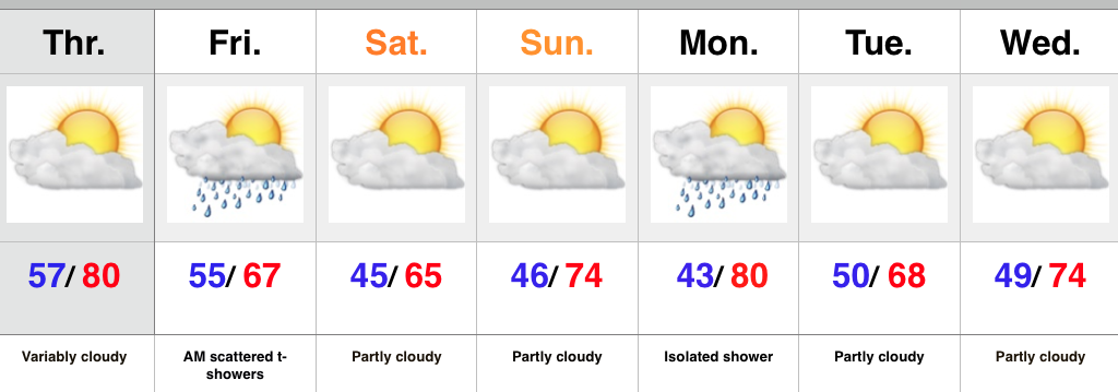
Two back-to-back freezes were felt across central IN over the weekend, including several reports of middle to upper 20s in neighborhoods away from the city. As we open the work week, our air flow will shift to the SW and help boost temperatures with wind gusts up to 30 MPH Monday afternoon. Dry conditions will prevail until Wednesday when an isolated shower/ sprinkle will be possible.
Better rain chances are expected this weekend as a cold front moves in. Modeling suggests this boundary may be able to tap into just enough Gulf moisture to allow for more widespread rain coverage than what we’ve seen recently. We’ll keep our fingers crossed.
Upcoming 7-Day Rainfall Forecast: 0.25″ – 0.50″
Permanent link to this article: https://indywx.com/2015/10/18/moderating-trend/
 Highlights:
- Another glorious fall day
- Scattered shower Thursday night
- Much cooler air heading into the weekend
High pressure will provide another picture-perfect fall day Wednesday before a cold front approaches Thursday evening. A band of scattered showers will accompany the frontal passage Thursday night, but we’re still not looking at any sort of rain of significance.
The big story wrapping up the work week and heading into the weekend? MUCH cooler air and blustery conditions. Jackets and sweaters will be needed this weekend. Additionally, we still think our first frost and freeze of the season will arrive come Sunday morning.
Looking ahead, forecast models remain consistent on a more appreciable rain maker arriving just over a week from today. Stay tuned.
Upcoming 7-Day Rainfall Forecast: Trace – 0.10″
Permanent link to this article: https://indywx.com/2015/10/13/frosty-weekend-coming/
 Highlights:
- Windy times
- Cooler air arrives
- Showers Thursday night
- Chilly finish to the week
A cold front swept through the region Monday evening with a band of showers and embedded strong thunderstorms across the eastern portion of IN. Rainfall amounts weren’t impressive, unfortunately. High pressure is now building in and will result in a much cooler and continued dry time through mid week.
A secondary cold front will blow into town Thursday evening with scattered showers and MUCH cooler, breezy conditions to wrap up the work week. A chilly weekend is in store with frost potential Sunday morning.
Upcoming 7-Day Rainfall Forecast: Trace- 0.10″
Permanent link to this article: https://indywx.com/2015/10/12/one-two-punch-of-cool-air/
 Highlights:
- Windy and warm open to the work week
- Cooler times coming
- Stronger front to close the week
- Weekend frost potential
We’ll welcome a new work week with blustery SW winds (gusting upwards of 30 MPH Monday afternoon) and warm conditions. A cold front will move through central IN Monday evening and cooler air will follow. We’ll turn much cooler for mid week, along with pleasant skies.
A secondary (stronger) front will sweep through the area Friday. This frontal system may include a couple showers, but the strong and gusty winds and MUCH cooler air will be the bigger deal. Dry skies, but well below normal temperatures are on tap this weekend. Many communities will be dealing with their first frost and/ or freeze come Sunday morning.
Upcoming 7-Day Rainfall Forecast: Trace- 0.10″
Permanent link to this article: https://indywx.com/2015/10/11/a-warm-wind-monday/
 Highlights:
- Mostly dry theme continues
- Get used to the term “breezy!”
- Much cooler air coming
We couldn’t have asked for better weather for a Saturday and, thankfully, we’ll experience a repeat tomorrow (tack on a few degrees for afternoon highs). Breezy SW winds (gusts upwards of 30 MPH) will kick temperatures up to near 80 Monday afternoon before a cold front sweeps through the region Monday night. While an isolated shower is possible Monday, most of central IN will remain rain-free. Cooler air will arrive Tuesday and Wednesday.
A stronger cold front will move into the region Friday. Like our early week front, this one, too, will be moisture-starved. Windy conditions and MUCH cooler air will be the big deal going into next weekend. Most communities will experience their first frost Saturday and/ or Sunday morning.
Upcoming 7-Day Rainfall Forecast: Trace to 0.10″
Permanent link to this article: https://indywx.com/2015/10/10/winds-of-change/
A cold front will pass through central IN early this afternoon. As expected, most of the region will experience a dry frontal passage (FROPA). Latest high resolution short term model…
You must be logged in to view this content. Click Here to become a member of IndyWX.com for full access. Already a member of IndyWx.com All-Access? Log-in here.
Permanent link to this article: https://indywx.com/2015/10/09/friday-weather-notebook-2/
 Highlights:
- Warm Thursday
- Cold front swings through Friday
- Great fall weekend coming
Thursday will feature another round of morning fog across central IN, but should be less widespread than the previous couple mornings. A southwest wind ahead of an approaching cold front will help boost temperatures up close to 80 this afternoon. As the front moves in Friday a broken band of showers and embedded thunder will accompany it. We’re not talking a lot of rain Friday, and the cooler air will be the bigger deal as we wrap up the work week and head into the weekend.
Another front will swing through the area Monday afternoon and evening. Ah, the “ups and downs” of fall will remain prevalent throughout the upcoming seven days…
Upcoming 7-Day Rainfall Forecast: 0.10″
Permanent link to this article: https://indywx.com/2015/10/07/warm-thursday-with-a-cooler-open-to-the-weekend/
 Highlights:
- Dry, warm days continue
- Friday cold front
- Ups and downs of fall
Some mid and high level cloudiness will drift across the Mid West today and a sprinkle or two is possible, but filtered sunshine can also be expected after AM fog burns off. We’ll return to warm, sunny days and clear, cool nights tomorrow and Thursday and this will combine with the unseasonable chill of last weekend to continue putting the color change into high gear across central IN. BTW- the upcoming weekend should be fantastic for an autumn drive to take in the fall foliage.
A cold front will approach the region late Thursday and we bracket Thursday evening into Friday morning for the chance of scattered showers and thunderstorms. Cooler air will filter into the area as we head into the weekend.
The “ups and downs” of fall will continue next week as warmth arrives early in the week before cooler chances once again prevail later in the week….
Upcoming 7-Day Rainfall Forecast: 0.10″ – 0.25″
Permanent link to this article: https://indywx.com/2015/10/05/pleasant-stretch-continues-for-now/
 There’s a whole slew of new products we’re going to start rolling out over the next several weeks, including more videos, as well. One of the new features is a nationwide weekly highlight map, helping showcase the big-ticket weather items that have our attention over the upcoming week. While we could side with going with fancy graphics, we chose to go the route of a hand drawn map for old time sakes. 🙂 This will be posted on Sunday or Monday of each week.
1.) The upper low associated with the catastrophic flooding in SC will continue to slowly pull away from the area as we progress into Tuesday. Our thoughts and prayers remain with the fine folks of South Carolina as recovery and clean up begins. Hard to believe areas of SC were in a significant drought as soon as last week. Those exact same areas have received as much as 25″-30″ of rain over the past 72 hours. Simply amazing stuff.
2.) A series of storm systems will clip the Pacific Northwest with heavy rain and wind as the week progresses- particularly mid week into the weekend.
3.) A storm system and significant moisture will move through the Four Corners region and into western Texas Wednesday into the weekend. Heavy rain and localized flooding will result.
4.) A cold front will move through the Mid West later this week with showers and embedded thunder, along with cooler air for the weekend.
As always, you can follow us on Twitter (@indywx) or e-mail us at bill@indywx.com for more on the variety of weather consulting we provide. Have a great day and God Bless!
Permanent link to this article: https://indywx.com/2015/10/05/5408/
 Highlights:
- Windy, wet, and cold Saturday
- Much better Sunday
- Pleasant week upcoming
A widespread area of light to moderate rain encompasses central IN as we type this. It’s a chilly night across the region with temperatures around 50 and northeast winds gusting over 30 MPH. Unfortunately, we don’t have better news Saturday as winds remain strong and gusty and another push of moisture arrives from the east Saturday afternoon. Rain amounts won’t be significant, but serve as a great big nuisance when you factor in all of the elements (rain, wind, and unseasonably cool air). Jackets, coats, and sweaters will be required Saturday.
Thankfully, we’ll salvage a much better second half of the weekend as drier (and warmer) air arrives on the scene. The other bit of good news? Significantly diminished winds.
Much of the upcoming work week will provide dry and pleasant weather across the area- perfect for #Harvest15! Enjoy!
Upcoming 7-Day Rainfall Forecast: 0.10-0.25″
Permanent link to this article: https://indywx.com/2015/10/02/cold-raw-saturday-sunday-rebound/


