You must be logged in to view this content. Click Here to become a member of IndyWX.com for full access. Already a member of IndyWx.com All-Access? Log-in here.
Category: 7-Day Outlook
Permanent link to this article: https://indywx.com/2016/01/14/arctic-invasion-awaits/
Jan 14
Thaw Will Be Brief; Arctic Hammer Set To Drop…
- Brief thaw
- Coldest air of the season awaits
- Snow squalls accompany the arctic air
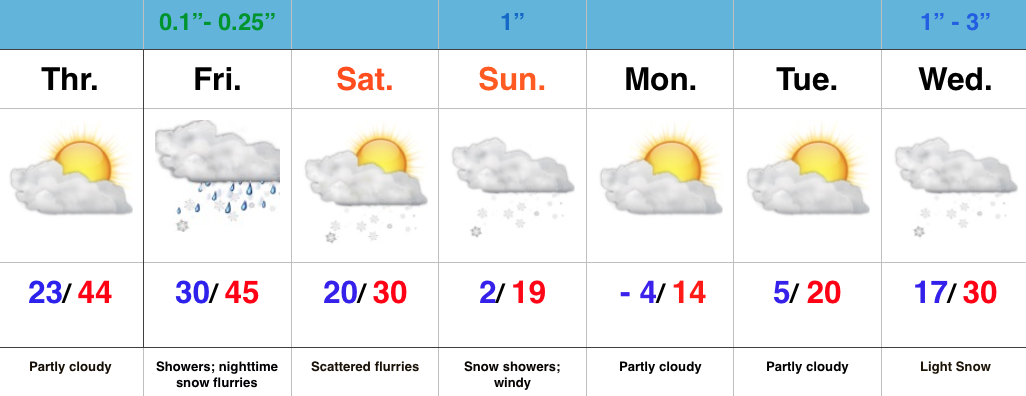
Enjoy Today; New Polar Plunge Coming…While we wait on the next severe blast of cold air, enough SW air flow will help boost temperatures to above normal levels today and Friday. We’ll introduce a few showers into the Friday forecast, so today is the “pick of the week!” Find a way to enjoy it!
What at one time looked like a significant storm system Friday into Saturday is now anything but. A very weak area of low pressure will provide showers Friday before transitioning to snow flurries as precipitation ends. Precipitation amounts will be light with this system.
Colder air begins to return tomorrow night and Saturday, but it’s Saturday night and Sunday that the next arctic invasion will get underway. By now you know the deal- we’ll also contend with snow showers and embedded heavier squalls, along with very gusty winds.
A frigid opening to next week will take place before we eye our next snow maker the middle of next week.
Permanent link to this article: https://indywx.com/2016/01/14/thaw-will-be-brief-arctic-hammer-set-to-drop/
Jan 10
Active Winter Pattern…
- Arctic air takes control
- Snow bursts overnight Monday-Tuesday
- Late week winter storm brewing?
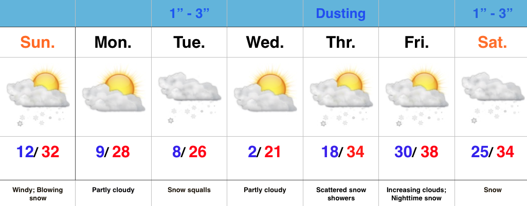
Bitter Feel; Gearing Up For More Snow…Saturday night’s storm system “split” into two and took one swath of snow across far NW IN while a second (more widespread) area of snow was laid down across central IN. Reports into the forecast office this morning indicate 2″-3″ are common across central IN, with a couple 4″ reports. Thank you for all of the snow reports and photos!
While the snow has stopped, we’ll deal with bitterly cold air and blowing snow the rest of the day. Bundle up and take it slow as you venture out. Temperatures will continue to fall into the teens and wind chill values will fall into the single digits to around zero.
Dry and cold conditions will be with us as we open the new work week, but our next weather maker will blow into town late Monday night and Tuesday morning. We still think intense snow bursts will accompany arctic reinforcements that will send temperatures below zero for some Wednesday morning. It won’t take a lot of moisture to “fluff up” 1″-3″ Tuesday morning. Couple that with gusty winds and falling temperatures and things will likely be messy on area roadways.
Looking ahead, a weak weather system will skirt the area to our north Thursday and could offer up a scattered snow shower, but it’s as we look towards next weekend that things become “more interesting.” Model specifics disagree at this time, but the overall pattern is one that’s conducive to lead to a fairly widespread interior winter storm threat. We’ll have to sort through the details as we go through the week. Stay tuned.
Permanent link to this article: https://indywx.com/2016/01/10/active-winter-pattern/
Jan 09
Hope You Like Winter…
- Rain changes to snow
- Much colder and windy
- Quick-hitting intense snow squalls
- Arctic air
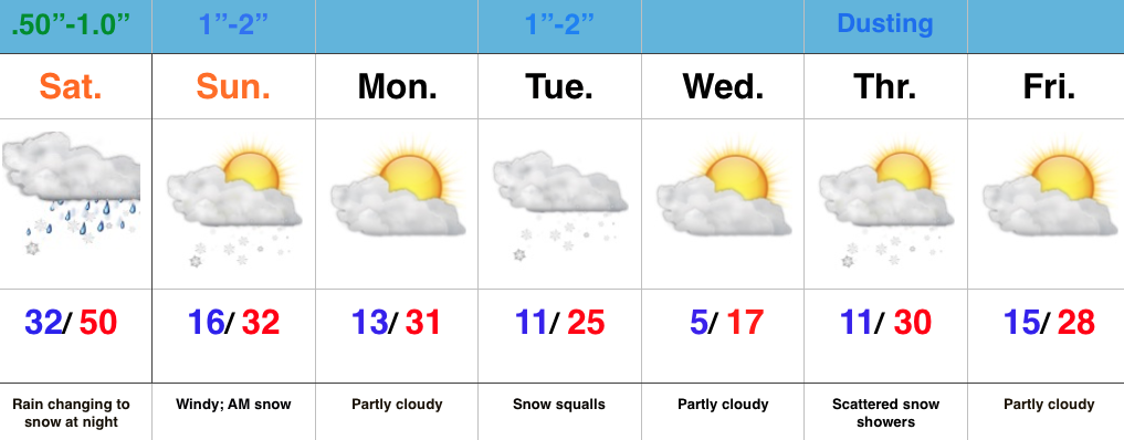
Rain To Snow Late Tonight…Most of today will be mild, but big changes will take place tonight as cold air whips around an area of low pressure that will deliver rain, especially the second half of the day. With the colder air moving in, rain will change to snow overnight and stick in spots. Timing the changeover is key in obviously determining snow amounts, but after looking over morning data, we feel as good as we can about our initial snowfall map issued last night. Additional fine tuning may be required later today, and bust potential remains high.
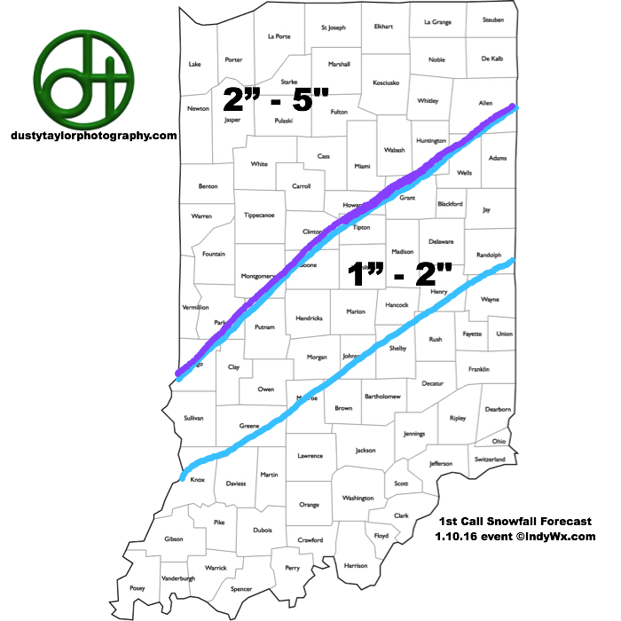 The second half of the weekend will feature morning snow along with strong and gusty north winds. It’ll be a harshly colder day (don’t let that high around freezing fool you, as that will take place around midnight).
Monday will dawn very cold, but dry, but the quiet times will be brief. Clouds will increase late day and snow will develop Monday night into Tuesday morning. Embedded heavy, quick-hitting, snow squalls will accompany arctic reinforcements Tuesday morning and set up a messy morning commute.
A third snow maker is possible Thursday and then our attention turns to next weekend for additional wintry “fun and games.” Get the idea now that we’re in a drastically different pattern when compared to December?
Permanent link to this article: https://indywx.com/2016/01/09/hope-you-like-winter/
Jan 08
Busy Times; Winter To Make A Come Back…
- Wet close to the week
- Rain to snow Saturday night into early Sunday
- One-two punch of arctic air
- Snow squalls Tuesday
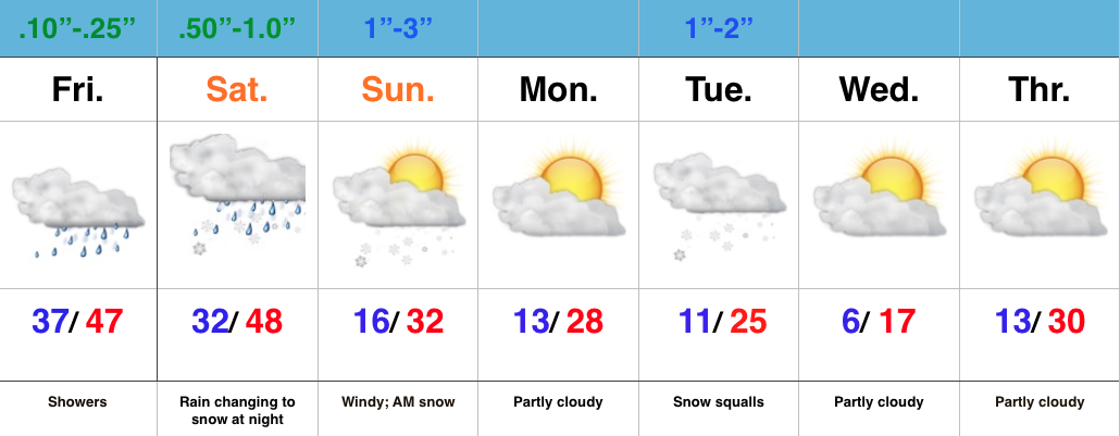
Wet Close To The Week; Winter Blows In To Town…The region will deal with two storm systems as we go through the next few days. Today’s area of low pressure will be responsible for pushing rain showers through the state and while it won’t rain the entire day, it’ll be wise to keep the rain gear nearby.
A secondary area of low pressure will lift northeast Saturday into Saturday night. Heavier rains will arrive into central IN Saturday afternoon and the precise track of this second area of low pressure is key in determining the transition from rain to snow as cold air arrives on the scene. As of now, we’ll focus on a changeover overnight Saturday night/ Sunday morning. Initial thinking paints a 1″-3″ swath across central IN, but before issuing our first snowfall map, we want to have an opportunity to see the complete 12z model suite.
Regardless of how much snow falls Sunday morning, expect a much colder feel and strong and gusty winds as we go through the second half of the weekend. Arctic reinforcements arrive Tuesday and we’ll know it. Expect snow squalls and bitterly cold air for mid week.
Looking ahead, busy times continue down the road. An early look at next weekend shows a pattern plenty capable for renewed wintry “fun and games…”
Permanent link to this article: https://indywx.com/2016/01/08/busy-times-winter-to-make-a-come-back/
Jan 05
Confidence Increasing On Leader-Follower Event; But Details Murky…
A look over model data from overnight suggests we need to focus on a “leader-follower” event for the upcoming weekend.
We’re confident the “leader” player is a rain maker for IN in the Thursday afternoon-Friday time frame (.40-.70 rainfall potential).
As we progress into the second half of the weekend, details get quite murky on the specifics with the secondary (follower) area of low pressure that develops along a pressing arctic front.
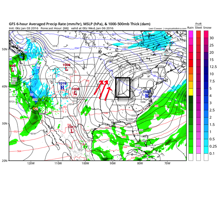
As we’ve been discussing, model solutions will vary within each respected model (GFS, Euro, GEM, etc.) in a run-to-run fashion. Stack them up against one another, and we’ll likely continue to have as many different solutions as we do models that we’re looking at. It’s a byproduct of a pattern transition and that crashing SOI (which is still crashing this morning, btw). Case in point, note the various options below for Sunday.

The Canadian is a blend of the GFS and European as it tracks low pressure from eastern LA into the central Appalachians. Source: Tropicaltidbits.com

The European is most aggressive in the west track as it takes low pressure from the MO bootheel into northern IN. Source: Tropicaltidbits.com
Past experience with similar patterns certainly leads us to lean more towards the European/ Canadian solution over the GFS from this distance. We know that models have their own biases though. Time and time again the GFS bias is to rush things along a bit too much from this distance and become too progressive. On the flip side, the European is notorious for dragging it’s heels a bit and, at times, can be too slow with bringing energy out of the west. This in return impacts things downstream…
From this distance, we still can’t be too specific with snow/ precipitation prospects Sunday. While confidence is increasing on at least some sort of snow to contend with, the significance of such isn’t possible to iron out at the moment. Much fine tuning will be required. Stay tuned.
Permanent link to this article: https://indywx.com/2016/01/05/confidence-increasing-on-leader-follower-event-but-details-murky/
Jan 03
Snow Showers Arrive Tonight…
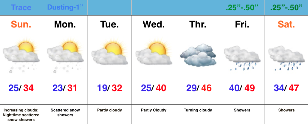
- Increasing clouds; snow showers tonight
- Calmer mid week
- Next storm delivers rain late week
- Significant cold outbreak looms
Cold Shot On Deck; Snow Showers To Develop…Our Sunday is dawning with sunshine across central IN, but we note a low cloud deck sinking south and this will engulf all of the region by afternoon. Snow showers will begin to fall across the area by tonight and continue into Monday, and this is showing up well on our high resolution forecast radar, courtesy of Weatherbell.com.
 We note the best chances of snow showers will favor the eastern half of the state as lake moisture gets involved. Speaking of that, accumulations of a dusting to an inch will be possible across east-central IN with higher amounts north in the snow belt (3-6″ amounts with a Lake Effect Snow Advisory in effect). You may want to leave extra travel time for your Monday morning commute.
Our mid week stretch will be dominated by a quiet couple of days as high pressure shifts east and we get into a return (milder) SW flow.
Our next storm system approaches late week and will result in increasing cloudiness and showers developing by Friday, continuing into Saturday.
All eyes will then remain locked in on the 11th-13th time frame for potential wintry “mischief.” There remain many more questions than answers concerning winter storm potential, but confidence continues to increase on a very cold blast of air around, or just before, mid month. Stay tuned!
Permanent link to this article: https://indywx.com/2016/01/03/snow-showers-arrive-tonight/
Jan 02
Cold, But Much Needed Sunshine…
- Much needed vitamin D
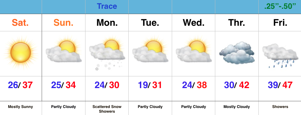
- Arctic air and scattered snow showers to open the week
- Late week storm system
- Big cold looms
Bright, But Chilly…High pressure will remain in control of our weekend weather. Though it’ll be chilly, it’s great to see the sun shining (it does still exist, after all :-))!
We’ll be on the outskirts of an arctic intrusion Monday afternoon-Tuesday morning. The brunt of the arctic air (single digits) will flow into the Northeast. That said, we’ll also note a cold open to the week. Scattered snow showers will accompany the reinforcing cold, as forecast radar below shows- courtesy of weatherbell.com.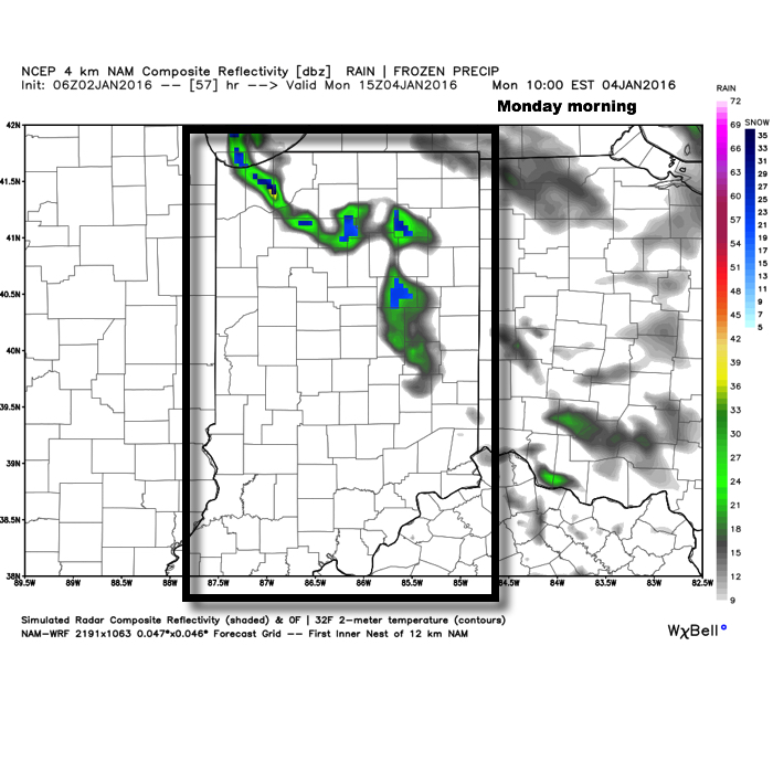
We’ll “relax” things a bit for mid week before we gear back up for a potentially active regime late week. We’ll include showers in our forecast wrapping up the work week Friday. You can read more here about our thoughts on next weekend. Bottom line, it’s a low confidence forecast at this point.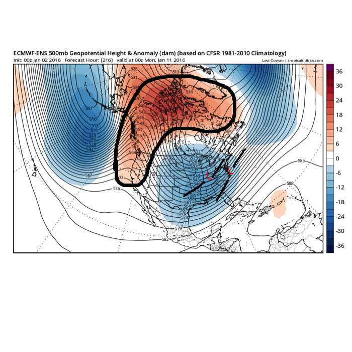
Permanent link to this article: https://indywx.com/2016/01/02/cold-but-much-needed-sunshine/
Dec 28
Strong Winds; More Heavy Rain…
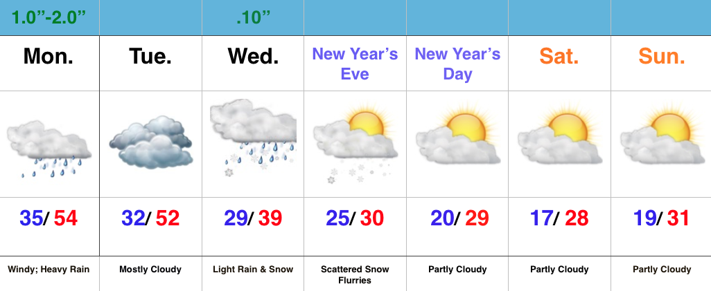
- Strong winds and flood threat continues
- Weak mid week system
- Much colder to open the New Year
Strong Winds And Flood Threat Remains…What an active morning across central IN! Northeast winds are already gusting around 40 MPH with periods of heavy rain this morning. Across our northern tier of counties (mainly north of a line from LAF to KOK) freezing rain and sleet is the issue this morning with temperatures below freezing.
Periods of heavy rain will continue today, and we also note the threat of embedded thunder (damaging wind risk) this evening, bracketed between the hours of 6p-8p.
Image below is courtesy of Weatherbell.com
 Temperatures will remain cold and raw through most of the day before we see a late day rally briefly into the lower to middle 50s. It’ll be another day with a tight temperature gradient across the state, as northern IN will struggle to make it much above freezing, while southern IN approaches the upper 60s this evening.
Midnight highs Tuesday can be expected before temperatures crash.
We’ll then set our eyes towards a weak wave of low pressure that looks to deliver a light mixed bag of precipitation Wednesday morning. The freezing line will run through the central part of IN and a mixture of light snow and light rain can be expected. MUCH colder air flows into the state behind this system and sets the stage for a cold open to 2016.
Image below is courtesy of Weatherbell.com
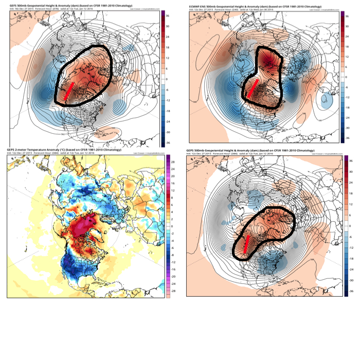
 Forecast models continue to show an expected pattern shift to all-out sustained cold and wintry conditions for mid and late winter. Note the W NA ridging developing. Additionally, blocking and a negative AO develop as mid January nears. Think this is the year without a winter? Better think again, my friends.
Image below is courtesy of Tropicaltidbits.com
Permanent link to this article: https://indywx.com/2015/12/28/strong-winds-more-heavy-rain/
Dec 25
Flooding Concerns…
- Periods of heavy rain
- Tight temperature gradient
- Much colder to open 2016
Very Wet Period Before We Turn Colder…We hope you had a blessed Christmas full of joy, peace, and laughter!
It was a beautiful Christmas across the region, complete with temperatures reaching the 50 degree mark for the first time since 1987! Many would prefer cold and snow (yours truly included), but we couldn’t ask for better weather to get out and enjoy those new gifts from Santa! The countdown to Christmas 2016 begins now. 🙂
The weather will once again turn quite active around these parts as we head into the extended Christmas weekend. Waves of heavy rain will push north Saturday and grow heavy Saturday evening. Periodically heavy rain will continue Sunday. Flooding concerns are present as event rain totals of 3″-5″ should be widespread, with locally heavier amounts.
The other big weather item to note will be the tight temperature gradient from north to south Saturday evening. Note the modeled temperature forecast Saturday night, including temperatures ranging from the lower 40s north to the upper 60s south. Heads up for central IN communities, the cold air will win out Sunday as temperatures fall through the day after an early morning high.
Image below is courtesy of Weatherbell.com
 Another push of heavy rain will surge into IN Monday as low pressure tracks northeast into the Great Lakes region. A secondary area of low pressure will form along the Mid Atlantic coast Monday and provide interior portions of the NE an icy/ snowy combo to open the new work week.
Image below is courtesy of Tropicaltidbits.com
 Things will (FINALLY) begin to dry out and chill down as we rumble closer to closing 2015 and welcoming 2016. Though forecast models aren’t seeing much in the way of precipitation with the surge of cold air, don’t be surprised if we deal with scattered snow showers during the Thursday-Friday period as upper energy teams up with the arctic surge.
All-in-all, it’s a step in the right direction for establishing the winter pattern that we think lies ahead, but we caution with a positive AO, things are likely to still be transient over the first 7-10 days of January. Once to mid month, we still believe a sustained shift to colder, more wintry times loom.
Image below is courtesy of Tropicaltidbits.com
Permanent link to this article: https://indywx.com/2015/12/25/flooding-concerns/

