July 2023 archive

VIDEO: Breath Of Fresh Air To Open The Weekend; Heat Builds For A Time Next Week, Discussing Staying Power…

Updated 07.21.23 @ 7:26a

You must be logged in to view this content. Click Here to become a member of IndyWX.com for full access.  Already a member of IndyWx.com All-Access?  Log-in here.

Permanent link to this article: https://indywx.com/2023/07/21/video-breath-of-fresh-air-to-open-the-weekend-heat-builds-for-a-time-next-week-discussing-staying-power/

Severe Storms This Evening With Large Hail Potential; Gorgeous Close To The Work Week…

Updated 07.20.23 @ 8:07a

You must be logged in to view this content. Click Here to become a member of IndyWX.com for full access.  Already a member of IndyWx.com All-Access?  Log-in here.

Permanent link to this article: https://indywx.com/2023/07/20/severe-storms-this-evening-with-large-hail-potential-gorgeous-close-to-the-work-week/

VIDEO: Beautiful Day Ahead Of Another Round Of Severe Storms Thursday Evening…

Updated 07.19.23 @ 8:45a

You must be logged in to view this content. Click Here to become a member of IndyWX.com for full access.  Already a member of IndyWx.com All-Access?  Log-in here.

Permanent link to this article: https://indywx.com/2023/07/19/video-beautiful-day-ahead-of-another-round-of-severe-storms-thursday-evening/

VIDEO: Brief Window To Catch Our Breath Before Active Times Return…

Updated 07.18.23 @ 7:27a

You must be logged in to view this content. Click Here to become a member of IndyWX.com for full access.  Already a member of IndyWx.com All-Access?  Log-in here.

Permanent link to this article: https://indywx.com/2023/07/18/video-brief-window-to-catch-our-breath-before-active-times-return/

VIDEO: Another Stormy Afternoon/ Evening Before Drier Air Builds In; Timing Out Additional Storm Chances Later In The Week…

Updated 07.17.23 @ 7:35a

You must be logged in to view this content. Click Here to become a member of IndyWX.com for full access.  Already a member of IndyWx.com All-Access?  Log-in here.

Permanent link to this article: https://indywx.com/2023/07/17/video-another-stormy-afternoon-evening-before-drier-air-builds-in-timing-out-additional-storm-chances-later-in-the-week/

Sunday Morning Rambles: Another Round Of Strong Storms And Lack Of Significant Heat Grab Headlines…

Updated 07.16.23 @ 7:44a

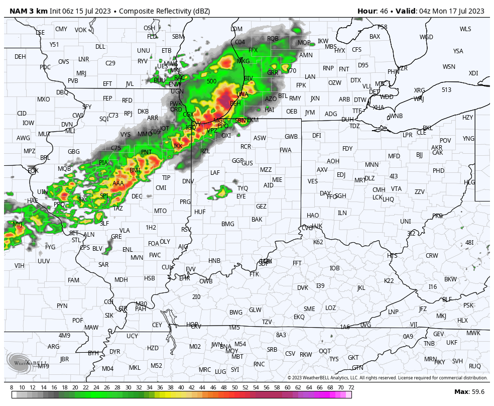
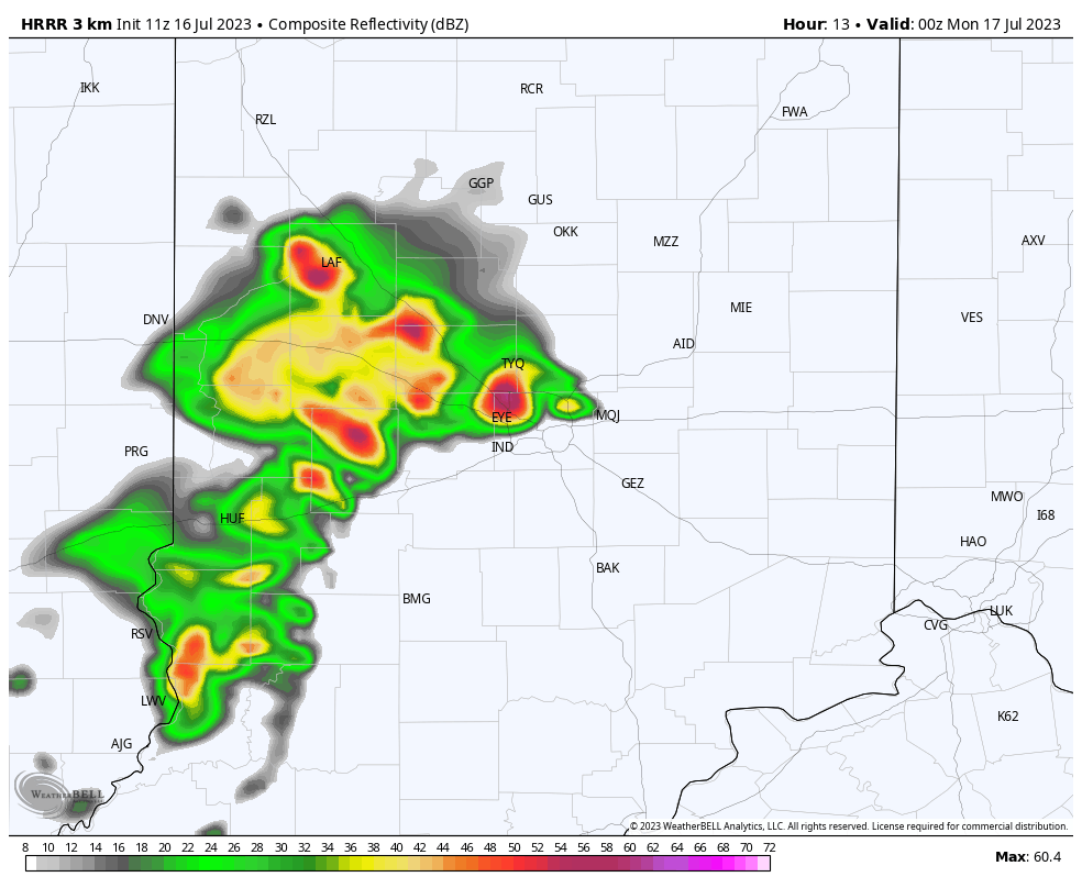
I. More of that good ole Canadian wild fire smoke is making for a hazy start to our day but thankfully all else is quiet. Unfortunately that won’t remain the case as we progress into the afternoon and evening hours. We’ll watch for darkening skies towards the mid to late afternoon and some potent storms will likely fire up by evening. A couple of these could pulse to severe levels and include a damaging wind and hail threat.

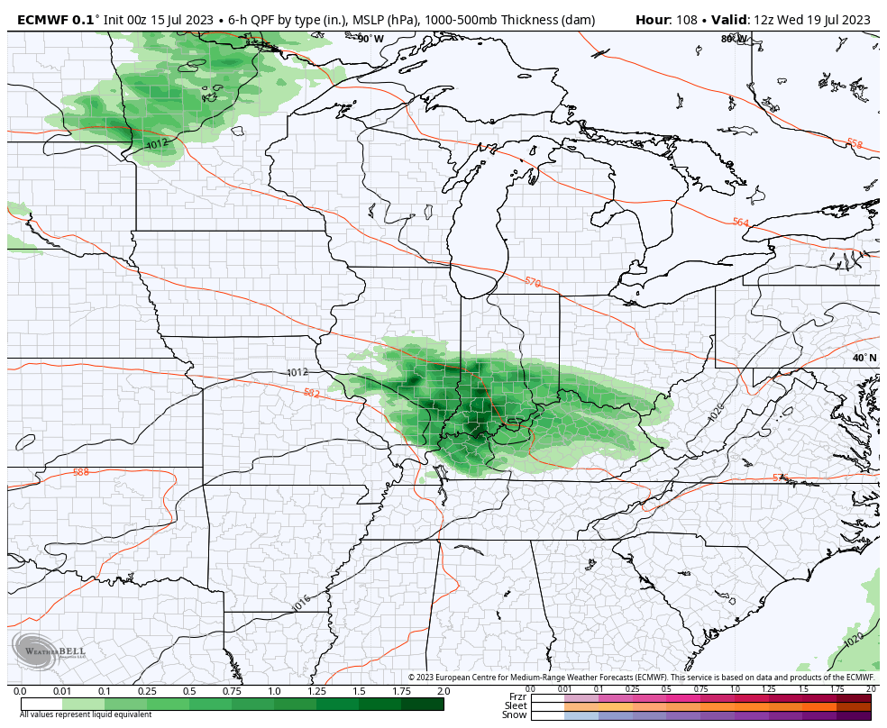
II. A cold front will take aim on the region from the northwest as we kick off the new work week. Additional scattered showers and thunderstorms will develop ahead of this boundary Monday afternoon and evening. Like this evening, a few of the storms will likely turn strong to severe (damaging wind and large hail the greatest concerns with the stronger cells).

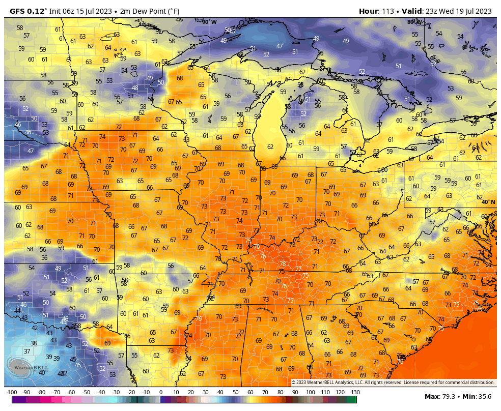
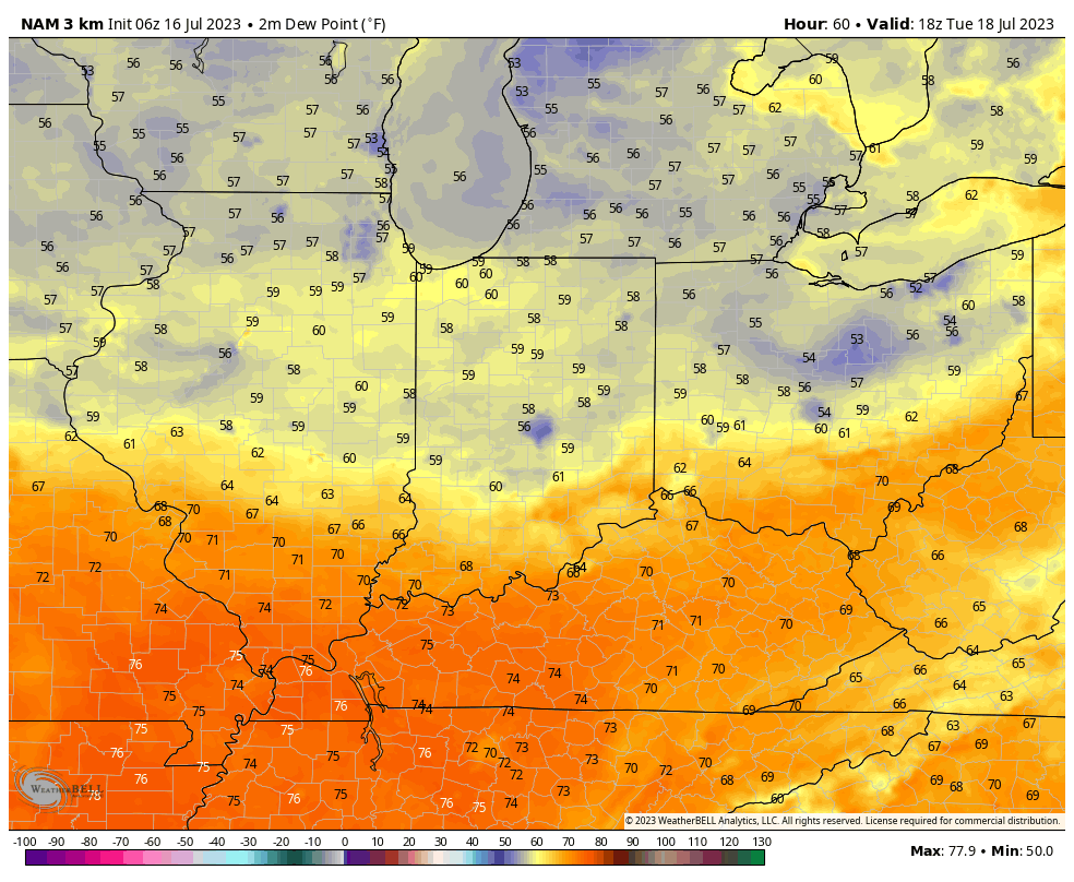
III. The cold front will push south of our region Tuesday morning before stalling along the Ohio River. Rain and storm chances should shift downstate Tuesday as a drier brand of air takes hold for the northern half of the state. Dew points into the 50s are always nice in July, heh?!

IV. A secondary front will blow through the state as we wrap up the work week and help to reinforce the unseasonably refreshing airmass going into next weekend. Lows will likely even dip into the 50s at night.

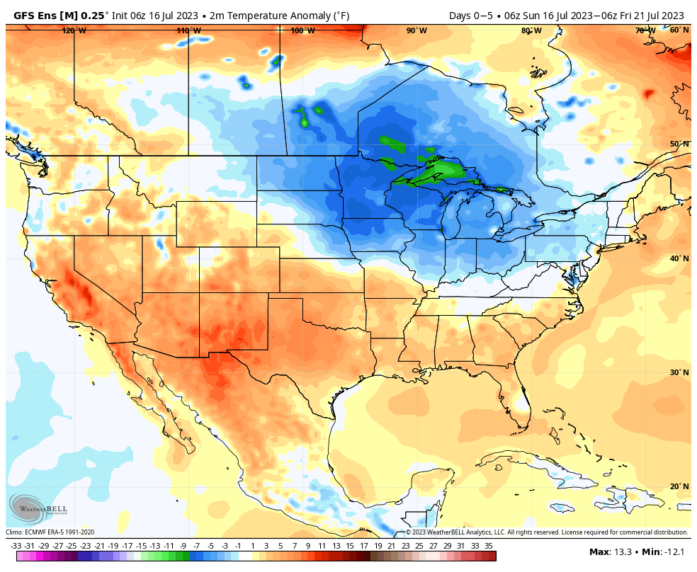
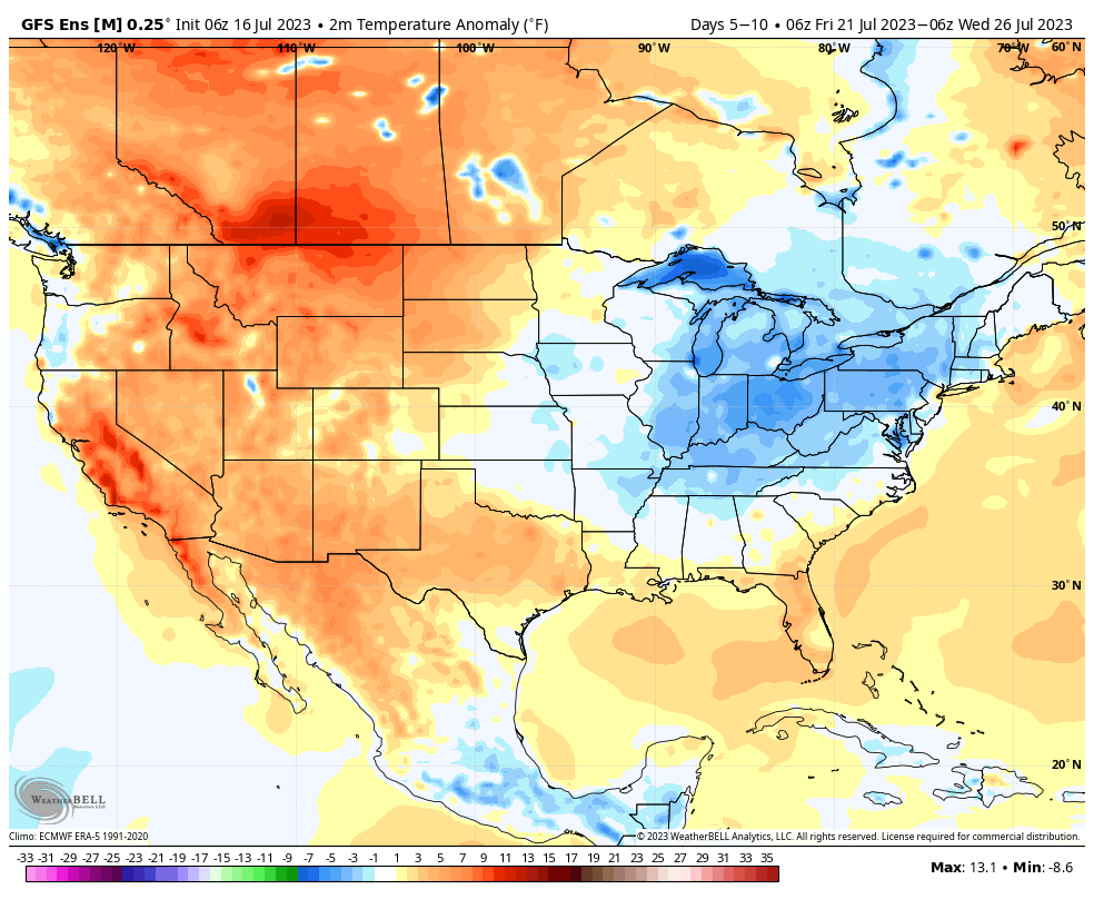
That brings us to our closing point and that’s the lack of any sort of significant heat. In fact, it’s just the opposite over the next couple weeks. The general thinking is the cooler than normal regime will likely make up the bulk of August as well, especially if we can sneak into Phase 5-6 of the MJO.

Day 1-5 temperature anomalies
Days 5-10 temperature anomalies

Permanent link to this article: https://indywx.com/2023/07/16/sunday-morning-rambles-another-round-of-strong-storms-and-lack-of-significant-heat-grab-headlines/

Wet Morning; Additional Storm Chances Ahead…

Updated 07.15.23 @ 7:34a

Heavy rain fell overnight across northern ‘burbs and now a general rain is falling across central Indiana with some embedded thunder. This will continue for the next few hours before a bit of a break in the action.

We’ll then watch for some brightening of the sky and this should be just enough to allow a few stronger storms to fire up this afternoon into the evening hours. Coverage of these storms should be greatest for central and south/ eastern parts of the state.

Most of our Sunday should feature quiet weather conditions but our attention will need to shift to the northwest by Sunday evening. Higher resolution models are seeing a storm cluster initiating in the upper Midwest before potentially dropping into central Indiana late Sunday evening into the overnight hours. It’s a tricky setup but we’ll watch for consistency over the next couple models runs and update accordingly.

Beyond this period, most of the upcoming work week will feature a general drier brand of air blowing into the state. We’ll notice lower dew points and downright comfy conditions by late July standards early week (then as you’ll see below for late week).

The exception to the drier brand of air will be in the middle of the work week when dew points briefly return to the tropical 70° range and likely fuel resurgent storm coverage.

As of now, the early call on the latter part of next week is that lower humidity and reduced rain chances will help us kick off a pleasant stretch for the weekend. 🤞🏻

Permanent link to this article: https://indywx.com/2023/07/15/wet-morning-additional-storm-chances-ahead/

Different Flavors Of El Niños And Impacts On The Winter…

Updated 07.14.23 @ 10:34a

After a rare triple dip La Niña, significant changes have taken place in the equatorial Pacific this past spring and summer. The question isn’t “if” we’re dealing with an El Niño this fall and winter, but rather what type, or “flavor” of Nino we get to enjoy.

(A quick piece of advice for anyone viewing winter outlooks that are being published ridiculously early: be skeptical to any sources “broad-brushing” the outlook by labeling it simply as an “El Nino winter”).

Like we say with every seasonal outlook it seems, each Nina, Nino, or even neutral events have their own characteristics. No single event is identical. While we can gain valuable insights that can help build the foundation of what lies ahead through looking back at the past, undoubtedly, every year will have a few surprises. It’s our job to try and limit those surprises the best we can. 😉

A look at the current sea surface temperature (SST) configuration shows the warmest anomalies tucked in to Nino 3 and Nino 1+2.

Simply put, if this look continues this fall and into the early winter, it’s a warm to very warm signal for winter, locally.

The million dollar question is how the early stages of this Nino evolves in the coming weeks and next few months. There’s reason to believe there’s a chance this transitions into more of a central based, or “Modoki” El Niño event by winter. If that’s the case, we’ll have to up the ante for colder, more wintry conditions.

(You can read more about Modoki El Niño events here).

While still a bit early to put too much stock in any of the seasonal products for winter, it is interesting to see how the latest European seasonal model is trending as we move into the Nov through Jan timeframe below.

Stay tuned. We’ll really begin to firm up preliminary meteorological winter (Dec through Feb) thoughts over the course of the next couple months.

Permanent link to this article: https://indywx.com/2023/07/14/different-flavors-of-el-ninos-and-impacts-on-the-winter/

VIDEO: Storm Chances Ramp Up Saturday; Looking Into The Pattern Evolution Into Mid-Late August…

Updated 07.14.23 @ 6:15a

You must be logged in to view this content. Click Here to become a member of IndyWX.com for full access.  Already a member of IndyWx.com All-Access?  Log-in here.

Permanent link to this article: https://indywx.com/2023/07/14/video-storm-chances-ramp-up-saturday-looking-into-the-pattern-evolution-into-mid-late-august/

“Log Jam” Of A Pattern Over The Next Couple Of Weeks…

Updated 07.13.23 @ 8:16a

You must be logged in to view this content. Click Here to become a member of IndyWX.com for full access.  Already a member of IndyWx.com All-Access?  Log-in here.

Permanent link to this article: https://indywx.com/2023/07/13/log-jam-of-a-pattern-over-the-next-couple-of-weeks/

IndyWx.com