May 2020 archive

Long Range Update: Heat Comes In Spurts, But Still A Long Way Off From Sustained Warmth…

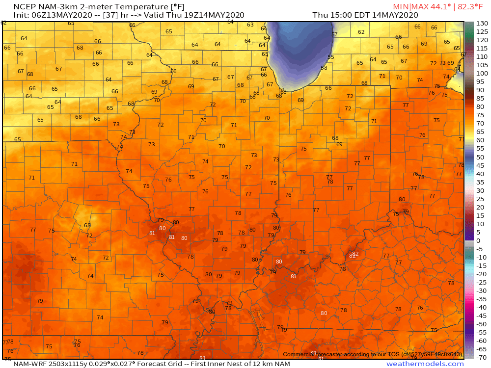
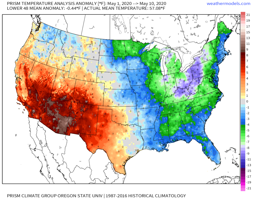
After a chilly May featuring all-time record cold to begin the month, the flip to warmer air has been welcome by many over the past 24 hours. This warmer regime will continue into the weekend before getting beaten back next week. This is due to a closed off upper level low that will actually manufacture it’s on chill across the Ohio Valley, Mid-Atlantic, and Southeast during this time frame.

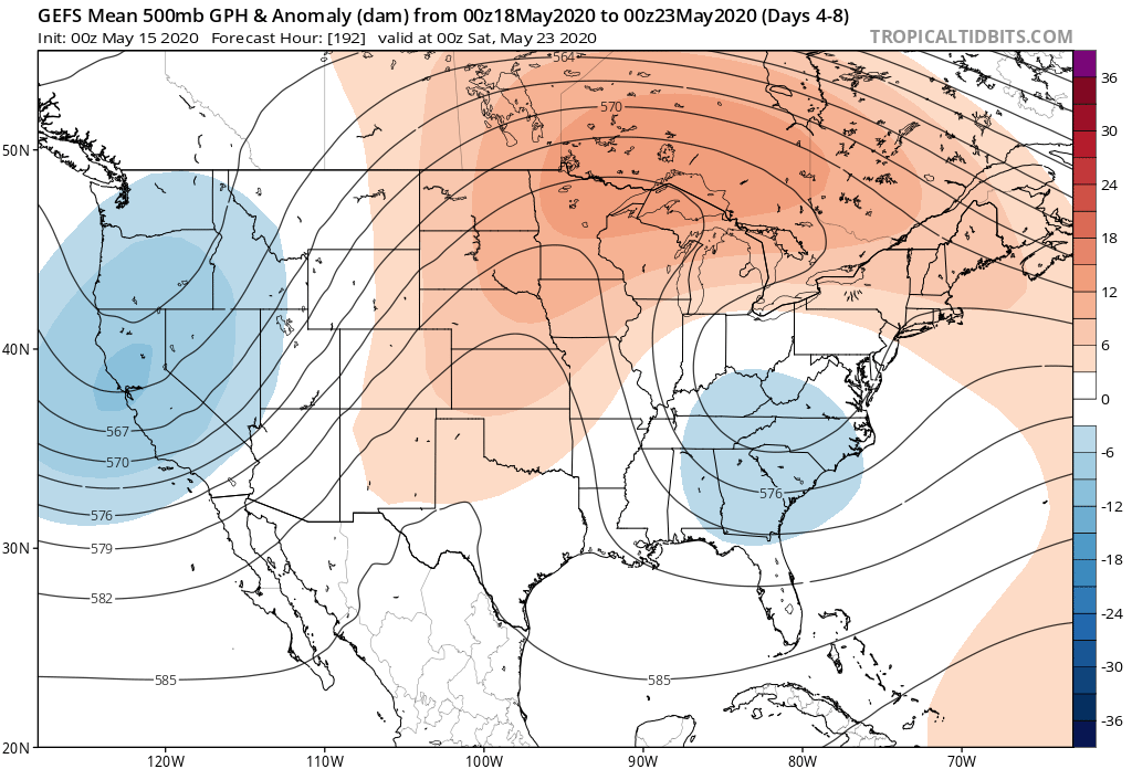
Sometimes it can be like pulling teeth to get these kind of features to leave and models can struggle (case in point, this upper low was originally modeled to be located over Nova Scotia- NOT the Southeast and Mid-Atlantic)!

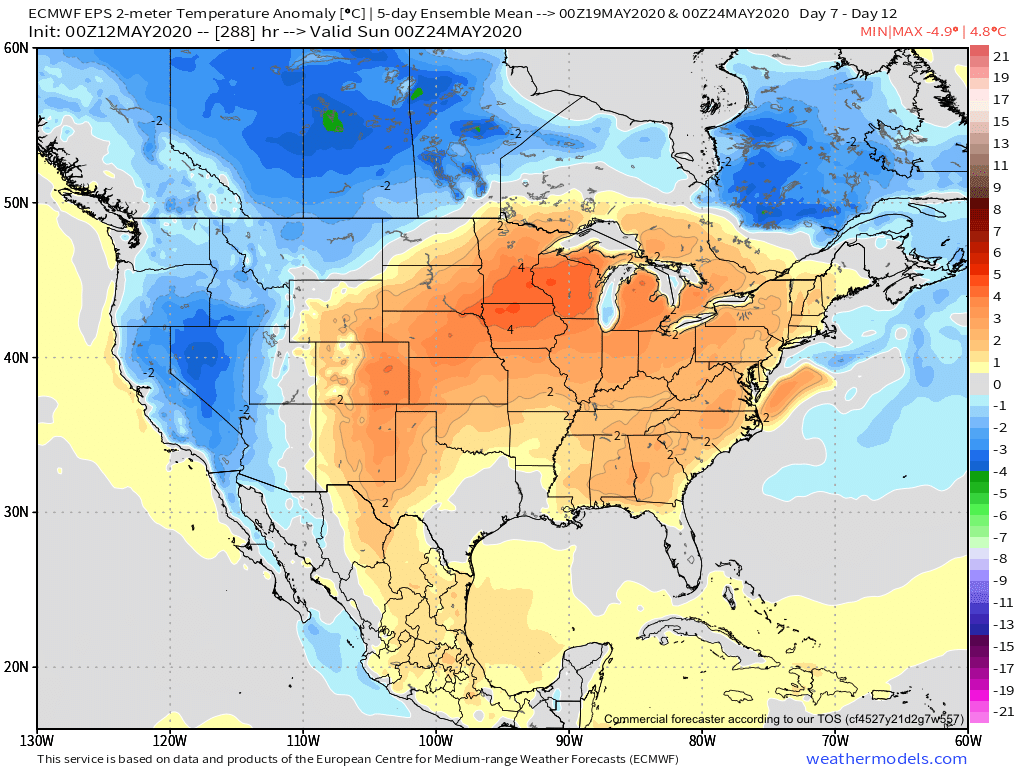
Nevertheless, we believe the one time expected surge of heat next week will only be a scenario of “delayed, not denied.” By the time we head into Memorial Day weekend, we continue to believe legitimate summer warmth will move in (85°-90° stuff).

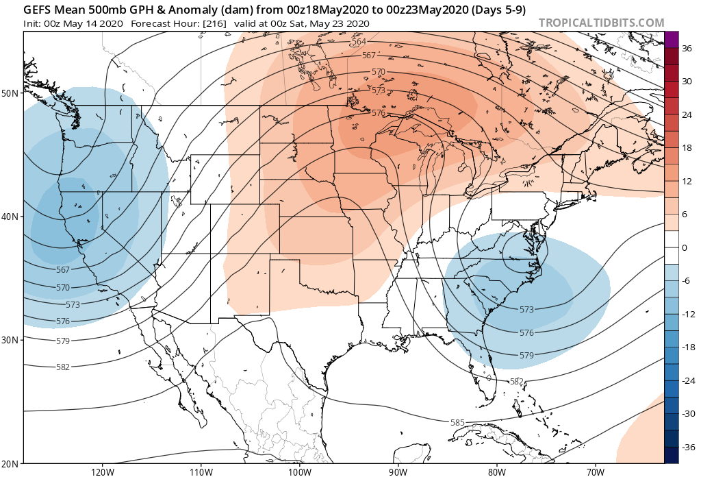
The new CFSv2 agrees with the European ensembles above.

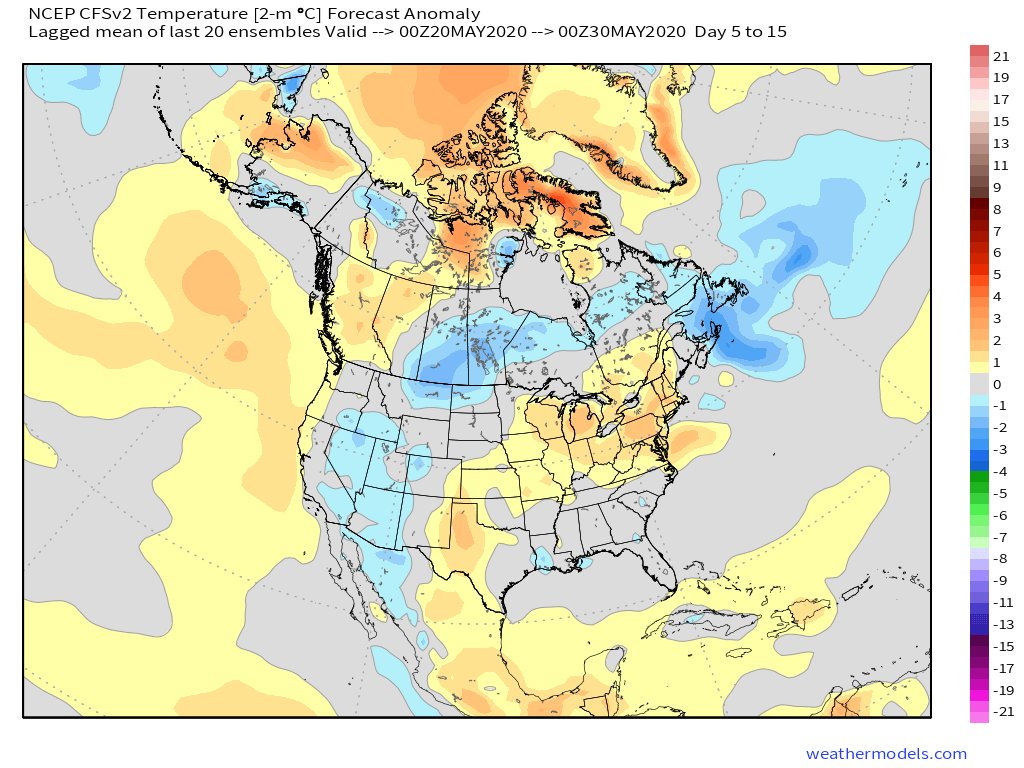
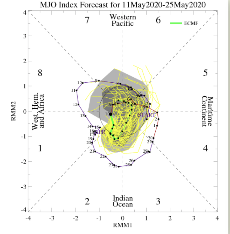
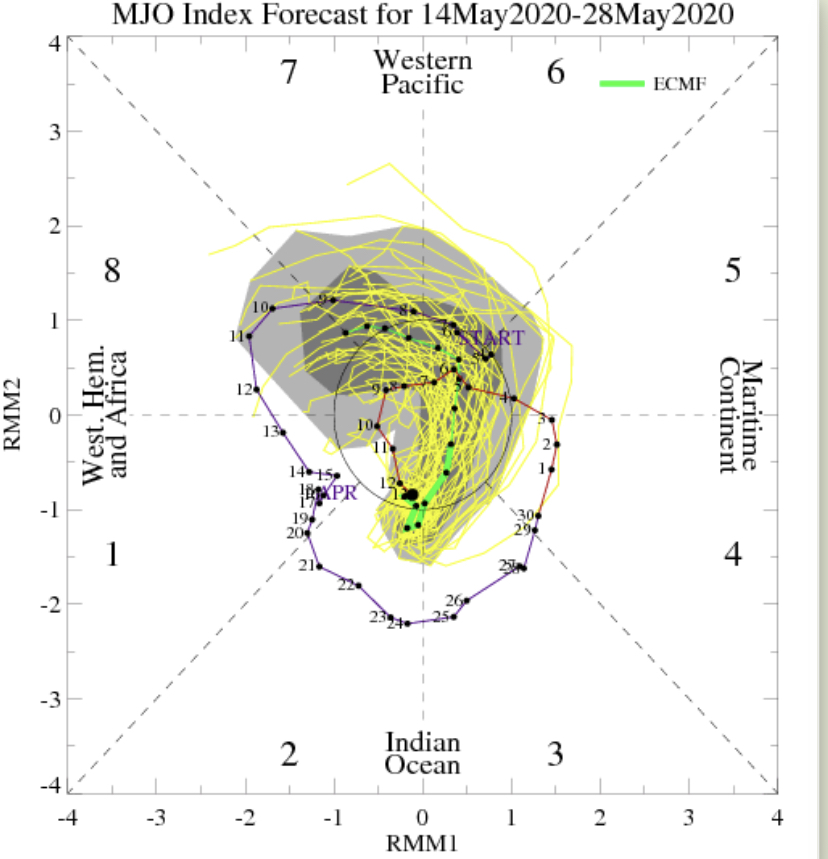
Longer range (last few days of May and early June) will depend heavily on what goes on with a combo of the MJO and EPO/ PNA. 2 of 3 of these signals argue for cooler air to return during that time period.

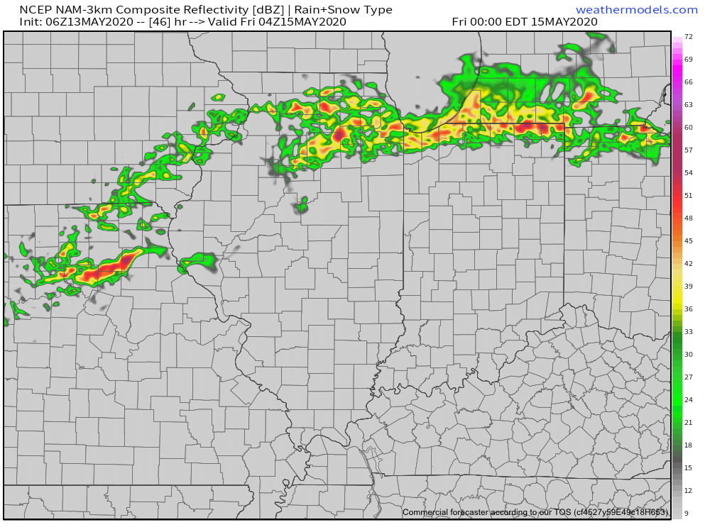
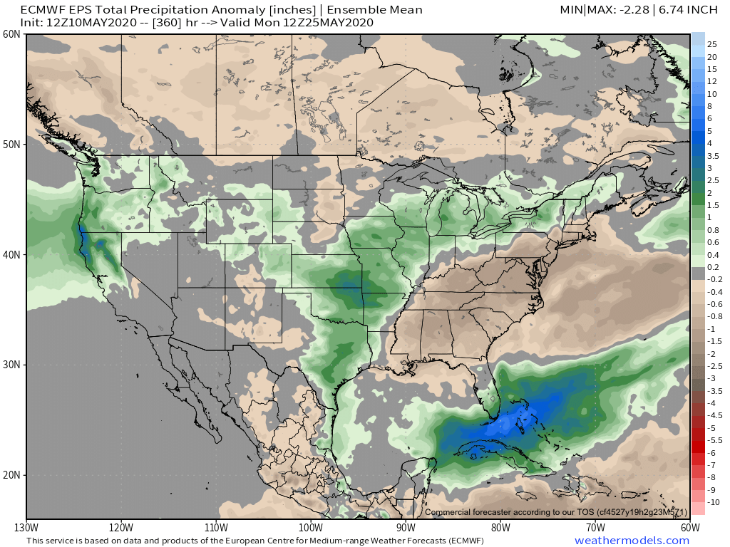
We shall see how it plays out, but our official lean is towards the cooler side of things after the Memorial Day heat. From a precipitation perspective, after the short-term wet period, overall dry conditions are set to return as we wrap up May.

Permanent link to this article: https://indywx.com/2020/05/15/long-range-update-heat-comes-in-spurts-but-still-a-long-way-off-from-sustained-warmth/

Thursday Morning Rambles: Storms Accompany Warmth; Interesting “Twist” To The Longer Range…

I. After a cold and dry open to May, (Month-to-date, Indianapolis is running 8.4° below avg. and 1.24” below normal in the precipitation department) changes have arrived.

II. A warm front will lift north through the state today and deliver those warmer changes. The transition from cool to more of an early summer feel will be met with a couple rounds of storms today. Some of those storms will be strong to severe (damaging winds being the greatest concern), especially north of the city. Strongest storms should arrive across the northern half of the state during the early to mid afternoon hours.

III. A “half-n-half” weekend is expected. After a wet Friday, drier air is expected to arrive to help us out Saturday. Showers and storms will return Sunday courtesy of a cold front and associated surface low. Locally heavy rainfall will be possible Friday & Sunday and when you add in what falls today, most of the state from the city and points north can expect widespread 2”-2.5” with locally heavier amounts.

IV. An area of low pressure and upper level trough is now shown to “cut off” over the Mid-Atlantic region in the medium range period. This is forecast to dramatically cool the Monday through Thursday time frame (instead of 80s, we’re now talking upper 50s, 60s and low 70s during the period). This is worth keeping an eye on as models can struggle handling these kind of features, but as it stands now, after a brief encounter with warmth this weekend, it doesn’t appear as if we’ll get back to the heat until Memorial Day weekend.

Permanent link to this article: https://indywx.com/2020/05/14/thursday-morning-rambles-storms-accompany-warmth-interesting-twist-to-the-longer-range/

Off To The Races; Warmth Met With Periodic Storms…

A band of light showers is falling across southern Indiana this morning, but these are expected to diminish before pushing into central Indiana. Most of the remainder of our Wednesday should be rain-free.

The quiet times will give way to a couple of rounds of storms during the overnight and into Friday. Most notably for central Indiana, we think storm chances will increase significantly after midnight and through the predawn hours Thursday. Locally heavy rain and vivid lightning is expected with the stronger storms.

These storms are in association with a warm front lifting north through the state. Speaking of warm, we’ll certainly notice a difference in air masses between today (still relatively cool and dry) and tomorrow (much warmer and more humid). In fact, highs Thursday will flirt with 80° across most of central Indiana.


Once we get rid of the early morning storms, most of the remainder of our Thursday will be dry and feature a return of the sun.

Another round of storms is expected Thursday night into Friday, but most of these will remain well north of our area. A few of these could become severe across northwestern Indiana during this period.

Rain and storm chances will increase once again during the day Friday across central Indiana. A few strong storms will be possible.

As we look ahead to the weekend, it appears we’ll be able to enjoy a mostly dry day Saturday (widely scattered storm possible) before more widespread storms return Sunday. Warm and humid conditions will prevail. A cold front will move through the area early next week which will allow for briefly cooler, drier air to move in during the 1st half of next week. Before that takes place, rainfall amounts between tonight and Sunday are expected to range from 1.5” – 2” with locally heavier totals across central Indiana. Heavier rainfall amounts can be expected across northern Indiana (widespread 3” to 4” amounts during the same period).

Permanent link to this article: https://indywx.com/2020/05/13/off-to-the-races-warmth-met-with-periodic-storms/

Major Flip On Deck; Discussing Longevity…

Indianapolis is running a whopping 8° below normal month-to-date. We’ve set new daily and all-time records already this month for the cold. Note the vast nature of this May chill.

If you’re not a fan of the late season chill, hang in there, as a major flip in the pattern awaits. We alluded to this possibility in our May Outlook and it continues to look like a rather abrupt change is a couple of days away. While we’re dealing with frost this morning in spots across east-central Indiana, it’s looking more and more likely that the first true summer-like surge of air for the season arrives Thursday into the weekend. Warmth will be accompanied by a significant uptick in humidity levels.

The Week 2 period looks warmest, relative to average, and should feature at least a couple of days with highs approaching the 85°-90° mark.

While most data maintains a warmer pattern to close the month, there are a couple of items to pay close attention to as we try and understand the longevity of said warmth.

  1. The MJO is forecast to remain “bottled up” in the wheelhouse through the next couple of weeks. Thereafter, there are indications that the MJO might become more amplified and it’ll be important to keep an eye on what phase(s) it’ll move through as we get set to close May/ open June.

2. The PNA is forecast to take a negative dip which supports the coming flip to warm. However, recent ensemble data is bullish on a move towards a positive (some data shows even strongly so) state around or just after Memorial Day. This would suggest the window of warmth may be limited in duration. Simply based on looking at the chart below, one could build a case for a cool open to meteorological summer.

Finally, on the precipitation front, a wetter pattern is anticipated to accompany the warm change, but longer range data points towards this being only a temporary wetter regime. In fact, recent models are beginning to agree on a dry close to May/ open to June.

Much more later!

Permanent link to this article: https://indywx.com/2020/05/12/major-flip-on-deck-discussing-longevity/

From One Extreme To The Other…

The work week will get off to the same unusually chilly start we’ve begun to grow accustomed to. Additional frost and freeze threats are present Tuesday and Wednesday mornings if skies can clear (big if there). However, significant changes loom as we flip the page to the second half of the work week and longer term indications suggest we’re well on our way to a true summer-like feel by week 2.

Note how bullish the European ensemble is regarding the significant pattern flip over the next couple weeks.

A lot of this is driven by a change in the EPO. This is the kind of pattern that stands to at least threaten sending high temperatures soaring to between 85°-90° between Week 2 and month’s end. Talk about a contrast from the late winter and early spring-like chill to open the month!

The transition in the pattern is likely to be met with a much more active storm track through the area beginning midweek. There will be a threat of locally heavy rain and stronger storms that will continue at times into the weekend and beyond into next week, as well.

For a month that’s gotten off to a dry start, we’ll likely recover quickly with this wetter regime that accompanies the flip to warm.

We continue to believe most central Indiana neighborhoods will see between 1.75”-2.25” late week into the weekend, but there will be locally heavier amounts. The majority of data also suggests a corridor of wetter than normal conditions sets up from the Plains into the northern Ohio Valley/ Great Lakes into Week 2.

Stay tuned.

Permanent link to this article: https://indywx.com/2020/05/11/from-one-extreme-to-the-other/

Weekly #AGwx And #Severe Outlook…

Weekly Highlights:

I. Additional threat of late season frost/ freeze early in the forecast period.

II. Transition in the pattern midweek signals a significant flip from the record chill across the East to one much more typical for mid-late May. Meanwhile, the West will turn much cooler.

A transition in our overall weather pattern will lead to a return of wet weather mid-late week, including multiple rounds of t-storms from the Plains into the Ohio Valley.
7-day rainfall should run between 1.75″ and 2.25″ with locally heavier amounts across central Indiana.
While the period will run cooler than normal, it’s because the first few days this week will run so far below normal. We’ll actually warm significantly mid-late week, however, the deviation from normal won’t be enough to tip the scale from the week being cooler overall across the Plains and East.
A couple gusty storms are possible across central and eastern IN this afternoon. We’ll also have to closely monitor late week for the threat of additional strong thunderstorms.

Forecast Period: 05.10.20 through 05.17.20

An area of low pressure and associated cold front will blast across the Ohio Valley during the next 24 hours. Ahead of the front, scattered showers are already entering the state from the west this morning. As we progress into the afternoon, we’ll watch for the potential of a couple skinny lines of thunderstorms try to develop across central and eastern parts of the state. A couple of these storms could quickly pulse to strong – severe levels and pose a threat of damaging straight line winds and hail. Once the front scoots to our east, we’ll notice a much colder (yet again) northwesterly breeze and drier conditions to open the work week. There will be a threat of another frost and freeze by Tuesday morning. Patchy frost is also possible Wednesday morning, especially across east-central parts of the state.

Thereafter, our region will undergo a rather significant flip in the overall pattern. As a result, an airmass much more typical of mid-May will engulf the eastern portion of the country. With the significantly warmer conditions will also come a few rounds of rain and thunder during the mid-late week stretch. Locally heavy rain is likely towards the end of the period including the threat of additional strong thunderstorms in the Thursday-Saturday time frame.

Permanent link to this article: https://indywx.com/2020/05/10/weekly-agwx-and-severe-outlook-6/

VIDEO: New Daily And May All-Time Record Low Established; Looking Ahead To The Upcoming Week…

You must be logged in to view this content. Click Here to become a member of IndyWX.com for full access.  Already a member of IndyWx.com All-Access?  Log-in here.

Permanent link to this article: https://indywx.com/2020/05/09/video-new-daily-and-may-all-time-record-low-established-looking-ahead-to-the-upcoming-week/

VIDEO: Stage Set For Record Cold Saturday AM; Updated Long Range Thoughts Towards Memorial Day Weekend…

You must be logged in to view this content. Click Here to become a member of IndyWX.com for full access.  Already a member of IndyWx.com All-Access?  Log-in here.

Permanent link to this article: https://indywx.com/2020/05/08/video-stage-set-for-record-cold-saturday-am-updated-long-range-thoughts-towards-memorial-day-weekend/

In Position To Challenge The All-Time Record Low For May Saturday; Discussing Degree Of Moderation Late Month…

We may only be a few weeks away from meteorological summer, but you wouldn’t know it. Instead, we’re talking about the potential of wet snow mixing in with a cold rain to close the work week and threat of lows falling into the 20s Saturday morning!

A strong cold front will settle south across the Ohio Valley Friday morning. In response to the front moving south, surface low pressure will organize along the boundary across the TN Valley Friday morning before roaring northeast and off the New England coast Saturday morning.

Widespread light rain will overspread the southern half of the state during the wee morning hours Friday, continuing into the mid to late morning before pushing off to the east. This will be a cold rain and may even mix with wet snowflakes at times before ending.

This won’t be a huge precipitation producer across central Indiana with most checking in between 0.10″ and 0.25″ (heavier amounts expected across southern Indiana).

Temperatures will slowly fall through the 40s during the daytime Friday. (Yes, we’re talking about May 8th)!

That then sets us up to at least be in position to break the all-time record low for the month of May (28° set in 1966). This will be an airmass with arctic origins and if high pressure can clear us out in time Friday night, overnight lows by Saturday morning are likely to fall into the upper 20s. High resolution guidance takes IND to between 26° and 27° while the European data remains consistent at 28°. Regardless, this will be “rare air” for so late in the season. Those with ag interests should use today to prepare for a hard freeze Friday night into Saturday morning.

Looking ahead, the bulk of the upcoming 7-day period will remain much cooler than average, but there are at least hints of a potential pattern change during the 8-10 day period. The European data is much warmer than the GEFS or new JMA Weeklies that are in-house. Additionally, the teleconnections don’t scream an all-out pattern change. Regardless, a period of moderation would certainly be welcome after this unusually chilly spell. We’ll have much more on this later today with our long range video update. Stay tuned.

Permanent link to this article: https://indywx.com/2020/05/07/in-position-to-challenge-the-all-time-record-low-for-may-saturday-discussing-degree-of-moderation-late-month/

VIDEO: Record Territory; Looking Ahead To Late May…

You must be logged in to view this content. Click Here to become a member of IndyWX.com for full access.  Already a member of IndyWx.com All-Access?  Log-in here.

Permanent link to this article: https://indywx.com/2020/05/06/video-record-territory-looking-ahead-to-late-may/

IndyWx.com