
You must be logged in to view this content. Click Here to become a member of IndyWX.com for full access. Already a member of IndyWx.com All-Access? Log-in here.
May 2020 archive
Permanent link to this article: https://indywx.com/video-cut-off-upper-low-and-late-may-thoughts/
May 17
VIDEO: Discussing The Severe/ Localized Flooding Threat Tonight And Looking Ahead To The Holiday Weekend…
You must be logged in to view this content. Click Here to become a member of IndyWX.com for full access. Already a member of IndyWx.com All-Access? Log-in here.
Permanent link to this article: https://indywx.com/video-discussing-the-severe-localized-flooding-threat-tonight-and-looking-ahead-to-the-holiday-weekend/
May 17
Risk Of Rotating Storms This Evening-Tonight…
Quick short-term update this morning to discuss the potential of severe weather later this evening and into the nighttime hours. (We’ll have a more in-depth video update posted this evening, including longer range thoughts).
This morning has featured a few rain showers scattered about central Indiana, but the heavier, more organized, rain from the overnight is long gone (for now). While showers will impact central Indiana at times into the early afternoon hours, it’s not until late evening and the nighttime hours that we anticipate more organized shower and thunderstorm activity. Given the ingredients in place, there’s the potential of a few rotating storms tonight and subsequent risk of tornadoes. Sunshine, or not, it’ll be important to remain weather-aware tonight and have a means of getting the latest warnings that may be issued. Should we see a period of sunshine later this afternoon, the threat of severe weather will be elevated tonight.
The Storm Prediction Center (SPC) includes central and western portions of the state in a Slight Risk of severe weather in their most recent Day 1 Outlook.

The window of severe weather potential appears to come after 8p for central Indiana, continuing into the overnight hours.

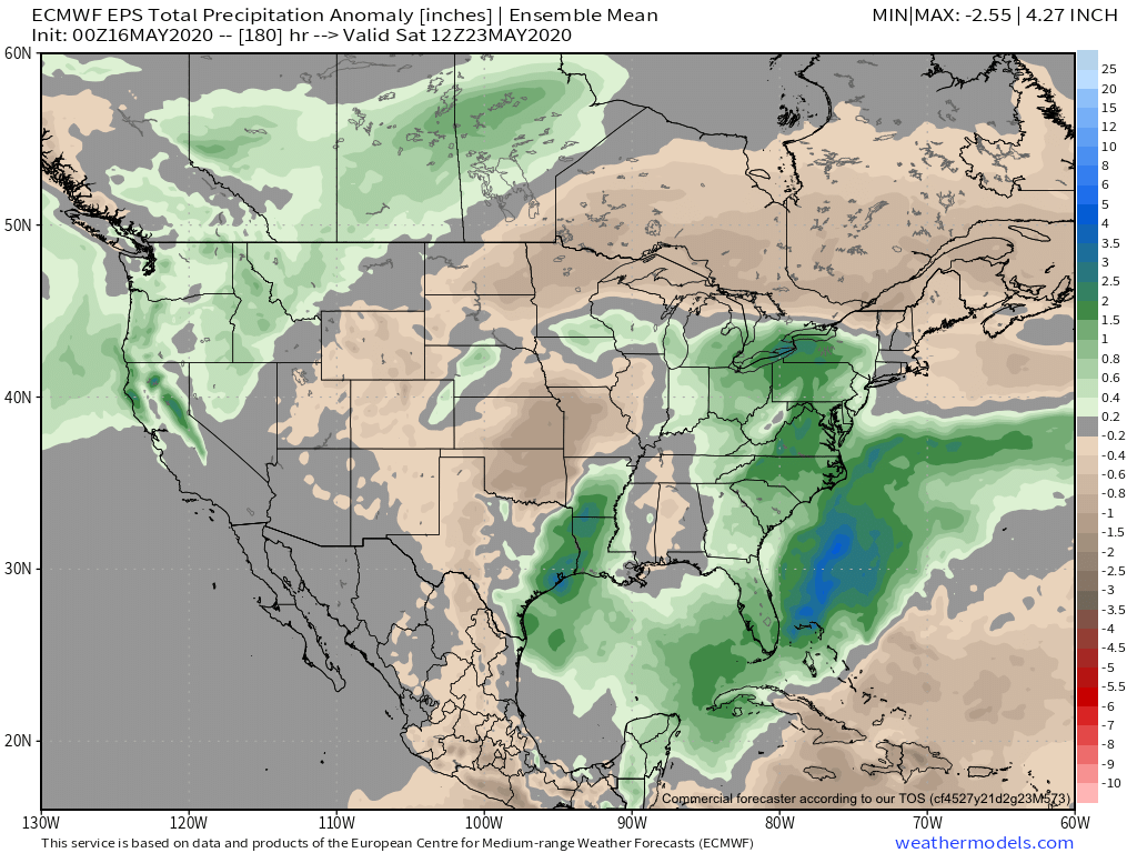
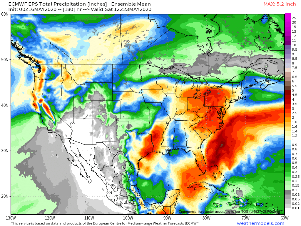
Locally heavy rain will shift from western Indiana (tonight) into the eastern half of the state (Monday). Widespread 1″ to 2″ of additional rain is likely.

As the upper low “cuts off” early-mid week, shower chances will continue along with cooler temperatures.
Make it a great Sunday! Chat with y’all a bit later today!
Permanent link to this article: https://indywx.com/risk-of-rotating-storms-this-evening-tonight/
May 16
VIDEO: Gorgeous Saturday; Storms Return Tonight And Looking Ahead Towards Memorial Day Weekend…
You must be logged in to view this content. Click Here to become a member of IndyWX.com for full access. Already a member of IndyWx.com All-Access? Log-in here.
Permanent link to this article: https://indywx.com/video-gorgeous-saturday-storms-return-tonight-and-looking-ahead-towards-memorial-day-weekend/
May 16
Weekly #AGwx And #Severe Outlook…
Weekly Highlights:
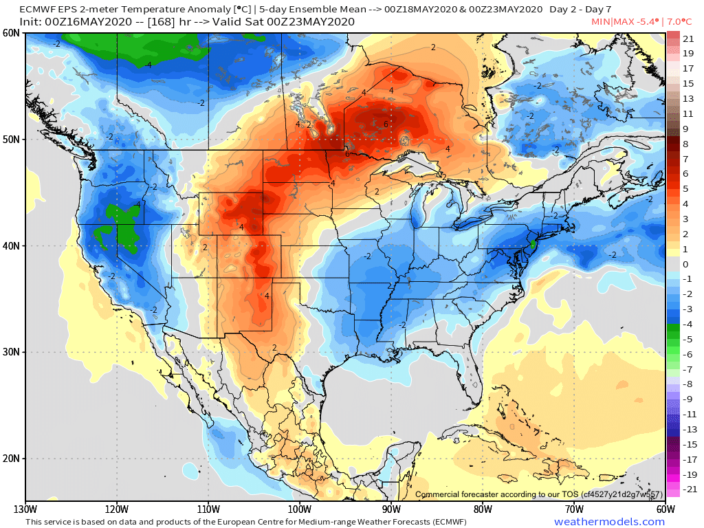
I. Cut off upper low will keep things cool and unsettled for much of the upcoming week across the East.
II. Summer-like heat is poised to expand across a good chunk of the area around and just after Memorial Day weekend.

Forecast Period: 05.16.20 through 05.23.20
Most of our Saturday will feature beautiful weather to spend time outdoors. In fact, we’re not expecting a drop of rain across central Indiana through the daytime. Add in highs around 80° and a gorgeous day is in the making! Get out and enjoy it!
Weather conditions will begin to go downhill tonight and Sunday as periods of showers and thunderstorms develop. Locally heavy rain is expected. This is all thanks to an area of low pressure and associated cold front that will help pull in a much cooler airmass as we progress through early week. After the heavy rain threat tonight into Sunday, the showers that fall early week (associated with the upper low) will be more of the nuisance variety.
That much cooler air mass will linger through a good portion of the week before an upper level ridge expands into the area around Memorial Day weekend. This will deliver a more summer-like airmass to the immediate area.
Permanent link to this article: https://indywx.com/weekly-agwx-and-severe-outlook-7/