
You must be logged in to view this content. Click Here to become a member of IndyWX.com for full access. Already a member of IndyWx.com All-Access? Log-in here.
May 2020 archive
Permanent link to this article: https://indywx.com/video-better-short-term-storm-chances-meteorological-summer-looms/
May 26
Sticky Now; Big Changes Arrive By The Weekend…
A warm and humid airmass will remain intact through the next 72 hours. Little impulses of energy scooting across the area will be all that’s needed to ignite scattered showers and thunderstorms, but not all will see rain. Due to the moisture content, those that do find themselves under a shower or storm can expect locally heavy totals. Thursday will likely offer up the best chance of more widespread thunderstorm activity.

Friday will continue to offer up scattered showers and thunderstorms courtesy of a cold front moving through the Ohio Valley. Once this front slides south, MUCH drier and cooler air will filter into central Indiana, leading to a fantastic weekend. A northeasterly flow around high pressure will create a much more refreshing feel. Lows in the 40s and highs in the upper 60s to lower 70s are a good bet this weekend.

The cooler, more refreshing air won’t stick around for more than a few days before warmth rebuilds. This is in association with the MJO moving into Phase 1 (a phase favoring widespread warmth across the Lower 48 this time of year). Drier conditions should prevail as temperatures warm early June.

An interesting item to keep tabs on has to do with the potential of tropical “mischief” in the Gulf towards mid-late month. If you have beach plans down to those beautiful Gulf Coast beaches, this is something I’d recommend keeping a close eye on over the next 2-3 weeks. Should something develop, the pattern would favor the central/ eastern Gulf it would appear from this distance.
Permanent link to this article: https://indywx.com/sticky-now-big-changes-arrive-by-the-weekend/
May 25
VIDEO: Late Week Cold Front Offers Up Changes…
You must be logged in to view this content. Click Here to become a member of IndyWX.com for full access. Already a member of IndyWx.com All-Access? Log-in here.
Permanent link to this article: https://indywx.com/video-late-week-cold-front-offers-up-changes/
May 24
VIDEO: Warm And Humid Memorial Day Weekend; Timing Out Features Into Mid-June…
You must be logged in to view this content. Click Here to become a member of IndyWX.com for full access. Already a member of IndyWx.com All-Access? Log-in here.
Permanent link to this article: https://indywx.com/video-warm-and-humid-memorial-day-weekend-timing-out-features-into-mid-june/
May 24
Weekly #AGwx And #Severe Outlook…
Weekly Highlights:
I. Summer-like pattern arrives for most just in time for the unofficial start to summer.
II. Cold front rumbles in late week with a better chance of organized storms and much cooler air for the weekend.

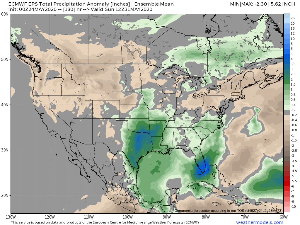
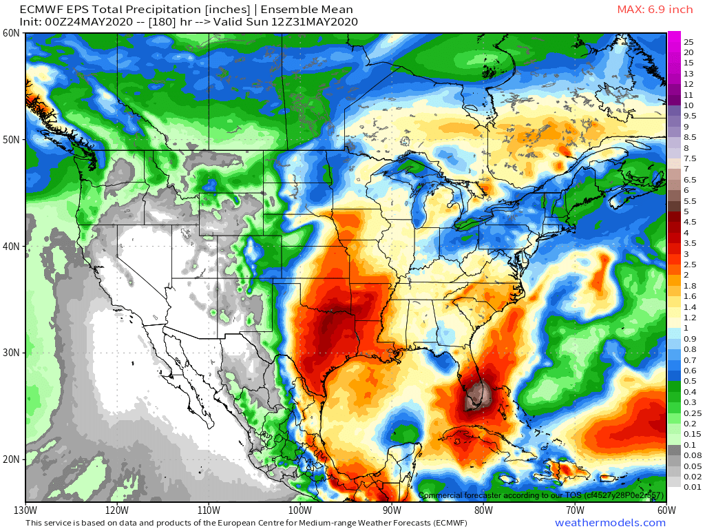
Forecast period: 05.24.20 through 05.31.20
The majority of this forecast period will feature a “rinse and repeat” forecast on a daily basis: warm to hot, humid, and daily chances of isolated to widely scattered thunder. The exception will be late week (centered on Friday) as a cold front drops in from the north. This will result in better coverage of thunderstorms along with much cooler air by next weekend (good bet lows fall into the upper 40s by next weekend). Looking ahead to early June looks to continue the “back and forth” theme as we welcome in meteorological summer.
Permanent link to this article: https://indywx.com/weekly-agwx-and-severe-outlook-8/