Type: Impactful Wintry Weather

What: Accumulating snow; mixed wintry precipitation
When: This evening into Tuesday morning
Temperatures: Lower to middle 30s, falling into the middle 20s Tuesday morning
Wind: Northeast shifting to the northwest Tuesday morning
Blowing/ Drifting: Minimal
Pavement Impacts: Plowing and salting will be required.

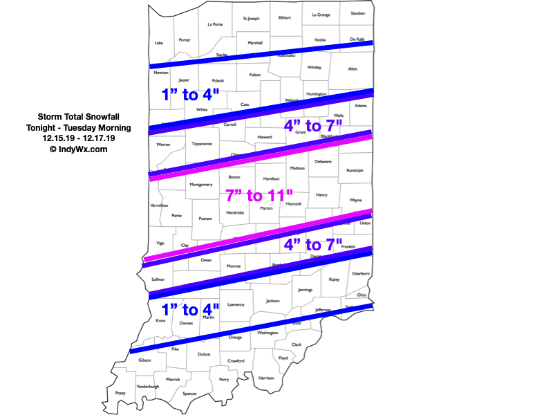
“Round 2″ is underway and we actually believe the overall snow shield will become more expansive with time through the late evening and overnight hours. Within this growing snow shield, embedded banding is expected that will include moderate to heavy snowfall rates. This continues to look like an I-70 special with respect to heaviest totals (7″ to 11″ range for storm totals). On either side of that heaviest snow zone, 4″ to 7” can be expected. On the north side, this is due to lighter intensity of snow (both with Part 1 and Part 2) and mixing issues on the south side.
Snow will exit the city just before daybreak, and southeast Indiana between 8a and 9a. Winds will shift to the northwest and an overall colder day is expected Tuesday, but at least we won’t have to worry about additional snow once past daybreak.
Cold air reinforcements will blow into town Wednesday with a couple snow showers across east-central Indiana. The bigger deal will be the cold, including temperatures that will remain stuck in the middle 20s through the daytime hours. Add in a stiff breeze and wind chill values will be in the 10s.
Confidence: High
Next Update: Tuesday morning
