April 2017 archive
-
Filed under Forecast Discussion, Forecast Models, Rain, Severe Weather, snow, Spring, T-storms, Unseasonably Cool Weather, Unseasonably Warm, Weather Rambles, Windy
-
April 3, 2017
1.) Showers moved through the region early this morning and we’ll go through several dry hours before dealing with our next round of rain and thunderstorms by evening. Most widespread coverage of showers and thunderstorms appears to come in the 5p-7p range.
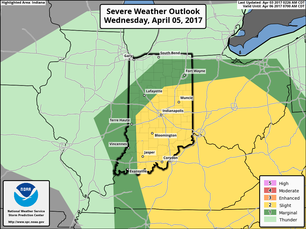
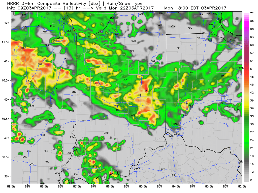 2.) We’ll get a breather on Tuesday, but our next storm system will move in quickly and begin impacting central Indiana during the day Wednesday. A couple strong to severe thunderstorms are possible Wednesday and will require our attention over the next day, or so. We’ll have more details with our updated 7-day later today.
 3.) We’ll get into the colder side of the storm to close the work week and thoughts will shift from storms to snow. Wind-whipped snow showers will be a good bet in the unseasonably cold air Thursday into Friday morning.
 4.) Timing will once again be our friend as we push into the weekend. Weak high pressure will arrive on the scene and help ensure dry conditions. After a cold start Saturday, a moderating trend will develop.
Permanent link to this article: https://indywx.com/monday-morning-rambles-3/
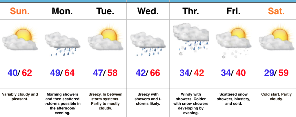 Highlights:
- Pleasant close to the weekend
- Rainy open to the work week
- Turning colder with rain and snow late week
Sunshine Gives Way To Rain…The weekend will end on a pleasant note as weak high pressure provides a variably cloudy sky today. That early-April sunshine will help temperatures top out in the lower 60s this afternoon.
Clouds will increase tonight and showers will develop during the overnight period. We’ll add a little instability to the mix by afternoon and introduce thunderstorms into the forecast Monday afternoon and evening. This storm system will then exit just as quickly as it arrives Monday night and help set up a pleasant Tuesday.
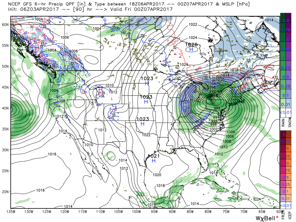
Eyes will then shift to a stronger storm system that will bring widespread showers and thunderstorms Wednesday, with locally heavy rain a good bet. As the storm wraps up over the Great Lakes region late week, colder air will spill into the state on gusty northwesterly winds. Backlash, wind-whipped, rain showers will transition to wet snow showers Thursday into Friday as colder air settles in. The good news here is that the weekend will get off to a nice start…after a cold beginning Saturday morning.
Upcoming 7-Day Precipitation Forecast:
- Snowfall: 0.00″
- Rainfall: 2.00″ 2.50″ with locally heavier totals
Permanent link to this article: https://indywx.com/active-week-of-weather-ends-wintry/
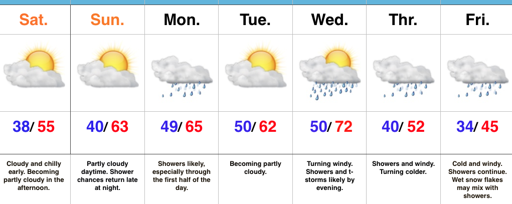 Highlights:
- Nice weekend
- Rain returns Sunday night-Monday
- Strong storm potential Wednesday PM
- Cold close to the week
Sunshine Should Make An Appearance Today…The weekend is opening chilly, including wind chills around freezing this morning. Hang in there- sunshine should at least make an appearance later on this afternoon and Sunday certainly looks to be a brighter day, overall, before clouds increase late and give way to showers overnight into Monday morning.
We’re back to sunshine Tuesday before a stronger storm begins to impact the state Wednesday. A rather robust area of low pressure will track into the Great Lakes region Wednesday night and help pull a briefly warmer, increasingly moist air mass into the area. Potential is present for strong to severe thunderstorms Wednesday evening into the nighttime. We’ll then transition to a much cooler regime to close the week and with low pressure slowly pivoting through the Ohio Valley, showers will continue Thursday into Friday. In fact, the air may grow cold enough to allow for a few wet snowflakes to mix with the rain by Friday morning.
Upcoming 7-Day Precipitation Forecast:
- Snowfall: 0.00″
- Rainfall: 1.75″ – 2.25″
Permanent link to this article: https://indywx.com/quiet-weekend-gives-way-to-an-active-work-week/
