January 2017 archive

Hold On To Your Hat; Accumulating Weekend Snow?

Screen Shot 2017-01-31 at 8.07.29 AMHighlights:

  • Windy Tuesday
  • Scattered flurries; snow showers tonight-Wednesday AM
  • Accumulating weekend snow?

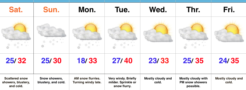
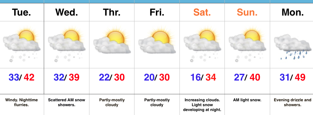
Bumpy Ride…Wind will be the big weather item today as a clipper low passes to our north.  Gusty west breezes will reach 30 MPH at times.  Otherwise, it’ll be a mild day as highs reach the lower 40s.  Cooler air will arrive tonight and will promote the chance of a passing flurry or scattered snow shower into Wednesday morning.

We’ll close the week with cold and dry conditions, including highs below freezing both Thursday and Friday.

As we move into the upcoming weekend, a storm system will attack the lingering cold air and this will allow for a period of snow to develop Saturday night into Sunday morning.  We still have time to monitor this event, but as of now this appears to be a relatively weak, flatter wave and “light” is the key word to describe the snow intensity Saturday night into Sunday morning.

Models want to drive a more significant storm system to our northwest early next week.  What’s new this winter?  A windy warm-up would result, including heavier rains late Monday into Tuesday.

Upcoming 7-Day Precipitation Forecast:

  • Snowfall: 1″ – 2″
  • Rainfall:  0.25″ – 0.50″

Permanent link to this article: https://indywx.com/2017/01/31/hold-on-to-your-hat-accumulating-weekend-snow/

Sunday Morning Rambles…

1.) Our fast-moving NW flow continues today. Snow showers and localized heavier squalls will increase later this afternoon and evening as another upper level disturbance moves through. This won’t be a “uniform” event, but if driving please plan on rapidly reduced visibilities within the heavier squalls.


2.) Overall, the upcoming week looks chilly, but relatively dry. Fast-moving disturbances can be a pain for modeling and “last minute” corrections can take place, but consistency on the next storm system tracking north of the region Monday evening and Tuesday morning continues. We’ll note a gusty wind during this time frame (30-40 MPH gusts), but don’t foresee significant precipitation across central parts of the state.


3.) There’s the chance for snow showers midweek, but our attention will shift to the prospects of a “more meaningful” event next weekend. With this being a storm we’re watching for the day 7 period, confidence is low and specifics vary greatly. Stay tuned this week as we fine tune the details. Just know from this distance, an accumulating event is possible.


4.) The last couple of weeks has featured an impressive January “thaw.” We note the blow torch regime of the past week across the central and east below.


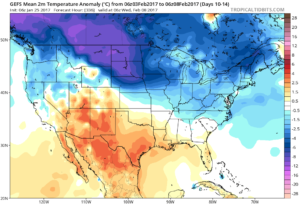
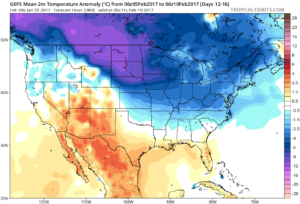
See the shift back to winter, especially across the northern tier as we close January and flip the calendar into February.


The GEFS is bullish on the cold growing stronger as we progress through the first half of February.


Permanent link to this article: https://indywx.com/2017/01/29/sunday-morning-rambles-4/

Wintry Weekend; Accumulating Snow Sunday…

Screen Shot 2017-01-27 at 4.59.51 PMHighlights:

  • Wintry weekend
  • More widespread snow Sunday
  • Reinforcing cold next week

Scattered Snow Showers Turns To Steadier Snow Sunday…Upper level energy will continue to track across the region this weekend, setting off periods of snow showers and embedded heavier squalls (case in point this evening).  The strongest upper level energy will pass Sunday evening and the result should be a period of more widespread snow Sunday- especially in the afternoon and evening.  A light accumulation (1″-2″ potential) is possible.

The new work week will begin with early flurries Monday and then we’ll kick in a strong and gusty southwest wind Monday night, continuing into Tuesday.  We’ll turn milder briefly Tuesday, but strong winds will remain.  We’ll continue to monitor the Tuesday night-Wednesday morning period as some modeling wants to deliver a round of light snow with the reinforcing chill.  We’ll give it another round of model runs, but we may need to hit snow a little harder in the Tuesday night period.

Another disturbance will race through the region Thursday with snow showers and then we’ll eye the potential of a stronger system next weekend…

Upcoming 7-Day Precipitation Forecast:

  • Snowfall: 1″ – 3″
  • Rainfall:  0.00″ 

Permanent link to this article: https://indywx.com/2017/01/27/wintry-weekend-accumulating-snow-sunday/

Snow Returns To The Forecast…

Screen Shot 2017-01-25 at 9.34.13 PMHighlights:

  • Prolonged period of scattered snow showers
  • Much colder and windy
  • Winter returns

Scattered Snow Showers; Steadier Snow Sunday?  Let’s cut right to the point:  The January “thaw” is over.  Yes, it was nice while it lasted, but we all knew it couldn’t continue (right?)!  😉

A much colder brand of air will be with us as we close the work week and head into the weekend.  Additionally, upper level energy will keep periods of snow showers in our forecast.  A more vigorous piece of upper level energy will push southeast to close the weekend and this should create more widespread snow showers.  We’ll “enjoy” a colder and blustery weekend.

As the dawn of a new work week arrives, the weather will slowly improve.  Colder than normal conditions will remain, but we’ll return to dry conditions Monday.

Our next system will pass Tuesday with gusty winds and colder air for mid week, complete with a return of snow showers.

Looking for potential of “more significant” snow?  That may loom just past the current forecast period…

Upcoming 7-Day Precipitation Forecast:

  • Snowfall:  1″ – 2″
  • Rainfall:  0.00″

Permanent link to this article: https://indywx.com/2017/01/25/snow-returns-to-the-forecast/

Wednesday Morning Weather Brief…

Your complete weekly discussion can be found in the post below from last night, but here’s a recap of our current 7-day:

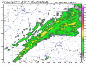
Screen Shot 2017-01-24 at 9.49.46 PMShowers will expand in overall coverage as we progress through the late morning hours, but shouldn’t amount to much (0.10″ for a few neighborhoods).  We return to a drier theme this afternoon.
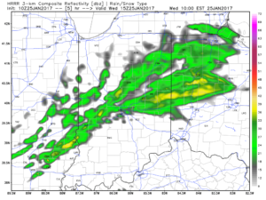
10a forecast radar

10a forecast radar

11a forecast radar

11a forecast radar

A mild and windy afternoon is ahead, including gusts close to 40 MPH and highs in the lower-middle 50s.

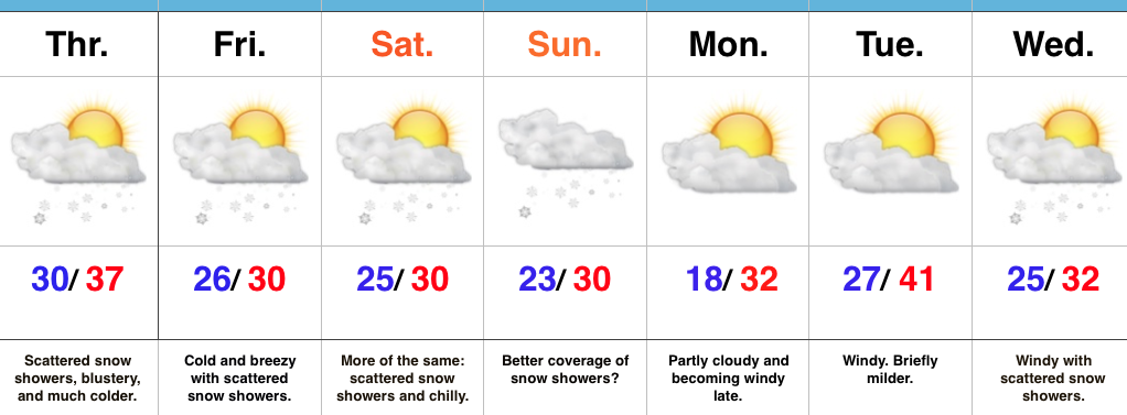
Colder air will return tonight and remain in place through the second half of the work week, including the upcoming weekend.  Temperatures will grow cold enough Thursday morning for scattered snow showers.

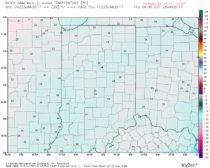
Low-mid 30s Thursday morning

Low-mid 30s Thursday morning

Upper level energy will keep scattered snow showers going late week and on into the weekend.  Models can struggle on timing and specifics of the pieces of energy and we’ll keep an eye on things into the weekend.  Potential is present for a more “robust” clipper Sunday that could yield better coverage of steady snow showers.

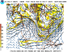
gfs_namer_106_500_vort_ht_sLonger term, the GFS ensemble continues to show the cold growing deeper and stronger for the region as we progress into early February.  Winter is far from over.
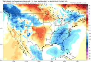
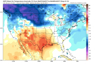
gfs-ens_T2maMean_us_5

gfs-ens_T2maMean_us_8gfs-ens_T2maMean_us_10gfs-ens_T2maMean_us_12

Permanent link to this article: https://indywx.com/2017/01/25/wednesday-morning-weather-brief/

One More Mild Day; Old Man Winter Is Knocking On The Door…

Screen Shot 2017-01-24 at 9.49.46 PMHighlights:

  • Hold on to your hats
  • Cold air returns
  • Extended period of scattered snow showers; squall potential

Changes Brewing…Wednesday will feature more of the same mild weather we’ve come to know and enjoy across the Mid West over the past couple of weeks.  Despite the mild air, a storm system will result in scattered showers for our hump day, along with very windy conditions.  Gusts of 40 MPH will be common across central IN.

Temperatures will fall late Wednesday and Old Man Winter is set to make up for lost time as we progress through the back half of the work week and on into the weekend.  In addition, fast-moving upper level energy will push southeast in the active northwest flow aloft.  Scattered snow showers will result, along with localized embedded heavier squalls.  It certainly won’t snow the entire time, but passing snow showers will be a good bet from time to time Thursday through Sunday.

Our wintry pattern will relax briefly early next week, but renewed cold air appears poised to blow into town the middle of next week.

Upcoming 7-Day Precipitation Forecast:

  • Snowfall: Dusting – 1″ (local 2″ amounts possible)
  • Rainfall: 0.10″ – 0.25″

Permanent link to this article: https://indywx.com/2017/01/24/one-more-mild-day-old-man-winter-is-knocking-on-the-door/

Winter Returns…

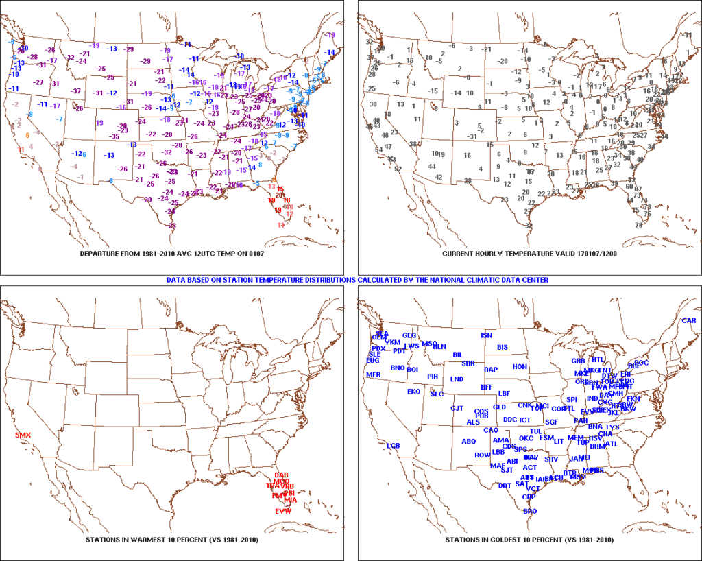
January got off to a frigid start.  Remember this coast-to-coast cold, including sub-zero temperatures across central IN, during the first week of the month?

t0-1024x818After the past week to ten days, that frigid open to the month seems like forever ago!  The past 7-10 days has featured a significant January thaw, and temperatures now, MTD, are warmer than average across the Ohio Valley.  Warmest anomalies can be found across the southeast region.
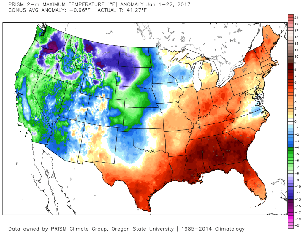
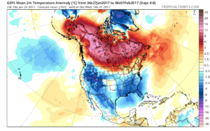
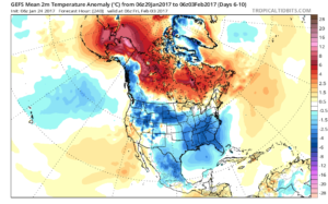
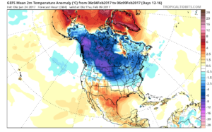
conus_mtd_t2max_anom_2017That said, the pattern is shifting back to winter for the last week of the month and while the duration, longer-term, can be argued, the next 2-3 weeks appear to offer an opportunity to play “catch up” in both the snow and cold departments.  Note the developing eastern troughiness.  This will bring colder air back into the east as we close January and open February.  The GFS ensembles, courtesy of Tropicaltidbits.com, also develops an interesting “blocky” look towards the end of the period in Week 2.  Should this verify, it would lead to a better chance of the cold, active pattern locking in.
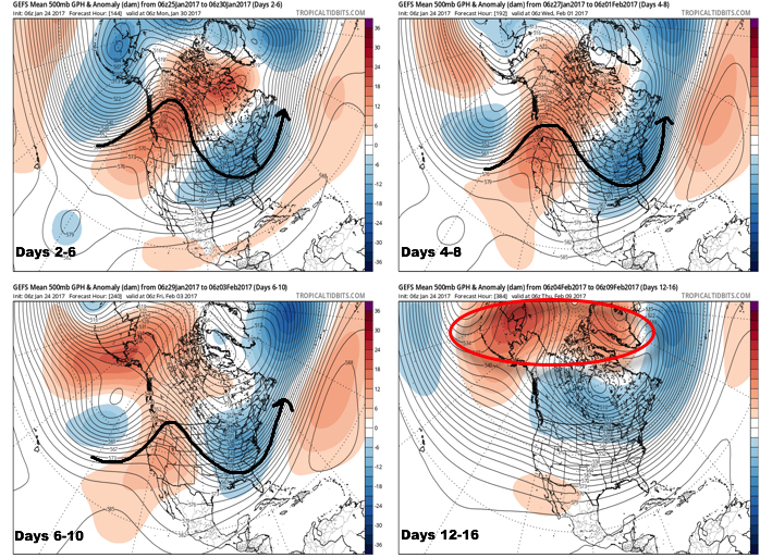
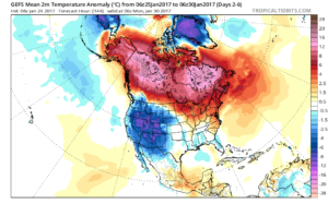
GEFS2wk12417
You’re corresponding temperature anomalies show the shift back to a colder than normal regime.

Days 2-6

Days 2-6

Days 4-8

Days 4-8

Days 6-10

Days 6-10

Days 12-16

Days 12-16

A fast northwest flow will also result in multiple “pieces” of energy rotating southeast and we’ll forecast a period of snow showers by mid and late week, continuing into the weekend.  There’s the chance of a stronger clipper system sometime in the Sunday-Tuesday time frame that we’ll have to keep a close eye on.  We want to stress that global modeling will struggle with the specifics (timing and strength) of these clipper systems until within a couple days.

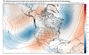
Longer term, while confidence is high on the evolution to a cold, wintry regime through the medium range, the longevity and sustainability of the cold is in question.  For instance, by Day 10 (as the GFS continues to drill cold into the region), the European ensembles are much less impressed and suggest the overall transient pattern we’ve dealt with for the balance of the winter continues:

ecmwf-ens_z500aNorm_namer_11

ecmwf-ens_T850a_namer_11Thinking here at IndyWx.com believes the European is likely rushing the warmer central look.  Time will tell…
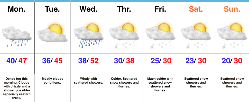
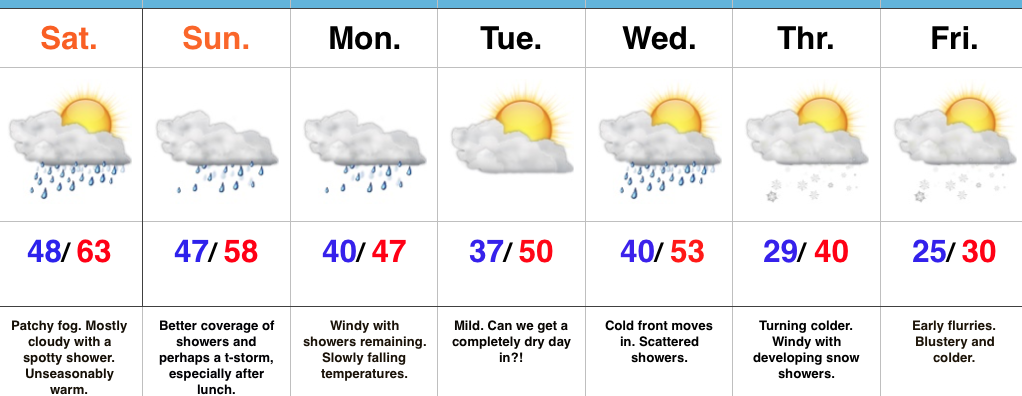
**We do note the NEW European Weeklies lock a period of cold into the east from mid-February through early March, including a stormy (snowy) look.  Will Old Man Winter have the final say?

Updated 7-day later this evening!

Permanent link to this article: https://indywx.com/2017/01/24/winter-returns/

Foggy Start; Winter Returns…

Screen Shot 2017-01-23 at 7.15.25 AMHighlights:

  • Dense fog this morning
  • Turning much colder this week
  • Scattered snow showers late week

Low Beams On…Dense fog engulfs most of central IN this morning.  Make sure you have the low beams on this morning as you head off to work and school and allow extra time.  A shower is possible at any point today, but particularly across the eastern half of the state.

Our next storm system will push through mid week.  Southwest winds will increase Wednesday and scattered showers will accompany a cold front moving through the state.  Temperatures will fall Wednesday night into Thursday and scattered snow showers will develop.

The theme late in the week and for the weekend will be a wintry one.  Upper level energy will interact with the colder conditions and result in scattered snow showers from time to time into the weekend.  The active northwest flow will remain into next week, as well, and we’ll have to keep a close eye for the prospects of a more “robust” clipper impacting the region just beyond this forecast period.

Upcoming 7-Day Precipitation Forecast:

  • Snowfall: Dusting – 1″
  • Rainfall: 0.10″ – 0.25″

Permanent link to this article: https://indywx.com/2017/01/23/foggy-start-winter-returns/

Spring-Like Weekend, But Changes Loom…

Screen Shot 2017-01-20 at 10.25.29 PMHighlights:

  • Spring-like weekend
  • Unsettled times continue
  • Winter returns

Rare January White Leg Alert…The big news this weekend will be temperatures close to 30 degrees above normal and a legitimate spring feel.  Average highs across central IN this time of year are in the middle 30s and temperatures this afternoon will zoom to the lower-middle 60s.  Patchy morning fog and drizzle will be with us, but we’re remaining optimistic we could squeeze a couple of looks at the sun during the day.  Count yourself lucky if you do, indeed, see that weird giant bright thing in the sky! 😉

A developing storm system will track east across the central Plains and into the TN Valley this weekend.  This will result in a significant severe weather outbreak across the south and increasing rain chances here for the back half of the weekend.  The magnitude of the rain and potential embedded storms remains in question, but shower chances will at least be on the increase Sunday afternoon into the evening.  We note short-term, higher resolution modeling hitting the locally heavy rain threat harder than global data early this morning (centered on Sunday evening) and we’ll keep a close eye on things as most central IN communities remain waterlogged.  Winds will increase Monday- NE shifting to the N and gusts to 40 MPH with leftover showers continuing.

Tuesday will present a bit of a break in our active pattern before a fast-moving cold front blows into town Wednesday with scattered showers amidst blustery conditions.

We turn colder (you knew this incredibly mild pattern had to break at some point) late week and upper level energy will help ignite snow showers with the return of the wintry feel Thursday into Friday.

Upcoming 7-Day Precipitation Forecast:

  • Snowfall: Dusting – 1″
  • Rainfall: 0.50″ – 0.75″

Permanent link to this article: https://indywx.com/2017/01/21/spring-like-weekend-but-changes-loom/

Weekend Video Update…

You must be logged in to view this content. Click Here to become a member of IndyWX.com for full access.  Already a member of IndyWx.com All-Access?  Log-in here.

Permanent link to this article: https://indywx.com/2017/01/20/weekend-video-update/

IndyWx.com