This content is password-protected. To view it, please enter the password below. Password:
You must be logged in to view this content. Click Here to become a member of IndyWX.com for full access. Already a member of IndyWx.com All-Access? Log-in here.
Interested in more in-depth long range forecast discussions, video updates, ag. forecasts, and seasonal outlooks? E-mail bill@indywx.com for more information.
As we begin to transition from winter to spring this weekend, it’s not only the impressive early season warmth that has our attention next week, but also a developing wet pattern.
A combination of ingredients will result in a rather prolonged moist southwesterly air flow, with a Gulf of Mexico connection. The end result is a wet pattern developing, especially come mid week.
So while you get ready to enjoy the warmer than normal spring feel, it may also be wise to have the rain gear handy.
Interested in more in-depth long range forecast discussions, video updates, ag. forecasts, and seasonal outlooks? E-mail bill@indywx.com for more information.
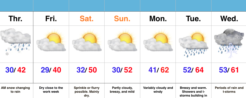
Snow Transitions To Rain…Snow spread over central IN during the overnight and most neighborhoods accumulated between 1″-2″. Warm air advection will result in snow transitioning to rain from south to north as we progress through the late morning hours. All in all, it’ll be a raw Thursday.
Weak high pressure will build in and result in dry conditions Friday with sunshine returning.
A fast moving system will clip the region Saturday with a sprinkle or flurry possible, but this doesn’t appear to be a big deal in the least.
The bigger story? The developing unseasonably warm period developing next week, but we caution this will also be a wet period as a prolonged SW flow transports moisture-rich Gulf of Mexico air into the region. Heavy rain totals will be a good bet.
This content is password-protected. To view it, please enter the password below. Password:
You must be logged in to view this content. Click Here to become a member of IndyWX.com for full access. Already a member of IndyWx.com All-Access? Log-in here.