April 2016 archive
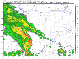
Heaviest concentration of storms Tuesday was along the I-70 corridor and points south. We think today coverage of rain and thunderstorms will be more widespread across the state…
We’re off to a cool and quiet start this morning, but think things will turn rather busy yet again as early as the early-mid afternoon hours. Unsettled conditions will continue through the night.
Latest scans of the HRRR future-cast radar product suggests we need to monitor for high wind potential during the early to mid afternoon hours. We’ll keep a close eye on this.
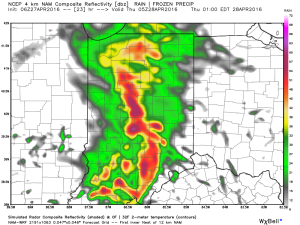
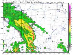 The high resolution NAM future-cast radar is slower, but also shows strong to possibly severe storms into central IN late tonight.
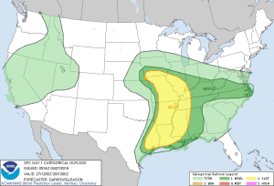
 The current SPC outlook highlights far southwestern IN for the chance of severe weather today. Don’t be surprised if this is expanded northeast with later updates today.
 Rainfall potential today-tonight should feature many neighborhoods accumulating an additional inch, with some locally heavier totals.
Permanent link to this article: https://indywx.com/another-round-of-storms-this-afternoon/
This content is password-protected. To view it, please enter the password below. Password:
You must be logged in to view this content. Click Here to become a member of IndyWX.com for full access. Already a member of IndyWx.com All-Access? Log-in here.
Permanent link to this article: https://indywx.com/long-range-client-video-discussion-3/
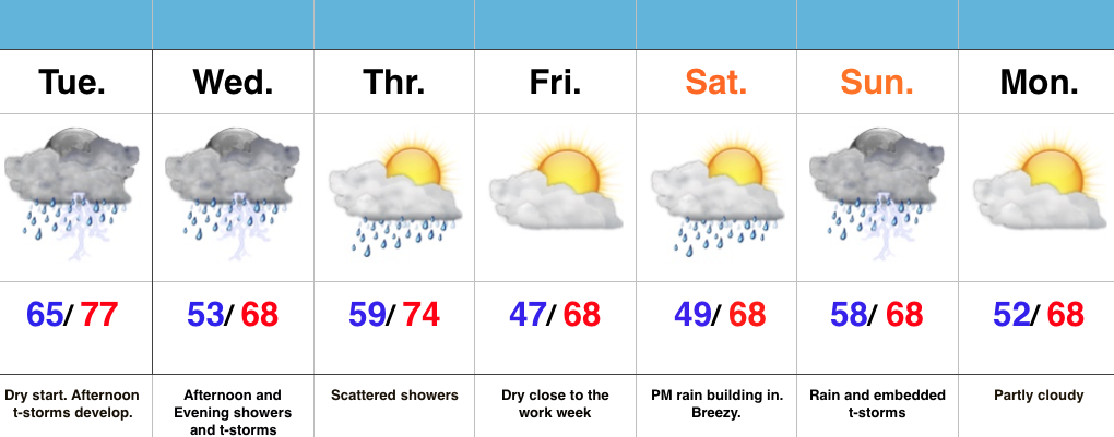 Highlights:
- T-storms develop this afternoon
- Another round of showers and t-storms push in Wednesday afternoon/ evening
- Briefly drier Friday
- New storm delivers a wet weekend
Turning Noisy This Afternoon…It’s a relatively quiet start to the day across central IN, but a cold front will help ignite rather robust shower and thunderstorm development as early as the lunchtime hour. Storms will grow in intensity and coverage as we progress through the afternoon and evening, especially along I-70 and points south. Locally heavy rain will be likely. Stronger storms will be capable of producing hail and damaging winds.
Another round of showers and thunderstorms are on deck Wednesday afternoon and evening. When all is said and done by Thursday morning, widespread rain totals of 1″ to 1.5″ will be a good bet, with locally heavier amounts.
Friday will feature a beautiful close to the work week with drier air working in and some sunshine. That said, the sunny skies won’t last as showers and thunderstorms return over the weekend.
Permanent link to this article: https://indywx.com/thunderstorms-fire-this-afternoon/
This content is password-protected. To view it, please enter the password below. Password:
You must be logged in to view this content. Click Here to become a member of IndyWX.com for full access. Already a member of IndyWx.com All-Access? Log-in here.
Permanent link to this article: https://indywx.com/client-long-range-video-update/
 Highlights:
- Lots of sun through the daytime
- Storms rumble in late tonight
- Unsettled mid week pattern
- New storm delivers rain and wind this weekend
Beautiful Today; Storms Arrive Late Tonight…We couldn’t ask for better weather through the daytime today (despite a gusty SW wind), but chances for rather noisy thunderstorms increase late tonight into the predawn hours Tuesday. Unsettled conditions remain Tuesday, including scattered thunderstorms especially across the I-70 corridor and points south. Locally hefty downpours will be possible.
More widespread showers and embedded thunder are on tap Wednesday into Thursday, especially through the morning hours Thursday. Widespread 1″-1.5″ rain totals are a good bet between now and Thursday morning, with some locally heavier amounts.
We still think we get a briefly drier air mass in here to close the work week, but this won’t last long. Our next storm system is dialed up for a weekend arrival and will provide a stiff easterly breeze and rain Saturday PM through Sunday.
Permanent link to this article: https://indywx.com/bumpy-ride-this-week/


 The high resolution NAM future-cast radar is slower, but also shows strong to possibly severe storms into central IN late tonight.
 The current SPC outlook highlights far southwestern IN for the chance of severe weather today. Don’t be surprised if this is expanded northeast with later updates today.
 Rainfall potential today-tonight should feature many neighborhoods accumulating an additional inch, with some locally heavier totals.